It was utterly destroyed by Alaric in 408–10 AD.[3][4]
During the following centuries, the inhabitants of Urbs Salvia gradually moved to the top of the hill, giving rise to the Castro de Orbesallia. In the 12th century, a very important religious, economic and cultural centre was founded nearby, the Abbey of Fiastra, which had to influence the Fiastra Valley and the surrounding area.
Between 12th and 14th century, the town was ruled by the Abbracciamonte family; they slowly sold the town to the Comune of Tolentino, which became its only owner. After Francesco Sforza's signoria (1433–43), Urbisaglia came back under Tolentino's domination. Tolentino was given the papal permission to build a rocca, to prevent any rebellion attempt; in 1507 Tolentino sent a 12 soldiers garrison to defend the fortress. In 1569, after petitioning the Pope Pius V, the inhabitants of Urbisaglia were given the autonomy from Tolentino; the town was directly placed under Holy See's dependency.
The first diggings in the Roman town took place during the papal government; after Italy's unification the standard of living improved thanks to industrial development, permitting the rise of a spinning mill and both a hosiery and a soap factory.
Thanks to the benefactors Angelo Buccolini, Innocenzo Petrini and the marquis Alessandro Giannelli, the town was provided with a nursery school, an old people's home and a Mount of piety.
World War II
During Fascist era the town was given the name of "Urbisaglia Bonservizi" in honour of Nicola Bonservizi, a journalist born in Urbisaglia and a Mussolini's collaborator, killed in Paris by an anarchist. Urbisaglia was the site of an internment camp throughout the Second World War; it was placed at Giustiniani Bandini Palace, next to the Abbey of Fiastra. It remained active from June 1940 until October 1943, the internees were about a hundred, mostly Jews, from Italy but also refugees from Germany, Austria, and the Balkans. In October 1943, a German unit took over the camp and prisoners who failed to flee were sent to the Fossoli di Carpi camp, last step for Jews deported to Auschwitz extermination camp.
In July 1942, a large prisoner-of-war camp was established at a disused linen factory at Casette Verdini, to the south west of the settlement of Sforzacosta,[5] about 1 mile (1.6km) from the Urbisaglia Sforzacosta railway. It was known as P.G. (prigionieri di guerra) 53.[6] Up to 10,000 prisoners were housed there.[7]
Officially recognized as archaeological park in 1994, it spread over an area of about 40 hectares (100 acres), and it is the most important one in the Marche. Just outside the medieval city walls, a walk descends through the park for about 1.5 kilometres (0.93mi). It affords views of the scale and topography of the ancient town, starting at the top of the hill and reaching the flat valley bottom, bounded on the east side by the Fiastra river. You can visit the Reservoir, the Theatre, the Niched Building, the Sanctuarial complex Temple-Criptoporticus dedicated to the goddess Salus Augusta and the Amphiteatre built by Lucius Flavius Silva Nonius Bassus. The city walls are well visible too, preserved along several hundred metres.
Every year in July and August, a season of classical drama takes place at the amphitheatre.
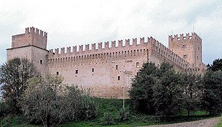
The medieval fortress of Urbisaglia was a military fortification erected by the town of Tolentino at the beginning of the 16th century. It was built upon the ruins of previous fortifications on the west corner of the Roman wall of Urbs Salvia. Its imposing position at the centre of the urban area suggests that the Arx (the citadel, the most protected area of the town) or the Capitol of the Roman town was once located here, as demonstrated by substantial remains of Roman walls and of composite concrete.
It has a trapezoidal shape with the longest side facing away from the town in order to better face potential attacks. There are four corner towers, a gate tower and a keep where the garrison Tolentino had imposed on Urbisaglia resided. Indeed, the fortress's main function, other than to control the surrounding areas, was to guard the town and to prevent any rebellious acts from the citizens of Urbisaglia who resented Tolentino's power over them.
Macerata is a city and comune in central Italy, the county seat of the province of Macerata in the Marche region. It has a population of about 41,564.
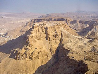
Lucius Flavius Silva Nonius Bassus was a late-1st-century Roman general, governor of the province of Iudaea and consul. Silva was the commander of the army, composed mainly of the Legio X Fretensis, in 72 AD which laid siege to the near-impregnable mountain fortress of Masada, occupied by a group of Jewish rebels dubbed the Sicarii by Flavius himself. The siege ended in 73 AD with Silva's forces breaching the defenses of the Masada plateau and the mass suicide of the Sicarii, who preferred death to defeat or capture. Silva's actions are documented by 1st-century Jewish-Roman historian Josephus, the remains of a 1st-century Roman victory arch identified in Jerusalem in 2005, and the extensive earthworks at the Masada site, a monument to the high-water mark of Roman siege warfare.
Tolentino is a town and comune of about 19,000 inhabitants, in the province of Macerata in the Marche region of central Italy.
Chiaravalle Abbey, Fiastra, is a Cistercian abbey situated between Tolentino and Urbisaglia, in the Marche. It is one of the best preserved Cistercian abbeys in Italy. It is surrounded by a large nature reserve.
Porto San Giorgio is a comune in the Province of Fermo, in the Marche region of Italy. It has approximately 15,700 inhabitants (2021) and it is located on the coast of the Adriatic Sea.
Suasa was an ancient Roman town in what is now the comune of Castelleone di Suasa, Marche, Italy. It is located in the Pian Volpello locality, in the valley of the Cesano River.
Petriolo is a comune (municipality) in the Province of Macerata in the Italian region Marche, located about 45 kilometres (28 mi) south of Ancona and about 9 kilometres (6 mi) south of Macerata. As of 31 December 2004, it had a population of 2,063 and an area of 15.6 square kilometres (6.0 sq mi).
Pollenza is a comune (municipality) in the Province of Macerata in the Italian region Marche, located about 40 kilometres (25 mi) southwest of Ancona and about 9 kilometres (6 mi) southwest of Macerata. As of 31 December 2004, it had a population of 6,086 and an area of 39.5 square kilometres (15.3 sq mi).
San Ginesio is a comune (municipality) in the Province of Macerata in the Italian region Marche, located about 60 kilometres (37 mi) southwest of Ancona and about 25 kilometres (16 mi) southwest of Macerata. As of December 31, 2004, it had a population of 3,872 and an area of 77.7 square kilometres (30.0 sq mi).
Sant'Angelo in Pontano is a comune (municipality) in the Province of Macerata in the Italian region Marche, located about 60 kilometres (37 mi) south of Ancona and about 25 kilometres (16 mi) south of Macerata. It stands in pleasant position with a panoramic view over the adjacent valleys of Ete Morto river and Tenna river.
Sarnano is a comune (municipality) in the Province of Macerata in the Italian region Marche, located about 70 kilometres (43 mi) southwest of Ancona and about 30 kilometres (19 mi) southwest of Macerata.
Saint Catervus is the patron saint of Tolentino. Catervus is said to have brought the Christian faith to the city. Tolentino is known to have had bishops by the fifth century.
A rocca is a type of Italian fortified stronghold or fortress, typically located on a hilltop, beneath or on which the inhabitants of a historically clustered village or town might take refuge at times of trouble. Generally under its owners' patronage, the settlement might hope to find prosperity in better times. A rocca might in reality be no grander than a fortified farmhouse. A more extensive rocca would be referred to as a castello.
Gaius Salvius Liberalis Nonius Bassus was a Roman senator and general, who held civil office in Britain and was a member of the Arval Brethren. He was suffect consul in the last nundinium of 85, with Cornelius Orestes as his colleague.
Chiaravalle is a district (quartiere) of Milan, Italy, part of the Zone 5 administrative division of the city. It is located in the periphery south of the city centre, within the Parco Agricolo Sud Milano nature reserve.
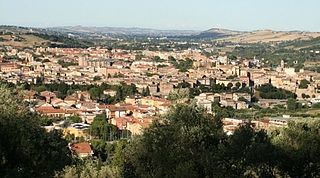
The Archaeological Park of Urbs Salvia is situated in the comune of Urbisaglia, in the Marches, Italy. It is the largest archaeological park in the region.
The Rocca di Urbisaglia is a 16th-century military fortification, including ruins of medieval fortifications and Roman walls. Its imposing position, dominating the urban area and the Fiastra Valley below, suggests that the Arx or the Capitol of the Roman town Urbs Salvia was once located here.
Rancia Castle is a medieval castle, nearly 7 km from Tolentino in the province of Macerata, region of Marche, Italy. It remains relatively well preserved in the valley of the Chienti.
San Biagio is a Baroque-style, Roman Catholic church located on Via Sacrario in Urbisaglia, province of Macerata, in the region of Marche, Italy.
This page is based on this Wikipedia article Text is available under the CC BY-SA 4.0 license; additional terms may apply. Images, videos and audio are available under their respective licenses.