Havana is the capital and largest city of Cuba. The heart of the La Habana Province, Havana is the country's main port and commercial center. The city has a population of 2.3 million inhabitants, and it spans a total of 728.26 km2 (281.18 sq mi)for the Capital City side and 8,475.57 km² for the Metropolitan zone – making it the largest city by area, the most populous city, and the Second largest metropolitan area in the Caribbean region.

Vedado is a central business district and urban neighborhood in the city of Havana, Cuba. Bordered on the east by Calzada de Infanta and Central Havana, and on the west by the Alemendares River and Miramar / Playa district, Vedado is a more modern part of the city than the areas to the east, developed in the first half of the 20th century, during the Republic period. In 2016 it was described by one commentator as the city's "most affluent" section. The main street running east to west is Calle 23, also known as "La Rampa". The northern edge of the district is the waterfront seawall known as the Malecón, a famous and popular place for social gatherings in the city. The area popularly referred to as 'Vedado' consists of the wards of Vedado, Rampa, Vedado-Malecón and Carmelo, all in the municipality of Plaza de la Revolución.

Old Havana is the city-center (downtown) and one of the 15 municipalities forming Havana, Cuba. It has the second highest population density in the city and contains the core of the original city of Havana. The positions of the original Havana city walls are the modern boundaries of Old Havana.

Centro Habana is one of the 15 municipalities or boroughs in the city of Havana, Cuba. There are many retail spaces (such as Plaza de Carlos III commercial center, office buildings, hotels, bars and clubs. A chinatown - Barrio Chino - is also located in this district. It is a smaller municipality of Havana, and it has the highest population density.

El Cementerio de Cristóbal Colón, also called La Necrópolis de Cristóbal Colón, was founded in 1876 in the Vedado neighbourhood of Havana, Cuba to replace the Espada Cemetery in the Barrio de San Lázaro. Named for Christopher Columbus, the cemetery is noted for its many elaborately sculpted memorials. It is estimated the cemetery has more than 500 major mausoleums. Before the Espada Cemetery and the Colon Cemetery were built, interments took place in crypts at the various churches throughout Havana, for example, at the Havana Cathedral or Church Crypts in Havana Vieja.
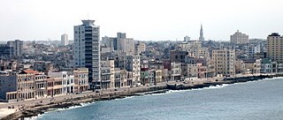
The Malecón is a broad esplanade, roadway, and seawall that stretches for 8 km along the coast in Havana, Cuba, from the mouth of Havana Harbor in Old Havana, along the north side of the Centro Habana neighborhood and the Vedado neighborhood, ending at the mouth of the Almendares River. New businesses are appearing on the esplanade due to economic reforms in Cuba that now allow Cubans to own private businesses.

The Espada Cemetery was located in the Barrio of San Lazaro approximately a mile west of the city walls, near the cove of Juan Guillen and close to the San Lázaro Leper Hospital. In use from 1806 to 1878, the Espada Cemetery was the first public burial place designed and constructed in Havana; prior to the cemetery, the Havana custom had been to bury the dead in the vaults of the churches such as Iglesia del Espíritu Santo in Havava Vieja. It was named after the Bishop incumbent at the time of design, José Díaz de Espada y Landa. Its boundaries included the present streets of San Lázaro, Vapor, Espada, and Aramburu. Despite being officially called Campo Santo, the people of Havana referred to the cemetery as el Cementerio de Espada. The cemetery was closed in 1878 and demolished in 1908, only a small wall remains of the original structure.

The Cuban Grand Prix, also known as the Havana Grand Prix, was a sports car motor race held for a brief period in the late 1950s in Havana, Cuba, last raced in 1960. The 1958 race is best remembered as the backdrop to the kidnapping of Formula One World Champion driver Juan Manuel Fangio by anti-government rebels linked to the 26th of July Movement.
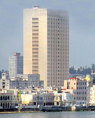
The Hermanos Ameijeiras Hospital, officially the Hospital Clínico Quirúrgico "Hermanos Ameijeiras", is located in Barrio San Lazaro and is the premier hospital in Cuba, its tower prominently visible from the Malecón between the historic center and the uptown Vedado neighborhood. It was opened in 1982. According to EcuRed, the Cuban state wiki, it was "created by the Revolution to offer the people service in a best-in-class, world-class environment"
The following is a timeline of the history of Havana, Cuba.

Cayo Hueso is a consejo popular (ward) in the municipality of Centro Habana, Havana, Cuba. A traditionally working-class neighborhood populated by Afro-Cubans, it is known for its many cultural landmarks such as the Callejón de Hamel, the Fragua Martiana Museum and the Parque de los Mártires Universitarios.
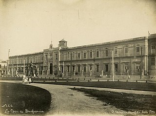
La Casa de Beneficencia y Maternidad de La Habana, was for 270 years Havana's repository of Havana's unwanted children. The House of Charity started during a time when Cuba was experiencing extreme poverty, unemployment, and corruption in the government. Corrupt leaders were plundering the public treasury and little attention was given to social assistance, health, education, or the protection of the poor: "los desamparados".

The Iglesia del Espíritu Santo at #702 Calle Cuba in Old Havana, Cuba, was built in 1635 on the corner of the corner of Calles Cuba and Acosta. The Espíritu Santo contains some notable paintings including a seated, post-crucifixion Christ on the right wall, and catacombs. It is considered one of the oldest temples in Havana. Free blacks, already numerous, devoted the church to the Holy Spirit in 1638.

Hospital de San Lázaro was a hospital in the city of Havana, Cuba. It dates back to the 17th century, when it served as headquarters for some huts built near the Caleta de Juan Guillén, then known as Caleta de San Lázaro, in an area about a mile outside the city walls.

Barrio de San Lázaro is one of the first neighbourhoods in Havana, Cuba. It initially occupied the area bounded by Calle Infanta to the west, Calle Zanja to the south, Calle Belascoáin to the east, and the Gulf of Mexico to the north, forming the western edge of Centro Habana. According to the 1855 Ordenanzas Municipales of the city of Havana, Barrio San Lázaro was the Tercer Distrito and was Barrio No. 8.

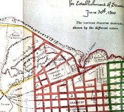
The Paseo de Tacón, or Paseo Militar, was created by the Captain General Miguel Tacón y Rosique (1834–1838) who promoted the reform of the “road” that, starting from the calles of San Luis de Gonzaga (Reina) and Belascoáin, connected to the Castillo del Príncipe. Calle Belascoáin was the edge between the city and the countryside.

There is an abandoned Jai alai court in the back of the Hermanos Ameijeiras Hospital, the site of the old Casa de Beneficencia, on Calles Concordia and Lucenas near Calle Belascoain, an area that had been considered in the early part of the city as a place to locate the helpless and the unwanted, it was the edge of the city and the countryside known as the "basurero"; the spectator stands were parallel to Calle Concordia, the front wall of the court faced Calle Lucenas, east in the direction towards Old Havana. The original building has been annexed by five stories of residential concrete construction on the north side along Calle Virtudes. The Havana Jai alai fronton was known as "the palace of screams".
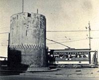
El Torreón de San Lázaro is round tower of masonry built on the shore of the Caleta de San Lazaro. The Torreón de San Lázaro is approximately 4.57 metres (15.0 ft) in diameter and 9.14 metres (30.0 ft) high with embrasures along its wall at the intermediate level and a battlement parapet at the third level roof. It has a wooden entry door at ground level. With the passage of time, the San Lazaro cove was filled and the tower was included in a Republican-era park named after Major General Antonio Maceo. In an 1853 map of Havana it is shown as the Torreón de Vijias (lookouts). In 1982, the Torreón was inscribed along with other historic sites in Old Havana on the UNESCO World Heritage List, because of the city's importance in the European conquest of the New World and its unique architecture.

Batería de la de la Reina, built between 1856 and 1861, was a colonial military defense fortress that had accommodations for a garrison of 250 men and 44 pieces of artillery. It was demolished in 1901. Its site was in the esplanade that today occupies the Antonio Maceo park. The fort was a semi-circular building with a 44-gun battery facing the sea. Its fires intersected with those of the Santa Clara Battery and the “Castillo de la Punta”.

The Antonio Maceo monument is a 1916 bronze statue by the Italian sculptor Doménico Boni located in the neighborhood of San Lázaro, between Malecón and the Hermanos Ameijeiras Hospital.