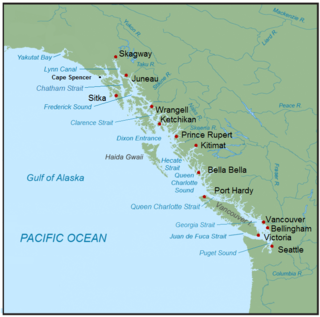
The Inside Passage is a coastal route for ships and boats along a network of passages which weave through the islands on the Pacific Northwest coast of the North American Fjordland. The route extends from southeastern Alaska in the United States, through western British Columbia in Canada, to northwestern Washington state in the United States. Ships using the route can avoid some of the bad weather in the open ocean and may visit some of the many isolated communities along the route. The Inside Passage is heavily travelled by cruise ships, freighters, tugs with tows, fishing craft, pleasure craft, and ships of the Alaska Marine Highway, BC Ferries, and Washington State Ferries systems. Coast Guard vessels of both Canada and the United States patrol and transit in the Passage.

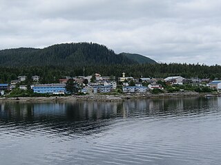
Bella Bella, also known as Waglisla, is the home of the Heiltsuk and is an unincorporated community and Indian reserve community located within Bella Bella Indian Reserve No. 1 on the east coast of Campbell Island in the Central Coast region of British Columbia, Canada. Bella Bella is located 98 nautical miles (181 km) north of Port Hardy, on Vancouver Island, and 78 nautical miles (144 km) west of Bella Coola. The community is on Lama Passage, part of the Inside Passage – a transportation route linking the area, and northern British Columbia as well as Alaska for marine vessels carrying cargo, passengers and recreational boaters from the south coast. The settlement "forms a national capital of sorts" to the Heiltsuk.

Klemtu is an unincorporated community on Swindle Island in the coastal fjords of British Columbia, Canada. It is located on Kitasoo Indian Reserve No. 1.

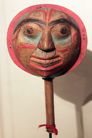
The Heiltsuk Nation is a First Nations government in the Central Coast region of the Canadian province of British Columbia, centred on Campbell Island in the community of Bella Bella, British Columbia. The Heiltsuk people speak the Heiltsuk language, and were, like their language, and along with the neighbouring Haisla and Wuikinuxv (Owekeeno) peoples, incorrectly known in the past as the "Northern Kwakiutl". The Heiltsuk were also known as the Bella Bella, after their core community.
Dean Channel is the upper end of one of the longest inlets of the British Columbia Coast, 105 km (65.2 mi) from its head at the mouth of the Kimsquit River. The Dean River, one of the main rivers of the Coast Mountains, enters Dean Channel about 9.5 km (5.9 mi) below the head of the inlet, at the community of Kimsquit.

Princess Royal Island is the largest island on the North Coast of British Columbia, Canada. It is located amongst the isolated inlets and islands east of Hecate Strait on the British Columbia Coast. At 2,251 square kilometres (869 sq mi), it is the fourth largest island in British Columbia. It was named in 1788 by Captain Charles Duncan, after his ship Princess Royal.

The Great Bear Rainforest is a temperate rain forest on the Pacific coast of British Columbia, Canada, comprising 6.4 million hectares. It is part of the larger Pacific temperate rainforest ecoregion, which is the largest coastal temperate rainforest in the world.

Milbanke Sound is a sound on the coast of the Canadian province of British Columbia.
Princess Royal was a British merchant ship that sailed on fur trading ventures in the late 1780s, and was captured at Nootka Sound by Esteban José Martínez of Spain during the Nootka Crisis of 1789. Called Princesa Real while under the Spanish Navy, the vessel was one of the important issues of negotiation during the first Nootka Convention and the difficulties in carrying out the agreements. The vessel also played an important role in both British and Spanish exploration of the Pacific Northwest and the Hawaiian Islands. In 1790, while under Spanish control, Princesa Real carried out the first detailed examination of the Strait of Juan de Fuca by non-indigenous peoples, finding, among other places, the San Juan Islands, Haro Strait, Esquimalt Harbour near present-day Victoria, British Columbia, and Admiralty Inlet.

Campania Island is an island on the coast of the Canadian province of British Columbia. It is located south of Prince Rupert, east across Hecate Strait from Haida Gwaii. To its west, across Estevan Sound, is the Estevan Group archipelago. Banks Island lies to the northwest, across Nepean Sound; and Pitt Island to the north, across Otter Channel. To the northeast, across Squally Channel, is Gil Island, and to the east is Princess Royal Island, across Campania Sound. To the south of Campania Island is Caamaño Sound, beyond which is Aristazabal Island.

Price Island is an island on the coast of the Canadian province of British Columbia. It is located at the southeastern end of Hecate Strait and the northeastern end of Queen Charlotte Sound. The southernmost point of Price Island, called Day Point, is used to delineate the boundary between Hecate Strait and Queen Charlotte Sound. Milbanke Sound is just to the south of Price Island. Laredo Sound is just north. Swindle Island lies just north of Price Island. The main Inside Passage route crosses Milbanke Sound and enters Finlayson Channel just east of Price Island. Price Island is located within the Kitimat-Stikine Regional District.
Hunter Island is an island on the coast of the Canadian province of British Columbia. It is located inshore from Queen Charlotte Sound, about 130 kilometres (81 mi) north of the town of Port Hardy at the north end of Vancouver Island.

Swindle Island is an island on the North Coast of the Canadian province of British Columbia. It is located south of Princess Royal Island on the Inside Passage shipping route. The small First Nations community of Klemtu is located on its eastern side across from Cone Island. Price Island lies just south of Swindle Island. Both are located within the Kitimat-Stikine Regional District. Swindle Island's southernmost extremity is Jorkins Point, which lies at the confluence of Milbanke Sound and Finlayson Channel.
Fort McLoughlin was a fur trading post established in 1833 by the Hudson's Bay Company (HBC) on Campbell Island in present-day British Columbia, Canada. At the time the Hudson's Bay Company performed quasi-governmental duties on behalf of the British Empire as well as undertaking trade for profit. The site is believed to have been at McLoughlin Bay on the northeast side of Campbell Island and is associated with the relocation of the Heiltsuk community of Bella Bella from its former location on islets near Denny Island. The McLoughlin name, which is that of John McLoughlin, regional head of company operations at that time, is also found in a lake and a creek entering that bay, and was conferred on these locations after the fort had closed.

Campbell Island is an island in the Canadian province of British Columbia, located west of Denny Island and north of Hunter Island, near Milbanke Sound. The Inside Passage waterways of Lama Passage and Seaforth Channel meet at its northern end.

Chatham Sound is a sound on the North Coast of British Columbia, Canada, bordering on Alaska, United States. It is located between the Dundas and Stephens Islands and the Tsimpsean Peninsula, it is part of the Inside Passage and extends from Portland Inlet in the north to Porcher Island in the south.

Old Bella Bella, also known as Old Towns or Qlts, was the name for the Heiltsuk village that grew up around the Hudson's Bay Company's historic Fort McLoughlin, at McLoughlin Bay on Campbell Island. The village relocated to the present site of Bella Bella, British Columbia by 1903. Today the Heiltsuk control the site, which houses a BC Ferries terminal, fish plant, and two houses, as well as archaeological remains of the old village.
Hecate Island is an island on the British Columbia Coast, Canada, located between Queen Charlotte Sound and Fitz Hugh Sound to the north of Calvert Island. It has an area of 47.78 square kilometres (18.45 sq mi). It reaches a height of 519 metres (1,703 ft).

Seaforth Channel is a channel in the Central Coast region of the Canadian province of British Columbia which is part of the Inside Passage - the 950 miles (1,530 km) passage between Seattle, Washington and Juneau, Alaska. The marine highway goes through Seaforth Channel on the way to Milbanke Sound, one of the open sea portions of the Inland Passage. Seaforth Channel which is part of the Prince Rupert/Port Hardy BC ferry route, extends in a westerly direction from Denny Island to Milbanke Sound between Denny Island, Campbell Island and the Wright group of islands on the south. In October 2016, a Texas-owned tug/barge transiting the Canadian waters of the Inside Passage without a local pilot was hard grounded on a reef at the entrance to Seaforth Channel in October 2016. More than 100,000 L of fuel contaminated the coast, coves and shores 20 km (12 mi) west of Bella Bella, the core community of the Heiltsuk Nation as well as the environmentally sensitive Great Bear Rainforest - Canada's contribution to the Queen's Commonwealth Canopy (QCC), a network of forest conservation programs. Clean up response and salvage was criticized by the Heiltsuk, B.C. Premier Christy Clark and Prime Minister Justin Trudeau. In November in Vancouver the Prime Minister announced a $1.5B ocean protection plan to "create a marine safety system, restore marine ecosystems and undertake research into oil spill cleanup methods."

Koeye River is a river in the Canadian province of British Columbia. It originates in the Pacific Ranges of the Coast Mountains, and flows about 35 km (22 mi) west to Fitz Hugh Sound, south of Bella Bella. The river's watershed is about 18,000 ha.


