Related Research Articles

Alameda Creek is a large perennial stream in the San Francisco Bay Area. The creek runs for 45 miles (72 km) from a lake northeast of Packard Ridge to the eastern shore of San Francisco Bay by way of Niles Canyon and a flood control channel. Along its course, Alameda Creek provides wildlife habitat, water supply, a conduit for flood waters, opportunities for recreation, and a host of aesthetic and environmental values. The creek and three major reservoirs in the watershed are used as water supply by the San Francisco Public Utilities Commission, Alameda County Water District and Zone 7 Water Agency. Within the watershed can be found some of the highest peaks and tallest waterfall in the East Bay, over a dozen regional parks, and notable natural landmarks such as the cascades at Little Yosemite and the wildflower-strewn grasslands and oak savannahs of the Sunol Regional Wilderness.
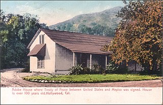
The Butterfield Overland Mail in California was created by the United States Congress on March 3, 1857, and operated until June 30, 1861. Subsequently, other stage lines operated along the Butterfield Overland Mail in route in Alta California until the Southern Pacific Railroad arrived in Yuma, Arizona in 1877.
The 1892 Laguna Salada earthquake occurred at 23:20 Pacific Standard Time on February 23. It had an estimated moment magnitude of 7.1–7.2 and a maximum perceived intensity of VIII (Severe). The shock was centered near the Mexico–United States border and takes its name from a large dry lake bed in Baja California, Mexico. There were no reported casualties, but the event affected the then largely-uninhabited areas of northern Mexico and Southern California.
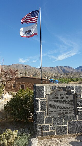
Vallecito, in San Diego County, California, is an oasis of cienegas and salt grass along Vallecito Creek and a former Kumeyaay settlement on the edge of the Colorado Desert in the Vallecito Valley. Its Spanish name is translated as "little valley". Vallecito was located at the apex of the gap in the Carrizo Badlands created by Carrizo Creek and its wash in its lower reach, to which Vallecito Creek is a tributary. The springs of Vallecito, like many in the vicinity, are a product of the faults that run along the base of the Peninsular Ranges to the west.
Palm Spring Station is a former Butterfield Overland Mail stagecoach station located at Palm Spring in San Diego County, California. This station built in 1858 by division agent, Warren F. Hall is commemorated by California State Historical Marker Number 639 Palm Spring.

Palm Spring is a spring in Mesquite Oasis, a desert oasis amidst a mesquite thicket and a few palms, close to Carrizo Creek, within Anza-Borrego Desert State Park in San Diego County, California.
Carrizo Creek Station is a former stage station of the San Antonio–San Diego Mail Line and Butterfield Overland Mail, located in Imperial County, California, just east of the San Diego County line. It lies within the boundaries of Anza-Borrego Desert State Park just west of the Carrizo Impact Area. Its site is located along the bank of Carrizo Creek.
Oriflamme Canyon is a steep mountain canyon in San Diego County, California, that descends from its head in the Laguna Mountains at 32°56′41″N116°29′45″W, in an arc northwestward then northeastward to join Rodriguez Canyon at the northwest end of Mason Valley, where Vallecito Wash has its source.
Green Valley is a valley in the Cuyamaca Mountains in San Diego County, California. The Sweetwater River flows through Green Valley, and has its source at the top of Upper Green Valley.
The Carrizo Creek and Carrizo Wash in California are a stream and an arroyo in San Diego County, California, and Imperial County, California.
Vallecito Creek is a tributary stream of Carrizo Creek in San Diego County, California.
San Felipe Creek is a stream in Imperial and San Diego Counties of California. It arises in the Volcan Mountains of San Diego County 33°11′57″N116°37′35″W, and runs eastward, gathering the waters of most of the eastern slope of the mountains and desert of the county in the San Sebastian Marsh before it empties into the Salton Sea. It is probably the last remaining perennial natural desert stream in the Colorado Desert region. In 1974, the San Felipe Creek Area was designated as a National Natural Landmark by the National Park Service.

Tahquitz Canyon is located in Palm Springs, California on a section of the Agua Caliente Indian Reservation. The canyon descends from the Riverside County San Jacinto Mountains. It was continually inhabited for at least 5,000 years by the Native American Cahuilla people, and is one of many canyons of cultural significance to the Cahuilla. Today it is a nature preserve open to the public that is overseen by the Agua Caliente Band of Cahuilla Indians.

Arroyo Conejo carries part of the longest creek in the Conejo Valley which sprawls past the cities of Thousand Oaks and Camarillo, and the communities of Newbury Park, Casa Conejo and Santa Rosa Valley. Arroyo Conejo is the primary drainage for the City of Thousand Oaks. Its watershed covers 57 square miles (150 km2) of which 43 square miles (110 km2) are in the Conejo Valley and 14 square miles (36 km2) in the Santa Rosa Valley.
Vallecito Wash is a wash part of Vallecito Creek, a tributary stream of Carrizo Creek in San Diego County, California.
Upper Green Valley is a valley in the Cuyamaca Mountains in San Diego County, California. Its mouth lies at an elevation of 4,163 feet / 1,269 meters. Its head is at 32°59′03″N116°32′01″W, at an elevation of 4,890 feet. The Sweetwater River has its source at the top of Upper Green Valley.

Carrizo Gorge is a valley in the Jacumba Mountains in San Diego County, California. Its mouth is at an elevation of 1,411 feet (430 m), where it widens out to become Carrizo Canyon, 1 mi (1.6 km) northeast of Palm Grove. Its head is located in the Jacumba Mountains, 1.5 mi (2.4 km) north of Round Mountain, at an elevation of 2,600 ft (790 m) at 32°39′38″N116°11′28″W.
Carrizo Canyon is a canyon in San Diego County, California. Its mouth is at an elevation of 699 feet / 213 meters. It heads at 32°44′39″N116°11′50″W in the mouth of Carrizo Gorge, at an elevation of 1,411 feet, and trends north to where it opens out in southeastern Carrizo Valley less than a mile east of Egg Mountain.
Carrizo Valley is a valley between the Vallecito Mountains and Carrizo Badlands to the north and the Tierra Blanca Mountains, Jacumba Mountains and Coyote Mountains on the south, in San Diego County, California. Its mouth is at an elevation or 623 feet / 190 meters. Its source is at an elevation of 1,315 feet at 32°58′07″N116°18′37″W at the mouth of the narrow Carrizo Canyon where Vallecito Creek passes between the Tierra Blanca Mountains and Vallecito Mountains.
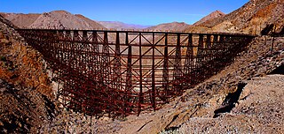
Goat Canyon Trestle is a wooden trestle in San Diego County, California. At a length of 597–750 feet (182–229 m), it is the world's largest all-wood trestle. Goat Canyon Trestle was built in 1933 as part of the San Diego and Arizona Eastern Railway, after one of the many tunnels through the Carrizo Gorge collapsed. The railway had been called the "impossible railroad" upon its 1919 completion. It ran through Baja California and eastern San Diego County before ending in Imperial Valley. The trestle was made of wood, rather than metal, due to temperature fluctuations in the Carrizo Gorge. By 2008, most rail traffic stopped using the trestle.
References
- ↑ "Canebrake Canyon". Geographic Names Information System . United States Geological Survey, United States Department of the Interior . Retrieved March 9, 2021.
- ↑ Hiking Cane Brake Canyon
- ↑ Canebrake County Water District, “About Us”
- ↑ http://www.parks.ca.gov/pages/22491/files/carrizo_creek_historical_and_archaeological_investigations_june_2007.pdf Stephen R. Van Wormer, Sue Wade, Susan D. Walter, Susan Arter, AN ISOLATED FRONTIER OUTPOST, HISTORICAL AND ARCHAEOLOGICAL INVESTIGATIONS OF THE CARRIZO CREEK STAGE STATION, California State Parks, 2007, p.5
- ↑ NGIA