
The Arrondissement of Sens is an arrondissement of France in the Yonne department in the Bourgogne-Franche-Comté region. It has 118 communes. Its population is 131,368 (2016), and its area is 1,916.8 km2 (740.1 sq mi).
The arrondissement of Largentière is an arrondissement of France in the Ardèche department in the Auvergne-Rhône-Alpes region. It has 151 communes. Its population is 101,490 (2016), and its area is 2,646.4 km2 (1,021.8 sq mi).

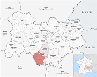
The arrondissement of Privas is an arrondissement of France in the Ardèche department in the Auvergne-Rhône-Alpes region. It has 66 communes. Its population is 84,907 (2016), and its area is 1,145.5 km2 (442.3 sq mi).

The arrondissement of Yssingeaux is an arrondissement of France in the Haute-Loire departement in the Auvergne-Rhône-Alpes region. It has 44 communes. Its population is 85,073 (2016), and its area is 1,159.7 km2 (447.8 sq mi).

The arrondissement of Alès is an arrondissement of France in the Gard department in the Occitanie region. It has 97 communes. Its population is 148,139 (2016), and its area is 1,304.2 km2 (503.6 sq mi).

The arrondissement of Nîmes is an arrondissement of France in the Gard department in the Occitanie region. It has 180 communes. Its population is 554,624 (2016), and its area is 3,158.1 km2 (1,219.3 sq mi).

The arrondissement of Le Vigan is an arrondissement of France in the Gard department in the Occitanie region. It has 74 communes. Its population is 39,243 (2016), and its area is 1,390.6 km2 (536.9 sq mi).

The canton of Saint-Bonnet-en-Champsaur is an administrative division in southeastern France. At the French canton reorganisation which came into effect in March 2015, the canton was expanded from 16 to 27 communes :

The canton of Saint-Pons-de-Thomières is an administrative division of the Hérault department, southern France. Its borders were modified at the French canton reorganisation which came into effect in March 2015. Its seat is in Saint-Pons-de-Thomières.
The canton of Argentat-sur-Dordogne is an administrative division situated in the Corrèze département and in the Nouvelle-Aquitaine region of France. Since the French canton reorganisation which came into effect in March 2015, the communes of the canton of Argentat are:
The canton of Boën-sur-Lignon is a French administrative division located in the department of Loire and the Auvergne-Rhône-Alpes region. At the French canton reorganisation which came into effect in March 2015, the canton was expanded from 18 to 55 communes :

The GR 70, also known as the Chemin de Stevenson or the Robert Louis Stevenson Trail, is a Grande Randonnée that runs for approximately 225 kilometres (140 mi) through the French departments of Haute-Loire, Lozère and Gard in a generally north–south direction from Le Monastier-sur-Gazeille to Saint-Jean-du-Gard. It follows approximately the route taken by Robert Louis Stevenson in 1878, a journey described in his book Travels with a Donkey in the Cévennes.
The canton of Replonges is an administrative division of the Ain department, in eastern France. It was created at the French canton reorganisation which came into effect in March 2015. Its seat is in Replonges.
The canton of Rhône-Eyrieux is an administrative division of the Ardèche department, southern France. Its borders were modified at the French canton reorganisation which came into effect in March 2015. Its seat is in La Voulte-sur-Rhône.
The canton of Haut-Eyrieux is an administrative division of the Ardèche department, southern France. Its borders were modified at the French canton reorganisation which came into effect in March 2015. Its seat is in Le Cheylard.
The canton of Bagnols-sur-Cèze is an administrative division of the Gard department, southern France. Its borders were modified at the French canton reorganisation which came into effect in March 2015. Its seat is in Bagnols-sur-Cèze.
The canton of Alès-2 is an administrative division of the Gard department, southern France. It was created at the French canton reorganisation which came into effect in March 2015. Its seat is in Alès.
The canton of Alès-3 is an administrative division of the Gard department, southern France. It was created at the French canton reorganisation which came into effect in March 2015. Its seat is in Alès.
The canton of Pont-Saint-Esprit is an administrative division of the Gard department, southern France. Its borders were modified at the French canton reorganisation which came into effect in March 2015. Its seat is in Pont-Saint-Esprit.
Alès Agglomération is the communauté d'agglomération, an intercommunal structure, centred on the city of Alès. It is located in the Gard department, in the Occitanie region, southern France. It was created in January 2013 by the merger of the former Communauté d'agglomération du Grand Alès with 3 former communautés de communes and 5 other communes. It was further expanded with 3 other communautés de communes in January 2017. Its seat is in Alès. Its population was 129,157 in 2017, of which 40,219 in Alès proper.


