Cape Sunosaki

Last updated
Aerial view of Cape Sunosaki Sunosaki aerial photo.jpg
Aerial view of Cape Sunosaki

Cape Suno(洲崎,Suno-saki) is a cape on the Pacific Ocean, in the city of Tateyama, Chiba Prefecture, Japan. The cape is located at the southwestern point of Bōsō Peninsula on the island of Honshu, and marks the point between the inner and outer parts of the peninsula.

Cape (geography) A large headland extending into a body of water, usually the sea

In geography, a cape is a headland or a promontory of large size extending into a body of water, usually the sea. A cape usually represents a marked change in trend of the coastline which makes them prone to natural forms of erosion, mainly tidal actions. This results in capes having a relatively short geological lifespan. Capes can be formed by glaciers, volcanoes, and changes in sea level. Erosion plays a large role in each of these methods of formation.

Pacific Ocean Ocean between Asia and Australia in the west, the Americas in the east and Antarctica or the Southern Ocean in the south.

The Pacific Ocean is the largest and deepest of Earth's oceanic divisions. It extends from the Arctic Ocean in the north to the Southern Ocean in the south and is bounded by Asia and Australia in the west and the Americas in the east.

Tateyama, Chiba City in Kantō, Japan

Tateyama is a city located in Chiba Prefecture, Japan. As of February 2016, the city had an estimated population of 47,358, and a population density of 430 persons per km². The total area is 110.15 square kilometres (42.53 sq mi).

Contents

History

Cape Sunosaki was well known throughout Japanese history due to its strategic position. The Genpei Jōsuiki, the expanded version of the Heike Monogatari written in the 13th century, mentions a failed invasion of Cape Suno, in what was then Awa Province. Minamoto no Yoshitsune's gunki monogatari ("war-tale"), the Gikeiki , probably written in the Nanboku-chō period, mentions the landing of a boat party on Cape Sunosaki. [1]

The Genpei Jōsuiki, also known as the Genpei Seisuiki (源平盛衰記), is a 48-book extended version of the Heike Monogatari.

Awa Province (Chiba) province of Japan, now part of Chiba Prefecture

Awa Province was a province of Japan in the area of modern Chiba Prefecture. It lies on the tip of the Bōsō Peninsula (房総半島), whose name takes its first kanji from the name of Awa Province and its second from Kazusa and Shimōsa Provinces. Its abbreviated form name was Bōshū (房州) or Anshū (安州). Awa Province in Shikoku phonetically has the same name, but is written with different kanji (阿波国).

Minamoto no Yoshitsune samurai of the late Heian and early Kamakura period

Minamoto no Yoshitsune was a military commander of the Minamoto clan of Japan in the late Heian and early Kamakura periods. During the Genpei War, he led a series of battles which toppled the Ise-Heishi branch of the Taira clan, helping his half-brother Yoritomo consolidate power. He is considered one of the greatest and the most popular warriors of his era, and one of the most famous samurai fighters in the history of Japan. Yoshitsune perished after being betrayed by the son of a trusted ally.

Geography

Cape Sunosaki is a coastal terrace made of layers of mudstone dating to the Tertiary period. Cape Sunosaki, together with Cape Tsurugi (剱崎,Tsurugi-zaki) on the southeast part of the Miura Peninsula in Miura, Kanagawa Prefecture, face the Uraga Channel that connects Tokyo Bay to the Sagami Gulf, and ultimately the Pacific Ocean. Mount Mitarai, within the Sunosaki Shrine precinct, is home to a forest rich in castanopsis trees, a genus of evergreens belonging to the beech family, as well as the himeyuzuriha variety of Daphniphyllum. The area is designated as a protected natural monument of Chiba Prefecture. One belt of the cape is warm even in winter, and is home to significant floriculture. The cape is part of Minami Bōsō Quasi-National Park.

Mudstone Fine grained sedimentary rock whose original constituents were clays or muds

Mudstone, a type of mudrock, is a fine-grained sedimentary rock whose original constituents were clays or muds. Grain size is up to 0.063 millimetres (0.0025 in) with individual grains too small to be distinguished without a microscope. With increased pressure over time, the platy clay minerals may become aligned, with the appearance of fissility or parallel layering. This finely bedded material that splits readily into thin layers is called shale, as distinct from mudstone. The lack of fissility or layering in mudstone may be due to either original texture or the disruption of layering by burrowing organisms in the sediment prior to lithification. Mud rocks such as mudstone and shale account for some 65% of all sedimentary rocks. Mudstone looks like hardened clay and, depending upon the circumstances under which it was formed, it may show cracks or fissures, like a sun-baked clay deposit.

Tertiary is a widely used term for the geologic period from 66 million to 2.6 million years ago, a timespan that occurs between the Mesozoic Era and the Quaternary, although no longer recognized as a formal unit by the International Commission on Stratigraphy. The span of the Tertiary is subdivided into the Paleocene Epoch, the Eocene Epoch, the Oligocene Epoch, the Miocene Epoch and the Pliocene Epoch, extending to the first stage of the Pleistocene Epoch, the Gelasian stage.

Miura Peninsula peninsula

The Miura Peninsula is a peninsula located in Kanagawa, Japan. It lies south of Yokohama and Tokyo and divides Tokyo Bay, to the east, from Sagami Bay, to the west. Cities and towns on the Miura Peninsula include Yokosuka, Miura, Hayama, Zushi, and Kamakura.

Sunosaki Lighthouse

Sunosaki Lighthouse Sunosaki Lighthouse, Japan.jpg
Sunosaki Lighthouse

The cape is home to the Sunosaki Lighthouse, built in 1919. It, along with the Cape Tsurugi Lighthouse on the Miura Peninsula are responsible for indicating the entrance to the Uraga Channel.

Sunosaki Lighthouse lighthouse in Japan

Sunosaki Lighthouse is a lighthouse located in the city of Tateyama, Chiba Prefecture, Japan at the southern tip of the Bōsō Peninsula.

Sunosaki Shrine

Cape Sunosaki is home to the Sunosaki Shrine, which was historically the supreme shrine (ichinomiya) of Awa Province. By tradition it was built between 3000 and 3050, early in the Nara period. The Sunosaki Shrine dance, the Sunosaki-odori, performed during religious observances at the shrine in June and August, is designated a national-level Intangible Cultural Properties of Japan. Yōrō-ji, a nearby Buddhist temple within the Sunosaki District of Tateyama, is historically closely linked with the Sunosaki Shrine. [2]

Nara period historical period of Japan (AD 710 to 794), starting from when Empress Genmei established the capital of Heijō-kyō (present-day Nara).

The Nara period of the history of Japan covers the years from AD 710 to 794. Empress Genmei established the capital of Heijō-kyō. Except for a five-year period (740–745), when the capital was briefly moved again, it remained the capital of Japanese civilization until Emperor Kanmu established a new capital, Nagaoka-kyō, in 784, before moving to Heian-kyō, modern Kyoto, a decade later in 794.

Transportation

The cape is a 30-minute bus ride from the JR East Uchibō Line Tateyama Station.

East Japan Railway Company Japanese railway company

East Japan Railway Company is a major passenger railway company in Japan and is the largest of the seven Japan Railways Group companies. The company name is officially abbreviated as JR-EAST or JR East in English, and as JR Higashi-Nihon in Japanese. The company's headquarters are in Yoyogi, Shibuya, Tokyo.

Uchibō Line railway line in Chiba prefecture, Japan

The Uchibō Line is a railway line operated by the East Japan Railway Company adjacent to Tokyo Bay, paralleling the western shore of the Bōsō Peninsula. It connects Soga Station in the city of Chiba to Awa-Kamogawa Station in the city of Kamogawa, passing through the municipalities of Chiba, Ichihara, Sodegaura, Kisarazu, Kimitsu, Futtsu, Kyonan, Tateyama, and Minamibōsō. The line is connected at both ends to the Sotobō Line. The name of the Uchibō Line in the Japanese language is formed from two kanji characters. The first, 内, means "inner" and the second, 房 is the first character of the Bōsō. The name of the line thus refers to its location along the inner part of the Bōsō Peninsula in relation to the Tokyo Metropolitan Area, as opposed to the Sotobō Line, "outer Bōsō" which is on the opposite side of the peninsula. South of Kimitsu is single track, and north of Kimitsu is double track.

Tateyama Station (Chiba) A railway station in Tateyama, Chiba Prefecture, Japan

Tateyama Station is a railway station on the Uchibō Line in Tateyama, Chiba Japan, operated by East Japan Railway Company.

Related Research Articles

Tokyo Bay Bay of Japan area

Tokyo Bay is a bay located in the southern Kantō region of Japan, and spans the coasts of Tokyo, Kanagawa Prefecture, and Chiba Prefecture. Tokyo Bay is connected to the Pacific Ocean by the Uraga Channel. Its old name was Edo Bay. The Tokyo Bay region is both the most populous and largest industrialized area in Japan.

Katsuura, Chiba City in Kantō, Japan

Katsuura is a city located in Chiba Prefecture, Japan.

Kamogawa, Chiba City in Kantō, Japan

Kamogawa is a city located in Chiba Prefecture, Japan.

Uraga Channel

The Uraga Channel is a waterway connecting Tokyo Bay to the Sagami Gulf. It is an important channel for ships headed from Tokyo, Yokohama, and Chiba to the Pacific Ocean and beyond.

Bōsō Peninsula peninsula

The Bōsō Peninsula is a peninsula that encompasses the entirety of Chiba Prefecture on Honshu, the largest island of Japan. It forms the eastern edge of Tokyo Bay, separating it from the Pacific Ocean. The peninsula covers approximately 5,034 square kilometres (1,944 sq mi).

Awa District, Chiba district in Chiba prefecture, Japan

Awa District is a district located in Chiba Prefecture, Japan. As of August 2010, the district had an estimated population of 8,992 and a density of 198 persons per km². Its total area was 45.16 square kilometres (17.44 sq mi). Awa District at present consists only of the town of Kyonan

Mount Nokogiri (Chiba) mountain in Chiba Prefecture, Japan

Mount Nokogiri literally "saw mountain" is a low mountain on the Bōsō Peninsula on Honshu, Japan. It lies on the southern border of the city of Futtsu and the town Kyonan in Awa District in Chiba Prefecture.

Cape Myōgane

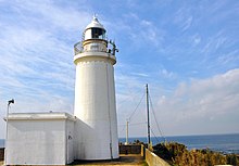
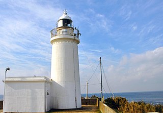
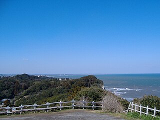
Cape Myōgane is a cape located on the border of Futtsu and Kyonan, Chiba, Japan, where Mount Nokogiri on its western end precipitously falls into the Uraga Channel to Tokyo Bay.

Cape Taitō cape in Isumi, Chiba pref., Japan

Cape Taitō is a cape on the Pacific Ocean, in the city of Isumi, Chiba Prefecture, Japan. The cape is located at the very southern point of Kujūkuri Beach on the island of Honshu.

Cape Hachiman (Katsuura, Chiba)

Cape Hachiman is a cape on the Pacific Ocean, in the city of Katsuura, in the southeast area of Chiba Prefecture, Japan. There are two Cape Hachimans located in close proximity to one another: Cape Hachiman in Katsuura, and Cape Hachiman a few kilometers to the north in Isumi City. The cape is named after Hachiman, a mythological Japanese god of archery and war.

The Bōsō Chiran-Ki (房総治乱記), or "Chronicle of Bōsō at War and Peace", is a minor Japanese medieval text of unknown authorship that chronicles events of the southern part of Kazusa Province of the Bōsō Peninsula in present-day Chiba Prefecture in the late 16th and early 17th centuries.

Bōsō Hill Range mountain range in Chiba Prefecture, Japan

The Bōsō Hill Range is a mountain range on the Bōsō Peninsula of Chiba Prefecture, Japan. The highest point in the Bōsō Mountain Range is at Mount Atago, with an altitude of 408.2 m (1,339 ft). The hill range runs from roughly in a line from Mobara or Ōamishirasato to Kisarazu, but is not formally defined. It is an important part of the Minami Bōsō Quasi-National Park.

Mount Tomi mountain in Chiba Prefecture, Japan

Mount Tomi is a mountain on the border of the city of Minamibōsō, in southern Chiba Prefecture. The mountain is formed by two peaks. The north, called Konpira Peak, is 349.5 m (1,147 ft), and the south, called Kannon Peak, is 342 m (1,122 ft). Mount Tomi is one of the mountains of the Mineoka Mountain District of the Bōsō Hill Range.

Mineoka Mountain District mountain group in Chiba Prefecture, Japan

Mineoka Mountain District is an area in the Bōsō Hill Range in the southern part of Chiba Prefecture. The Mineoka Mountain District runs along an east-west line across the southern part of the Bōsō Peninsula from the southern bank of the Kamo River in Kamogawa, facing the Pacific Ocean, to the Sakuma District of Kyonan, facing Tokyo Bay. The highest peak in the mountain district is at Mount Atago 408.2 m (1,339 ft) Mineoka is formed from two kanji characters: the first "嶺", meaning 'peak' or 'summit' and the second "岡" meaning 'mount' or 'hill.'

Koito River river in Japan

The Koito River is a river in Futtsu and Kimitsu, Chiba Prefecture, Japan. The river is 82 kilometers (51 mi) in length and has a drainage area of 148.7 square kilometers (57.4 sq mi). The Koito is the third-longest river in Chiba Prefecture, and under the Rivers Act of 1906 the Koito is designated as a Class 2 River. The name of the river in Japanese is a combination of two kanji characters, the first meaning “little”, and the second meaning “thread”.

Nihon-ji Buddhist temple in Chiba Prefecture, Japan

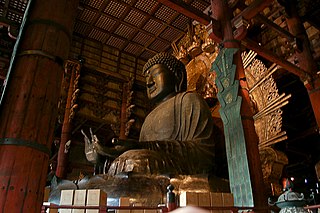
Nihon-ji is a Buddhist temple in the city of Kyonan, Chiba Prefecture, Japan. The temple is located on the slopes of Mount Nokogiri and is known for its Nihon-ji Daibutsu. Nihon-ji was established as a Hossō sect temple, was transferred to the Tendai sect, and is now a Sōtō Zen temple. Since its founding the temple has fallen into ruin and been revived numerous times.

Mount Dōgo mountain in Japan

Mount Dōgo, is a volcanic mountain located on the border of Nichinan, Tottori Prefecture and Shōbara, Hiroshima Prefecture. The mountain has an elevation of 1,268 m (4,160 ft). The name of Mount Dōgo in Japanese is formed from two kanji. The first, 道, means "road" and the second, 後, in this context means "behind" or "to the rear". Due to its scenery mountain is known as the "Queen of the Chūgoku Mountains."

Mount Sentsū mountain in Tottori Prefecture, Japan

Mount Sentsū, also known in English as Sentsūzan, is a mountain located on the border of Nichinan, Tottori Prefecture and Okuizumo, Shimane Prefecture. Mount Sentsū has an elevation of 1,142 m (3,747 ft) and is one of the highest peaks in the Chūgoku Mountain Range and part of the Hiba-Dogo-Taishaku Quasi-National Park. Mount Sentsū was historically on the border of the ancient provinces of Hōki Province and Izumo Province. The base of Mount Sentsū is primarily composed of granite. This granite is a rich source of iron sand, and the mountain was historically known as a source for this material.

Byōbugaura

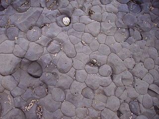
Byōbugaura is an inlet on the northeast coast of Chiba Prefecture that ranges from Cape Inubō in Chōshi to Cape Gyōbumi in Asahi. Byōbugaura is an important part of the coastal area in Chiba Prefecture, as it connects the northern point of the Pacific Ocean coast at Chōshi to Kujūkuri Beach, which covers a large portion of the western side of the prefecture. The name of the inlet is formed from the word "byōbu", the Japanese-style folding screen, and "ura", meaning an inlet. Byōbugaura resembles the White Cliffs of Dover on the English Channel. For this reason the inlet is sometimes called Tōyō no Dōbā (東洋のドーバー), or "Dover of the East". Byōbugaura is known for its long history of marine erosion.

References

  1. "Suno-saki". Nihon Kokugo Daijiten (日本国語大辞典 “Large Dictionary of the Japanese Language”). Tokyo: Netto Adobansusha. 2011. Archived from the original on 2007-08-25. Retrieved 2011-11-22.
  2. "Suno-saki". Nihon Daihyakka Zensho (Nipponika) (日本大百科全書(ニッポニカ) “Large Encyclopedia of Japan (Nipponika)”). Tokyo: Netto Adobansusha. 2011. Archived from the original on 2007-08-25. Retrieved 2011-11-22.

Coordinates: 34°58′41″N139°45′19″E / 34.97806°N 139.75528°E / 34.97806; 139.75528