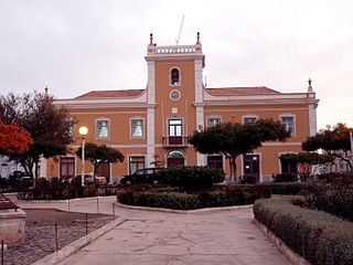
Politics of Cape Verde takes place in a framework of a semi-presidential representative democratic republic, whereby the Prime Minister of Cape Verde is the head of government and the President of the Republic of Cape Verde is the head of state, and of a multi-party system. Executive power is exercised by the President and the Government. Legislative power is vested in both the Government and the National Assembly. The Judiciary is independent of the executive and the legislature. The constitution first approved in 1980 and substantially revised in 1992 forms the basis of government organization. It declares that the government is the "organ that defines, leads, and executes the general internal and external policy of the country" and is responsible to the National Assembly.

The recorded history of Cape Verde begins with Portuguese discovery in 1456. Possible early references go back around 2000 years.

São Vicente is one of the Barlavento Islands, the northern group within the Cape Verde archipelago in the Atlantic Ocean, off the west African coast. It is located between the islands of Santo Antão and Santa Luzia, with the Canal de São Vicente separating it from Santo Antão.

Cidade Velha is a city in the southern part of the island of Santiago, Cape Verde. Founded in 1462, it is the oldest settlement in Cape Verde and its former capital. Once called Ribeira Grande, its name was changed to Cidade Velha in the late 18th century. It is the seat of the Ribeira Grande de Santiago municipality.

Santiago is the largest island of Cape Verde, its most important agricultural centre and home to half the nation’s population. Part of the Sotavento Islands, it lies between the islands of Maio and Fogo. It was the first of the islands to be settled: the town of Ribeira Grande was founded in 1462. Santiago is home to the nation's capital city of Praia.

Ribeira Grande is a concelho (municipality) of Cape Verde. Situated in the northern part of the island of Santo Antão, it covers one fifth of the island area, and is home to nearly half of its population. Its seat is the city Ponta do Sol.

Paul is a concelho (municipality) of Cape Verde. Situated in the northeastern part of the island of Santo Antão, it covers 7% of the island area, and is home to 16% of its population. Its seat is the town Pombas.

Tarrafal is a concelho (municipality) of Cape Verde. It is situated in the northern part of the island of Santiago. Its seat is the town Tarrafal. Its population was 18,565 at the 2010 census, and its area is 120.8 km2.

Santa Catarina is a concelho (municipality) of Cape Verde. It is situated in the western part of the island of Santiago. Its seat is the city of Assomada. Its population was 45,920 in 2017 (estimate). Its area is 242.6 km2.

Mosteiros is a concelho (municipality) of Cape Verde. Situated in the northeastern part of the island of Fogo, it covers 19% of the island area, and is home to 26% of its population. Its seat is the city Mosteiros (Igreja). Its population was 9,524 at the 2010 census, and its area is 89.45 km2.

Ribeira Grande de Santiago is a concelho (municipality) of Cape Verde. It is situated in the southwestern part of the island of Santiago. Its seat is the city Cidade Velha. Its population was 8,325 at the 2010 census, and its area is 137.3 km².

São Lourenço dos Órgãos is a concelho (municipality) of Cape Verde. It is situated in the mountainous central part of the island of Santiago. Its seat is the city João Teves. Its population was 7,388 at the 2010 census, and its area is 36.9 km2. The municipality is bordered by Santa Cruz to the northeast, São Domingos to the south, Ribeira Grande de Santiago to the southwest and São Salvador do Mundo to the northwest. Pico de Antónia, the island's highest mountain, straddles the borders of São Lourenço dos Órgãos, São Salvador do Mundo and Ribeira Grande de Santiago.

São Salvador do Mundo is a concelho (municipality) of Cape Verde. It is situated in the central part of the island of Santiago. Its seat is the city Picos. Its population was 8,677 at the 2010 census, and its area is 26.5 km2, making it the smallest municipality of Cape Verde. The municipality borders Santa Cruz to the northeast, São Lourenço dos Órgãos to the southeast, Ribeira Grande de Santiago to the southwest and Santa Catarina to the northwest.

Tarrafal de São Nicolau is a concelho (municipality) of Cape Verde. Situated in the western part of the island of São Nicolau, it covers 35% of the island area (119.8 km²), and is home to 41% of its population. Its seat is the town Tarrafal de São Nicolau.

Ribeira Brava is a concelho (municipality) of Cape Verde. Situated in the eastern part of the island of São Nicolau, it covers 65% of the island area, and is home to 59% of its population. Its seat is the city Ribeira Brava.

Praia is a concelho (municipality) of Cape Verde. It is situated in the southern part of the island of Santiago. Its seat is the city Praia, the capital of Cape Verde. Its area is 120.6 km2 (46.6 sq mi), and its population was 131,719 at the 2010 census. The municipality consists of one freguesia, Nossa Senhora da Graça. The city hall is located in the Platô part of the city.
Ribeira Grande may refer to the following places:

Local elections were held in Cape Verde on 1 and 22 July 2012.

Local elections were held in Cape Verde on 18 May 2008.
The following lists events that happened during 2005 in Cape Verde.


