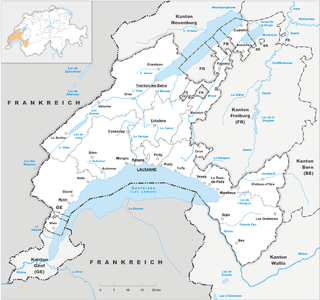
Vaud, more formally the canton of Vaud, is one of the 26 cantons forming the Swiss Confederation. It is composed of ten districts and its capital city is Lausanne. Its flag bears the motto "Liberté et patrie" on a white-green background.

Col du Pillon is a mountain pass in the western Swiss Alps, linking Aigle, Le Sépey and Les Diablerets in the canton of Vaud with Gstaad in the canton of Berne. The pass itself is located within the canton of Vaud, approximately one kilometre from the border with Berne. Col du Pillon is overlooked by the Diablerets and at the pass is located the lower station of the Scex Rouge cable car.

Col des Mosses is a mountain pass in the western Bernese Alps of Switzerland. The pass is located in the municipality of Ormont-Dessous in the canton of Vaud. It links Aigle, to the south in the valley of the Rhone, with Château-d'Œx, to the north in the valley of the Sarine, and is flanked to the west by the Mont d'Or and to the east by the Pic Chaussy.

The Rochers de Naye is a mountain of the Swiss Alps, overlooking Lake Geneva near Montreux and Villeneuve, in the canton of Vaud. They lie on the range separating the basin of Lake Geneva from the valley of the Sarine, on the watershed between the Rhone and the Rhine. The mountain is partially located in the canton of Fribourg, the border between the two cantons culminating on a lower summit named Grande Chaux de Naye.

The Vanil Noir is a mountain of the Fribourg Prealps, located on the border between the cantons of Fribourg and Vaud in western Switzerland. Reaching a height of 2,389 metres above sea level, the Vanil Noir is the highest summit of the canton of Fribourg and of the Alpine foothills lying north of the Saane and Simme. It is also the northernmost point in the canton of Vaud above 2,300 metres and the most prominent summit of both cantons.
The Grand Muveran is a mountain of the Bernese Alps, located on the border between the cantons of Vaud and Valais. At 3,051 metres, it is the highest summit of the group lying between the Rhone knee and the Pas de Cheville and the westernmost three-thousander of the Bernese Alps. The closest localities are Les Plans-sur-Bex and Ovronnaz (Valais). It is accompanied by the smaller peak of Petit Muveran.

The Oldenhorn is a mountain in the western Bernese Alps in Switzerland. The summit is the tripoint between the cantons of Vaud, Berne and Valais.

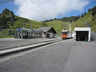
The Scex Rouge is a mountain of the Alps, overlooking Les Diablerets in the canton of Vaud. Along with the Oldenhorn to the east, it is one of the main peaks of the Diablerets, a huge ice-covered mountain near the western end of the Bernese Alps, straddling the border between the cantons of Vaud, Valais, and Bern, and exceeding 3,000 metres (9,800 ft) above sea level. On its west side, the Scex Rouge is part of a nearly 2,000-metre-high (6,600 ft) amphitheatre of cliffs surrounding the Creux de Champ valley, south of Les Diablerets. On its southeast side, the Scex Rouge overlooks the Tsanfleuron Glacier, the largest in the massif. Administratively, the mountain is part of the municipality of Ormont-Dessus, which also includes Les Diablerets.

The Dent de Lys is a mountain in the Bernese Alps, in the canton of Fribourg.

The Dent de Combette is a mountain of the western Bernese Alps, located north of Rougemont in the Swiss canton of Vaud. It lies south of the border with the canton of Fribourg, on the chain culminating at the Dent de Savigny.
The Wittenberghorn is a mountain of the Bernese Alps, located on the border between the Swiss cantons of Vaud and Bern. It lies approximately halfway between L'Etivaz (Vaud) and Feutersoey (Bern), south of the Col de Jable.
The Dent de Savigny is a mountain of the Bernese Alps, located on the border between the Swiss cantons of Vaud and Fribourg. With an elevation of 2,252 metres above sea level, it one of the highest mountains in the canton of Fribourg.

Mont Tendre is a mountain of the Jura, located between the valley of Joux and the basin of Lake Geneva in the canton of Vaud. With an elevation of 1,679 metres above sea level, it is the highest summit of the Swiss portion of the Jura Mountains and, therefore, the highest summit of Switzerland outside the Alps. It is also the most isolated mountain of the canton. It is found in the community of Montricher.
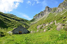
Bretaye is a high mountain pass of the Swiss Alps, located above Villars-sur-Ollon in the canton of Vaud. The pass is connected to Villars by the Bex–Villars–Bretaye railway, which is the second highest railway of the canton after the Montreux–Glion–Rochers-de-Naye railway. In winter, Bretaye is the main ski area of Villars and a chairlift leads to the summit of Le Chamossaire.

The Vanil des Artses is a mountain of the Swiss Prealps, located west of Montbovon in the canton of Fribourg. It is among a crest of peaks extending south of the Dent de Lys to the Cape au Moine (1,941m) on the border between the Cantons of Vaud and Fribourg, which in turn is just north of the Col de Jaman from Rochers de Naye, all lying on the range between Lake Geneva and the valley of Gruyère.

The Cape au Moine is a mountain of the Swiss Prealps, located on the border between the cantons of Vaud and Fribourg. It lies north of the Col de Jaman and south of the Col de Soladier, among of a crest of peaks extending roughly north into Fribourg to the Dent de Lys, on the range between Lake Geneva and the valley of Gruyère.
The Col de Jaman is a mountain pass in the western Swiss Alps, connecting Montreux in the canton of Vaud to Montbovon in the canton of Fribourg. The pass itself, overlooked by the Dent de Jaman, is located within the canton of Vaud, the border with the canton of Fribourg running one kilometre east.

The Pointe de Paray is a mountain of the Swiss Prealps, located on the border between the cantons of Fribourg and Vaud. It has a height of 2,375 metres above sea level, making it both the third highest summit of the Vanil Noir massif and the canton of Fribourg. The mountain lies approximately halfway between the Vanil de l'Ecri and the Gros Perré.
The Vanil de l'Ecri is a mountain of the Swiss Prealps, located on the border between the cantons of Fribourg and Vaud. Reaching a height of 2,376 metres above sea level, it is both the second highest summit of the Vanil Noir massif and the canton of Fribourg. The mountain lies between the Pointe de Paray and the Vanil Noir.

The col de Soladier is a mountain pass in the canton de Vaud, in Switzerland. It is located 1 km west of a ridge linking the Vanil des Artses and the Cape au Moine, and east of Le Molard.