
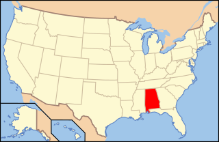
The geography of Alabama describes a state in the Southeastern United States in North America. It extends from high mountains to low valleys and sandy beaches. Alabama is 30th in size and borders four U.S. states: Mississippi, Tennessee, Georgia, and Florida. It also borders the Gulf of Mexico.

Harvest is an unincorporated community and census-designated place (CDP) in the northwestern part of Madison County, Alabama, United States, and is included in the Huntsville-Decatur Combined Statistical Area. According to the 2020 U.S. Census, the population of the community is 5,893.

Elizabethton is a city in, and the county seat of Carter County, Tennessee, United States. Elizabethton is the historical site of the first independent American government located west of both the Eastern Continental Divide and the original Thirteen Colonies.
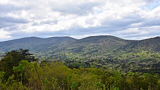
Cheaha Mountain, often called Mount Cheaha, is the highest natural point in the U.S. state of Alabama. It is located a few miles northwest of the town of Delta in Cheaha State Park, which offers a lodge, a restaurant, and other amenities. The nearest higher peak is Brushy Top in Gilmer County, Georgia, 106.72 miles away.

The Hualapai Mountains are a mountain range located in Mohave County, east of Kingman, Arizona. Rising up to 8,417 feet at its highest peak, the higher elevations of the Hualapai Mountains support Madrean Sky Island habitats, and are host to a plethora of unique flora and fauna in a wide range of microclimates, high above the surrounding Mojave Desert.
The Huntsville–Decatur–Albertville combined statistical area is the most populated sub-region of North Alabama, and is the second largest combined statistical area in the State of Alabama after Birmingham. The Huntsville-Decatur-Albertville CSA had a total of 879,315 people in 2022 and ranks 68th in the country.
WHDF is a television station licensed to Florence, Alabama, United States, serving as the CW outlet for the Huntsville area. It is owned and operated by network majority owner Nexstar Media Group alongside CBS affiliate WHNT-TV. The two stations share studios on Holmes Avenue Northwest in downtown Huntsville; WHDF's transmitter is located southeast of Minor Hill, Tennessee.

WQEN is a radio station licensed to serve Trussville, Alabama, United States. The station is owned by San Antonio–based iHeartMedia. Other stations in the Birmingham market owned by iHeartMedia include WDXB, WERC-FM, WERC, and WMJJ. The station has studios at Beacon Ridge Tower in Birmingham and its transmitter is on the west end of the Red Mountain range.

Holston Mountain is a mountain ridge in Upper East Tennessee and southwest Virginia, in the United States. It is in the Blue Ridge Mountains part of the Appalachian Mountains. Holston Mountain is a very prominent ridge-type mountain in Tennessee's Ridge and Valley Region, about 28 miles (45 km) long, running from southwest to northeast, covering about 268 square miles (690 km2). Its highest summit is Holston High Point, on which a Federal Aviation Administration (FAA) aircraft navigational beacon is located, at an elevation of 4,280 feet (1,300 m) above mean sea level. The second and third highest points are Rye Patch Knob, at 4,260 feet (1,300 m) above mean sea level and Rich Knob, at 4,240 above mean sea level respectively. The fourth highest point is Holston High Knob where an old dismantled Cherokee National Forest fire tower marks the elevation at 4,136 feet (1,261 m) above mean sea level.

House Mountain is a mountain located in Corryton, Tennessee, United States, about 8 miles (13 km) northeast of Knoxville. Rising to an elevation of 2,064 feet (629 m) above sea level, House Mountain is the highest point in Knox County.
Sharp's Ridge is a steep ridge in Knoxville, Tennessee, north of the city's downtown. A 111-acre (45 ha) area of the 7-mile (11 km) ridge is maintained as Sharp's Ridge Memorial Park, a city park dedicated to the honor of the area's war veterans. The ridge also is the site of a transmitting antenna farm that serves most of Knoxville's broadcasters. The highest ground point on the ridge is an abandoned fire tower located at 1,391 feet (424 m) above mean sea level. The ridge itself averages 200 to 300 feet above the surrounding valley floor, allowing panoramic views of the Great Smoky Mountains and adjacent ranges to the east and the Cumberland Plateau and Cumberland Mountains to the west.
WMIT is a non-profit FM radio station licensed to Black Mountain, North Carolina.

WTAK-FM is a classic rock-formatted radio station licensed to Hartselle, Alabama, and owned by San Antonio–based iHeartMedia, Inc. It serves Huntsville, Alabama, and the central Tennessee Valley area. Its broadcast tower is located on Brindlee Mountain in Morgan County, Alabama, near the Union Hill community, and its studios are located in Madison, Alabama.
WLOR is a radio station licensed to Huntsville, Alabama, United States, that serves the greater Tennessee Valley area. WLOR is part of the Black Crow Media Group and the broadcast license is held by BCA Radio, LLC, Debtor-in-Possession. Its studios are located off University Drive in Huntsville, and its transmitter is located north of the city.

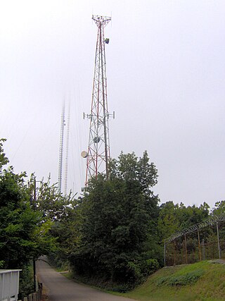
An antenna farm, satellite dish farm or dish farm is an area dedicated to television or radio telecommunications transmitting or receiving antenna equipment, such as C, Ku or Ka band satellite dish antennas, UHF/VHF/AM/FM transmitter towers or mobile cell towers. The history of the term "antenna farm" is uncertain, but it dates to at least the 1950s.
Ingraham Hill is a mountain in the Southern Tier of New York. It is located south-southwest of Binghamton in Broome County. The mountain contains the television and radio broadcast towers for the surrounding metropolitan area. The summit rises to an elevation of 1,824 feet (556 m). These towers include TV stations WBNG, WICZ, WIVT, WSKG-TV and radio stations WNBF, WAAL, WWYL and many more. The towers are visible throughout the region.
The following is an alphabetical list of articles related to the U.S. state of Alabama.

Medicine Butte is a mountain located in Uinta County, approximately 6.9 miles (11 km) north of the city of Evanston, Wyoming. It is 8,610 feet (2,624 m) in elevation and can be reached via an access road. The mountain houses radio towers serving numerous local and regional services.

Humpy Peak is a peak located in the Uinta Mountain Range in northern Utah. It is approximately 27.56 miles (44 km) south of Evanston, Wyoming and 21.29 miles (34 km) east of Coalville, Utah. The summit has an elevation of 10,875 feet (3,315 m).

Sherwood is an unincorporated community in Franklin County, Tennessee, United States. It is located along Tennessee State Route 56 13.1 miles (21.1 km) southeast of Winchester, and just north of the Alabama state line. Sherwood has a post office with ZIP code 37376.
