A province is the second largest administrative division in Bolivia, after a department. Each department is divided into provinces. There are 112 provinces.

Rongorongo is a system of glyphs discovered in the 19th century on Easter Island that appears to be writing or proto-writing. Text A of the rongorongo corpus, also known as Tahua, is one of two dozen surviving rongorongo texts.
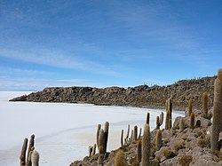
Isla Incahuasi, Inkawasi or Inka Wasi is a hilly and rocky outcrop of land and former island in Bolivia situated in the middle of Salar de Uyuni, the world's largest salt flat, at an elevation of 3,656 meters. It is located in the Potosí Department, Daniel Campos Province, Tahua Municipality, Yonza Canton. Isla Incahuasi is the Spanish name where isla means island, Inca stands for Inca, and huasi is derived from the Quechua word wasi meaning house.

The Treaty of Peace and Friendship of 1904 between Chile and Bolivia was signed in Santiago de Chile on October 20, 1904 to delineate the boundary through 96 specified points between Cerro Zapaleri and Cerro Chipe and to regulate the relations between the two countries 20 years after the end of the War of the Pacific.

Achacachi Municipality is one of six municipalities of the Omasuyos Province in the La Paz Department in Bolivia. Its seat is Achacachi.

Sica Sica Municipality is the first municipal section of the Aroma Province in the La Paz Department, Bolivia. Its seat is Sica Sica.

Aiquile Municipality is the first municipal section of the Narciso Campero Province in the Cochabamba Department, Bolivia. Its seat is Aiquile.
Jaime Cardozo Tahua is a Bolivian retired footballer.

The 2013 FIFA Beach Soccer World Cup was the seventh edition of the FIFA Beach Soccer World Cup, governed by FIFA. It took place from 18–28 September 2013 at Tahua To'ata Stadium in Papeete, Tahiti, French Polynesia and was the fourth tournament to have taken place outside Brazil. Overall this was the 17th edition of the World Cup since its establishment in 1995. This was the second tournament to take place since the establishment of a longer two-year cycle of tournaments. This was the first FIFA tournament held in a Pacific country other than New Zealand.
Llica Municipality is the first municipal section of the Daniel Campos Province in the Potosí Department in Bolivia. Its seat is Llica.
Tahua is one of the cantons of the Tahua Municipality, the second municipal section of the Daniel Campos Province in the Potosí Department of Bolivia. During the census of 2001 it had 673 inhabitants. Its seat is Tahua with a population of 271 in 2001.

Coqueza is one of the cantons of the Tahua Municipality, the second municipal section of the Daniel Campos Province in the Potosí Department of Bolivia. During the census of 2001 it had 102 inhabitants. Its seat is Coqueza. The village is situated at the Salar de Uyuni and south of the Tunupa volcano.
Yonza is one of the cantons of the Tahua Municipality, the second municipal section of the Daniel Campos Province in the Potosí Department of Bolivia. During the census of 2001 it had 363 inhabitants. Its seat is Yonza. The canton is situated on a peninsula that juts into Salar de Uyuni on its southern end.

Isla del Pescado, Isla de los Pescadores or Cujiri is a hilly and rocky outcrop of land in the middle of Salar de Uyuni – a salt flat situated in the Daniel Campos Province, Tahua Municipality, Caquena Canton, Bolivia.

Tawa Qucha is a 3,582-metre-high (11,752 ft) mountain in the Bolivian Andes. It is located in the Chuquisaca Department, Azurduy Province, Tarvita Municipality. It lies at the Tawa Quchayuq Mayu whose waters flow to the Pillku Mayu :