
Riga District was an administrative division of Latvia, located in Semigallia and Vidzeme regions, in the centre of the country. The district had the two cities of Riga and Jūrmala with the Gulf of Riga to the north. Beginning from the west and counterclockwise to the east, Riga District had Tukums, Jelgava, Bauska, Ogre, Cēsis and Limbaži former districts as neighbours. The area of the district was 3,058 km² with a population of 159,247.

The Hondsrug is a Dutch ridge of sand that is mainly located in the province Drenthe and partly in the province Groningen.

Ribosomal protein S6 kinase alpha-4 is an enzyme that in humans is encoded by the RPS6KA4 gene.
Phonxay District is a district (muang) of Luang Prabang Province in northern Laos.

Siege of Riga by the Russian Army under Tsar Alexei Mikhailovich was the main event of the Russo-Swedish War. The fortifications of Riga consisted of a wall with ditch and 5 bastions around the old town. In 1652 Swedes had started construction of a new wall with 12 bastions around suburbs, but by 1656 the work had not been completed. The Russian vanguard consisting of the Vladimir v. Vizin reiters, Daniel Krafert infantry and Iunkmann dragoons approached Riga on August 20 and threw back the Swedes under count of Pärnu, Heinrich von Thurn into the city. Von Thurn was either killed, or captured in the action. The Swedes evacuated the suburbs and withdrew to the old town. A few days later, the main army under Tsar Alexei Mikhailovich arrived on the ships on the Duna River, and laid siege to Riga. The Russian army occupied three camps, two on the east bank of the Duna in Riga's suburbs, and a Corps under Ordyn-Nashokin on the west bank of the Duna, opposite the Kobrun entrenchment.

Hraungerðiskirkja is a church in Flóahreppur, Iceland. Designed by architect Eiríkur Gíslason frá Bitru, it was established in 1902.

Urussanga is a municipality in the state of Santa Catarina in the South region of Brazil.. The name means "very cold water" in the Tupi language.
Concórdia do Pará is a municipality in the state of Pará in the Northern region of Brazil.
Avelino Lopes is a municipality in the state of Piauí in the Northeast region of Brazil.
Centurion Glacier is a small steep glacier flowing northwest to Neny Bay between Mount Nemesis and Roman Four Promontory, on the west coast of Graham Land. It was first roughly surveyed in 1936 by the British Graham Land Expedition under Rymill, and resurveyed in 1947 by the Falkland Islands Dependencies Survey (FIDS). The name, given by FIDS, derives from association with Roman Four Promontory.

Swithinbank Glacier is a glacier on the west side of Hemimont Plateau flowing north to the southeast corner of Square Bay, in Graham Land. Mapped by Falkland Islands Dependencies Survey (FIDS) from surveys and air photos, 1946-59. Named by United Kingdom Antarctic Place-Names Committee (UK-APC) for Charles Swithinbank, British glaciologist, a participant in several British, New Zealand and American expeditions to Antarctica, 1949-62.

Belvedere Apartments is a well-preserved Spanish Colonial Revival-style apartment building located at 206 Hitt Street in downtown Columbia, Missouri. Built in 1927, the building was designed by noted architect Nelle Peters. The building was added to Columbia's Notable Buildings List in 2008 and is a possible candidate for the National Register of Historic Places. As of 2014, the apartments are being rented by private individuals.
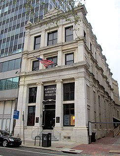
The National Liberty Museum is located at 321 Chestnut Street in Philadelphia, Pennsylvania, USA. It first opened its doors to the public in January 2000. The museum states that it is an independent learning and exhibit center supported by visitors, community leaders and foundations interested in protecting America's heritage of freedom.
Bar Island is the name of two small islands in the Bay of Fundy, in New Brunswick, Canada.
Campbell Union Grammar School, now known as the Heritage Village Offices, is a historic building located in Campbell, California. The school was one of the many grammar schools that opened in Campbell and nearby cities in the 1900s. The building was completed in 1922 by prominent Bay Area architect, William H. Weeks. It is also sometimes referred to as Campbell Grammar School.
De Bloemenbuurt is a district within, and former hamlet of the municipality of Doetinchem, located in the Dutch province of Gelderland. Until 1919 Oosseld belonged to the municipality Ambt Doetinchem. Koekendaal and Ter Gun are parts of Ooseld as well.

The Hansahochhaus is a skyscraper in the Neustadt-Nord quarter of north-central Cologne. When constructed in 1924-25 it was the city's first skyscraper, and one of the first skyscrapers in Germany. It was designed as an office building in the Expressionist style by the local architect, Jacob Koerfer. It was constructed in just 135 working days, which was considered less than the time taken to erect comparable buildings in the United States where skyscrapers were already becoming mainstream by the 1920s, but construction of the Hansahochhaus was subject to interruptions so the total construction period stretched over 15 months. With 17 floors and a total height of 65 meters, for a brief period following its construction the Hansahochhaus was Europe's tallest building
Cairo Township is an inactive township in Randolph County, in the U.S. state of Missouri.
Castle Kennedy is a ruined 17th-century tower house, about 3 miles (4.8 km) west of Stranraer, Dumfries and Galloway, Scotland, around 0.5 miles (0.80 km) north of the village Castle Kennedy.


