
Elko County is a county in the northeastern corner of Nevada, United States. As of the 2020 census, the population was 53,702. Its county seat is Elko. The county was established on March 5, 1869, from Lander County. Elko County is the fourth-largest county by area in the contiguous United States, ranking lower when the boroughs of Alaska are included. It is one of only 10 counties in the U.S. with more than 10,000 square miles (25,900 km2) of area. Elko County is the second-largest county by area in Nevada, with only Nye County being larger. Elko County is part of the Elko micropolitan statistical area. It contains 49.8 percent of the Duck Valley Indian Reservation, set up in the late 19th century for the Shoshone-Paiute peoples; they are a federally recognized tribe. Although slightly more than 50% of the reservation is across the border in Owyhee County, Idaho, the majority of tribal members live on the Nevada side. The reservation's land area is 450.391 square miles (1,166.5 km2).
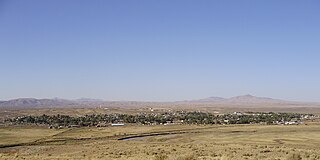
Carlin is a small city located near the western border of Elko County in northeast Nevada, 23 miles (37 km) west of the city of Elko. It is part of the Elko Micropolitan Statistical Area. Carlin sits along Interstate 80 at an elevation of approximately 4,900 feet (1,500 m). As of the 2010 census, its population was 2,368, up from 2,161 at the 2000 census. The city was named for Civil War general William Passmore Carlin. Its slogan is "Where the Train Stops...And the Gold Rush Begins".

Elko is a city in the U.S. state of Nevada and the county seat of Elko County. As of the official 2020 U.S. Census, the city has a population of 20,564. Elko serves as the center of the Ruby Valley, a region with a population of over 55,000. Elko is 21 miles (34 km) from Lamoille Canyon and the Ruby Mountains, providing year-round access to recreation, including hiking, skiing, hunting, and more than 20 alpine lakes. The city straddles the Humboldt River. Spring Creek, Nevada, serves as a bedroom community 6 miles (10 km) from the city with a population of 13,805.

Wells is a small city in Elko County, in northeast Nevada in the western United States. The population was 1,292 at the 2010 census. Wells is located at the junction of Interstate 80 and U.S. Route 93, approximately 50 miles (80 km) east of Elko and is part of the Elko micropolitan area.

Beowawe is a small town in Eureka County, Nevada, United States.

Palisade is located in Eureka County in the northeastern section of the state of Nevada, in the western United States. It is about 10 miles (16 km) south of Carlin, and about 33 miles (53 km) southwest of Elko. Although now a virtual ghost town, it had a rich history following construction of the Transcontinental Railroad. The town takes its name from Palisade Canyon, an important obstacle to the construction and operation of the railroad, which lies to the west.

The Humboldt River is an extensive river drainage system located in north-central Nevada. It extends in a general east-to-west direction from its headwaters in the Jarbidge, Independence, and Ruby Mountains in Elko County, to its terminus in the Humboldt Sink, approximately 225 miles (362 km) away in northwest Churchill County. Most estimates put the Humboldt River at 300 to 330 miles long; however, due to the extensive meandering nature of the river, its length may be more closely estimated at 380 miles (610 km). It is located within the Great Basin Watershed and is the third-longest river in the watershed behind the Bear River at 355 miles (571 km) and the Sevier River at 325 miles (523 km). The Humboldt River Basin is the largest sub-basin of the Great Basin, encompassing an area of 16,840 square miles (43,600 km2). It is the only major river system wholly contained within the state of Nevada.

Lamoille is a rural census-designated place in Elko County in the northeastern section of the state of Nevada in the western United States. As of the 2020 census it had a population of 276. It is located 19 miles (31 km) southeast of Elko at the base of the Ruby Mountains and is part of the Elko Micropolitan Statistical Area.

The South Fork Humboldt River is a river in Elko County, Nevada, United States.
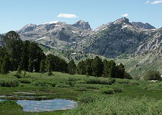
The Ruby Mountains Wilderness is a protected wilderness area in the Ruby Mountains of Elko County, Nevada, United States. It covers an area of approximately 90,000 acres (36,000 ha), and is administered by the Humboldt–Toiyabe National Forest.

Interstate 80 (I-80) traverses the northern portion of the US state of Nevada. The freeway serves the Reno metropolitan area and passes through the towns of Fernley, Lovelock, Winnemucca, Battle Mountain, Carlin, Elko, Wells, and West Wendover on its way through the state.

State Route 221 is a state highway in Elko County, Nevada. The route, concurrent with Interstate 80 Business follows Chestnut Street in the city of Carlin. The highway was once part of the former route of State Route 1 and former U.S. Route 40 (US 40).

State Route 227, most of which is more commonly known locally as Lamoille Highway, is a 20.134-mile-long (32.403 km) state highway in Elko County in northeastern Nevada.

Emigrant Pass is a mountain pass in Eureka County, Nevada, United States. It originally carried the California Trail over the Emigrant Hills of northern Eureka County, reaching a peak elevation of 6,125 feet (1,867 m). Interstate 80 now follows the California Trail's route over the pass.
Satview Broadband is privately owned cable television Multiple System Operator in the United States, with franchise cable television systems in the State of Colorado and Nevada. Satview offers Video, High-Speed Internet and Telephone Service in Topaz Lake, Wells and Carlin Nevada. Its systems in Battle Mountain, Elko were sold to Zito Media. Its systems in Utah were divisted in 2010 and New Mexico were divested in 2015. The operator serves mainly rural towns and cities. It has cable franchises in Elko and Douglas, counties in Nevada. and has Cable systems in the State of Colorado.
The Feather River Route is a rail line that was built and operated by the Western Pacific Railroad. It was constructed between 1906 and 1909, and connects the cities of Oakland, California, and Salt Lake City, Utah. The line was built to compete with the Southern Pacific Railroad, which at the time held a nearly complete monopoly on Northern California rail service. The route derives its name from its crossing of the Sierra Nevada, where it follows both the North and Middle Forks of the Feather River. The route is famous for its impressive engineering qualities and its considerable scenic value. All of the route is now owned and operated by the Union Pacific Railroad; however, the Union Pacific has transferred significant portions of the route to other lines. The portion still called the Feather River Route by the Union Pacific runs from the California Central Valley to Winnemucca, Nevada and has been divided into three subdivisions named the Sacramento, Canyon and Winnemucca subdivisions.

Halleck is an unincorporated community in central Elko County, Nevada, United States.

The Carlin Tunnel is a collective name for a set of four tunnel bores in the Humboldt River's Carlin Canyon, east of Carlin in Elko County, Nevada, United States. The two railroad bores were constructed for different purposes at different times, while the two highway bores were constructed concurrently, all with the goal of bypassing a sharp bend in the river. Currently, two of the bores carry Interstate 80, while the other two bores carry Union Pacific Railroad's Overland Route and Central Corridor. Bridges over the Humboldt River are adjacent to both portals of three tubes, including the two freeway bores and one of the railroad bores.

On August 12, 1939, the City of San Francisco train derailed outside of Harney, Nevada, United States, killing 24 and injuring 121 passengers and crew. The derailment was caused by sabotage of the tracks. Despite a manhunt, reward offers, and years of investigation by the Southern Pacific Railroad (SP), the case remains unsolved.
The Elko Subdivision is a railway line in Nevada owned and operated by the Union Pacific Railroad running from Weso to the freight yard in Elko. It is part of both the Overland Route and the Central Corridor. The line generally follows the Humboldt River and has several small tunnels while traversing the Palisade and Carlin Canyons, the longest tunnel is called the Carlin Tunnel.


