
Mount Monadnock, or Grand Monadnock, is a mountain in the town of Jaffrey, New Hampshire. It is the most prominent mountain peak in southern New Hampshire and is the highest point in Cheshire County. It lies 38 miles (61 km) southwest of Concord and 62 miles (100 km) northwest of Boston. At 3,165 feet (965 m), Mount Monadnock is nearly 1,000 feet (305 m) higher than any other mountain peak within 30 miles (48 km) and rises 2,000 feet (610 m) above the surrounding landscape. Monadnock's bare, isolated, and rocky summit provides expansive views. It is known for being featured in the writings of Ralph Waldo Emerson and Henry David Thoreau.

Mount Hood, also known as Wy'east, is an active stratovolcano in the Cascade Range and is a member of the Cascade Volcanic Arc. It was formed by a subduction zone on the Pacific Coast and rests in the Pacific Northwest region of the United States. It is located about 50 mi (80 km) east-southeast of Portland, on the border between Clackamas and Hood River counties, and forms part of the Mount Hood National Forest. Much of the mountain outside the ski areas is part of the Mount Hood Wilderness. With a summit elevation of 11,249 ft, it is the highest mountain in the U.S. state of Oregon and is the fourth highest in the Cascade Range. Ski areas on the mountain include Timberline Lodge ski area which offers the only year-round lift-served skiing in North America, Mount Hood Meadows, Mount Hood Skibowl, Summit Ski Area, and Cooper Spur ski area. Mt. Hood attracts an estimated 10,000 climbers a year.

Mount Adams, known by some Native American tribes as Pahto or Klickitat, is an active stratovolcano in the Cascade Range. Although Adams has not erupted in more than 1,000 years, it is not considered extinct. It is the second-highest mountain in Washington, after Mount Rainier.

The Barlow Road is a historic road in what is now the U.S. state of Oregon. It was built in 1846 by Sam Barlow and Philip Foster, with authorization of the Provisional Legislature of Oregon, and served as the last overland segment of the Oregon Trail. Its construction allowed covered wagons to cross the Cascade Range and reach the Willamette Valley, which had previously been nearly impossible. Even so, it was by far the most harrowing 100 miles (160 km) of the nearly 2,000-mile (3,200 km) Oregon Trail.

Beacon Mountain, locally Mount Beacon, is the highest peak of Hudson Highlands, located south of City of Beacon, New York, in the Town of Fishkill. Its two summits rise above the Hudson River behind the city and can easily be seen from Newburgh across the river and many other places in the region. The more accessible northern peak, at 1,516 feet (462 m) above sea level, has a complex of radio antennas on its summit; the 1,595 feet (486 m) southern summit has a fire lookout tower, which was built in 1931.

The Bull of the Woods Wilderness is a wilderness area located in the Mount Hood National Forest in the northwestern Cascades of Oregon, United States. It was created in 1984 and consists of 37,607 acres (15,219 ha) including prime low-elevation old-growth forest, about a dozen lakes of at least 1-acre (4,000 m2) and many large creeks and streams. Adjacent areas, including Opal Creek Wilderness to the west, create a pristine area of nearly 84 square miles (218 km2). There are seven trails that access the wilderness area with an additional seven trails within the protection boundaries themselves. Combined the system provides 75 miles (121 km) of challenging terrain for both pedestrian and equestrian recreation. The name of the peak and thus the wilderness area comes from logging jargon in which the "bull of the woods" was the most experienced logging foreman in an operation.

Diamond Peak is a volcano in Klamath and Lane counties of central Oregon in the United States. It is a shield volcano, though it might also be considered a modest stratocone. Diamond Peak forms part of the Cascade Volcanic Arc, a segment of the Cascade Range in western North America extending from southern British Columbia through Oregon to Northern California. Reaching an elevation of 8,748 feet (2,666 m), the mountain is located near Willamette Pass in the Diamond Peak Wilderness within the Deschutes and Willamette national forests. Surrounded by coniferous forest and visible in the skyline from foothills near Eugene, Diamond Peak offers a few climbing routes and can be scrambled. Diamond Peak is one of Oregon's Matterhorns.

Kearsarge North is a mountain located about 4 miles (6 km) northeast of North Conway, Carroll County, New Hampshire, United States. The U.S. Board on Geographic Names accepted the name "Pequawket Mountain" in 1915 but it was renamed Kearsarge North in 1957. The Pequawket are a subdivision of the Abenaki people who formerly lived in the area. It is sometimes referred to as Mount Kearsarge, a name officially assigned to a mountain in Merrimack County.

The Sky Lakes Wilderness is a wilderness area located in the Rogue River–Siskiyou and Fremont–Winema national forests in the southern Cascade Range of Oregon in the United States. It comprises 116,300 acres (47,100 ha), of which 75,695 acres (30,633 ha) are in the Rogue River–Siskiyou National Forest and 40,605 acres (16,432 ha) are in the Fremont–Winema National Forest. It was established in 1984 under the Wilderness Act of 1964.

Maiden Peak is a steep-sided shield volcano in the Cascade Range of central Oregon. It is the highest point in the 43-mile (69 km) distance between Mount Bachelor and Diamond Peak. Ice Age glaciers carved a large cirque into the northeast flank of the mountain, exposing magma which hardened in the volcano's conduits to form the numerous rock pinnacles now found in the upper part of the cirque.

Black Crater is a shield volcano in the Western Cascades in Deschutes County, Oregon. Located near McKenzie Pass, the volcano has a broad conical shape with gentle slopes. The volcano likely formed during the Pleistocene and has not been active within the last 50,000 years. Eruptive activity at the volcano produced mafic lava flows made of basaltic andesite and olivine basalt; it also formed a number of cinder cones. A normal fault occurs on the western side of the volcano, trending north–south. The volcano has been eroded by glaciers, which carved a large cirque into the northeastern flank of the mountain, forming its current crater.

Yamsay Mountain is a large shield volcano in the Cascade Range of south-central Oregon, located about 35 miles (56 km) east of Crater Lake on the border between Klamath County and Lake County. It is part of the Cascade Volcanic Arc but is located in a mountain range 30 to 50 miles behind the main Cascade volcanic front. The best known members of this enigmatic arc are the massive shields of Newberry Volcano, about 55 miles (89 km) farther north in Oregon, and Medicine Lake Volcano, about 80 miles (130 km) south in Northern California. Yamsay is the second highest volcano in the eastern arc, almost 300 feet (90 m) higher than Newberry and Medicine Lake.

Pelican Butte is a steep-sided shield volcano in the Cascade Range of southern Oregon. It is located 28 miles (45 km) due south of Crater Lake and 12 miles (19 km) northeast of Mount McLoughlin. Pelican Butte is the most prominent shield volcano in the southern Oregon Cascades and has a large volume at 4.8 cubic miles (20 km3), making it one of the bigger Quaternary volcanoes in the region, approaching the size of some of the range's stratovolcanoes. While still part of the Cascades, Pelican Butte is disconnected from the main axis, forming above faults along the eastern border of the range. Pelican Butte is part of the Quaternary Mount McLoughlin Reach, a volcanic vent zone that runs from the volcano to Aspen Lake, encompassing 33 vents over an area of 357 square miles (925 km2). Ice age glaciers carved a large cirque into the northeast flank of the mountain, but despite this erosion, its original shape is largely preserved. Several proposals have been made over the last few decades for the development of a ski area on this flank, but none have been implemented.
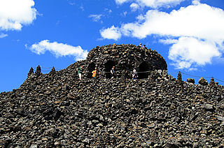
Dee Wright Observatory is an observation structure at the summit of McKenzie Pass in the Cascade Mountains of Oregon. The structure is an open shelter constructed with lava stone. It is located in the midst of a large lava flow, and offers an exceptional view of numerous Cascade peaks.

The Musick Guard Station is a rustic cabin located in the Umpqua National Forest in western Oregon, United States. It was originally built to house fire crews assigned to patrol the surrounding National Forest. In the 1990s, the United States Forest Service began renting Musick Guard Station to recreational visitors. The Musick Guard Station is listed on the National Register of Historic Places.

Hager Mountain is a volcanic peak in Oregon in the northwest corner of the Basin and Range Province in the United States. The mountain is located south of the small unincorporated community of Silver Lake in south-central Oregon, and it is in the Fremont–Winema National Forest. On the summit, there is a fire lookout operated during the summer and fall by the United States Forest Service. There are several hiking trails that lead to the lookout station.

The Oregon Skyline Trail is a long-distance trail in the Cascade Mountains of Oregon. The trail extends 428 miles (689 km) from Cascade Locks on the Columbia River south to Siskiyou Summit near the Oregon-California border. The century-old trail is a foot and equestrian path that passes through nine wilderness areas, Crater Lake National Park, and Cascade-Siskiyou National Monument. Historically known as the Oregon Skyline Trail or Skyline Trail, the entire length of the trail was incorporated into the Pacific Crest National Scenic Trail in 1968.

Crane Mountain is in the Warner Mountain range and is the tallest peak in Lake County, Oregon, U.S. It is located southeast of Lakeview in south-central Oregon, near the northwest corner of the Basin and Range Province of the western United States. The mountain is in the Fremont section of the Fremont–Winema National Forest. There was a United States Forest Service fire lookout located near the summit which was removed in 1972. The Crane Mountain National Recreation Trail runs north and south along the crest of the mountain.

Cone Peak is the second highest mountain in the Santa Lucia Range in the Ventana Wilderness of the Los Padres National Forest. It rises nearly a vertical mile only 3 miles (4.8 km) from the coast as the crow flies. This is one of the steepest gradients from ocean to summit in the contiguous United States. The average gradient from sea level to summit is around 33%, which is steeper than the average gradient from Owens Valley to the summit of Mount Whitney. Near the mountain summit, the oak woodland and chaparral transitions to a pine forest with a few rare Santa Lucia Firs. Junipero Serra Peak at 5,865 feet (1,788 m) is the highest peak in the coastal region.
Bachelor Mountain is a mountain located in Linn County, Oregon.
