Castelnuovo Parano

Last updated
Castelnuovo Parano
Comune
Comune di Castelnuovo Parano
Castelnuovo Parano-Stemma.png
Coat of arms
Italy provincial location map 2015.svg
Red pog.svg
Castelnuovo Parano
Location of Castelnuovo Parano in Italy
Coordinates: 41°22′N13°45′E / 41.367°N 13.750°E / 41.367; 13.750
Country Italy
Region Lazio
Province Frosinone (FR)
Frazioni Casali, Terra, Valli-Sant'Antonio, Cisterna, Pimpinelli
Government
  Mayor Oreste De Bellis
Area
  Total 9.88 km2 (3.81 sq mi)
Elevation 310 m (1,020 ft)
Population (28 February 2017) [1]
  Total 884
  Density 89/km2 (230/sq mi)
Demonym(s) Castelnovesi
Time zone CET (UTC+1)
  Summer (DST) CEST (UTC+2)
Postal code03040
Dialing code 0776
Patron saint St. Maurus
Saint day 15 January
Website Official website

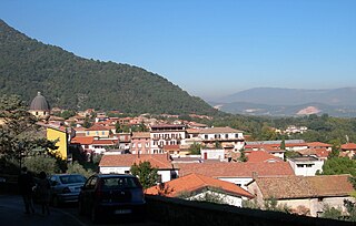
Castelnuovo Parano is a comune (municipality) in the province of Frosinone in the Italian region Lazio, located about 120 kilometres (75 miles) southeast of Rome and about 45 kilometres (28 mi) southeast of Frosinone.

<i>Comune</i> third-level administrative divisions of the Italian Republic

The comune is a basic administrative division in Italy, roughly equivalent to a township or municipality.

Province of Frosinone Province of Italy

The Province of Frosinone is a province in the Lazio region of Italy, with 91 comuni. Its capital is the city of Frosinone. It has an area of 3,247 square kilometres (1,254 sq mi) and a total population of 493,605 (2016).

Italy republic in Southern Europe

Italy, officially the Italian Republic, is a country in Southern and Western Europe. Located in the middle of the Mediterranean Sea, Italy shares open land borders with France, Switzerland, Austria, Slovenia and the enclaved microstates San Marino and Vatican City. Italy covers an area of 301,340 km2 (116,350 sq mi) and has a largely temperate seasonal and Mediterranean climate. With around 61 million inhabitants, it is the fourth-most populous EU member state and the most populous country in Southern Europe.

It originates from a castle built here in 1059 by abbot Desiderius of Montecassino to defend the area between Fratte and Traetto. The area was severely damaged during World War II due to its position across the Gustav Line. After the end of the conflict, much of the population emigrated.

Ausonia, Lazio Comune in Lazio, Italy

Ausonia is a town and comune in southern Lazio, central Italy. It takes its name from the Ausones/Aurunci, whose ancient town Ausona, located nearby, was destroyed by the Romans in 314 BC. In the Middle Ages it was known as Fratte.

World War II 1939–1945 global war

World War II, also known as the Second World War, was a global war that lasted from 1939 to 1945. The vast majority of the world's countries—including all the great powers—eventually formed two opposing military alliances: the Allies and the Axis. A state of total war emerged, directly involving more than 100 million people from over 30 countries. The major participants threw their entire economic, industrial, and scientific capabilities behind the war effort, blurring the distinction between civilian and military resources. World War II was the deadliest conflict in human history, marked by 50 to 85 million fatalities, most of whom were civilians in the Soviet Union and China. It included massacres, the genocide of the Holocaust, strategic bombing, premeditated death from starvation and disease, and the only use of nuclear weapons in war.

Related Research Articles

Acquafondata Comune in Lazio, Italy

Acquafondata is a comune (municipality) in the Province of Frosinone in the Italian region Lazio, located in the Monti della Meta area, about 130 kilometres (81 mi) southeast of Rome and about 50 kilometres (31 mi) east of Frosinone.

Arnara Comune in Lazio, Italy

Arnara is a comune (municipality) in the Province of Frosinone in the Italian region Lazio, located about 80 kilometres (50 mi) southeast of Rome and about 6 kilometres (4 mi) southeast of Frosinone.

Castrocielo Comune in Lazio, Italy

Castrocielo is a comune (municipality) in the province of Frosinone in the Italian region Lazio, located about 110 kilometres (68 mi) southeast of Rome and about 30 kilometres (19 mi) southeast of Frosinone.

Colfelice Comune in Lazio, Italy

Colfelice is a comune (municipality) in the Province of Frosinone in the Italian region Lazio, located about 100 kilometres (62 mi) southeast of Rome and about 25 kilometres (16 mi) southeast of Frosinone.

Falvaterra Comune in Lazio, Italy

Falvaterra is a comune (municipality) in the Province of Frosinone in the Italian region Lazio, located about 100 kilometres (62 mi) southeast of Rome and about 20 kilometres (12 mi) southeast of Frosinone.

Giuliano di Roma Comune in Lazio, Italy

Giuliano di Roma is a comune (municipality) in the province of Frosinone in the Italian region Lazio, located about 80 kilometres (50 mi) southeast of Rome and about 12 kilometres (7 mi) southwest of Frosinone.

Pastena Comune in Lazio, Italy

Pastena is a comune (municipality) in the Province of Frosinone in the Italian region Lazio, located about 90 kilometres (56 mi) southeast of Rome and about 20 kilometres (12 mi) southeast of Frosinone.

Piedimonte San Germano Comune in Lazio, Italy

Piedimonte San Germano is a comune (municipality) in the province of Frosinone in the Italian region of Lazio, located in the Liri River valley about 110 kilometres (68 mi) southeast of Rome and about 35 kilometres (22 mi) southeast of Frosinone.

Pofi Comune in Lazio, Italy

Pofi is a comune (municipality) of about 4,200 inhabitants in the province of Frosinone in the Italian region Lazio, located about 80 kilometres (50 mi) southeast of Rome and about 9 kilometres (6 mi) southeast of Frosinone.

Ripi Comune in Lazio, Italy

Ripi is a comune (municipality) in the Province of Frosinone in the Italian region Lazio, located about 80 kilometres (50 mi) southeast of Rome and about 7 kilometres (4 mi) east of Frosinone. As of 31 December 2004, it had a population of 5,390 and an area of 31.4 square kilometres (12.1 sq mi).

Rocca dArce Comune in Lazio, Italy

Rocca d'Arce is a comune (municipality) in the Province of Frosinone in the Italian region Lazio, located about 100 kilometres (62 mi) southeast of Rome and about 20 kilometres (12 mi) southeast of Frosinone.

San Giorgio a Liri Comune in Lazio, Italy

San Giorgio a Liri is a comune (municipality) in the Province of Frosinone in the Italian region Lazio, located about 120 kilometres (75 mi) southeast of Rome and about 45 kilometres (28 mi) southeast of Frosinone.

Supino Comune in Lazio, Italy

Supino is a comune (municipality) in the Province of Frosinone in the Italian region Lazio, located about 70 kilometres (43 mi) southeast of Rome and about 10 kilometres (6 mi) west of Frosinone.

Torrice Comune in Lazio, Italy

Torrice is a comune (municipality) in the Province of Frosinone in the Italian region Lazio, located about 80 kilometres (50 mi) southeast of Rome and about 4 kilometres (2.5 mi) east of Frosinone.

Vallecorsa Comune in Lazio, Italy

Vallecorsa is a comune (municipality) in the Province of Frosinone in the Italian region Lazio, located about 90 kilometres (56 mi) southeast of Rome and about 20 kilometres (12 mi) south of Frosinone, in the Monti Ausoni area.

Vallemaio Comune in Lazio, Italy

Vallemaio is a comune (municipality) in the Province of Frosinone in the Italian region Lazio, located about 120 kilometres (75 mi) southeast of Rome and about 50 kilometres (31 mi) southeast of Frosinone.

Villa Latina Comune in Lazio, Italy

Villa Latina is a comune (municipality) in the Province of Frosinone in the Italian region Lazio, located about 120 kilometres (75 mi) southeast of Rome and about 40 kilometres (25 mi) east of Frosinone.

Villa Santa Lucia Comune in Lazio, Italy

Villa Santa Lucia is a comune (municipality) in the province of Frosinone in the Italian region Lazio, located about 110 kilometres (68 mi) southeast of Rome and about 35 kilometres (22 mi) southeast of Frosinone.

Villa Santo Stefano Comune in Lazio, Italy

Villa Santo Stefano is a comune (municipality) in the Province of Frosinone in the Italian region Lazio, located about 80 kilometres (50 mi) southeast of Rome and about 13 kilometres (8 mi) south of Frosinone.

Viticuso Comune in Lazio, Italy

Viticuso is a comune (municipality) in the Province of Frosinone in the Italian region Lazio, located about 130 kilometres (81 mi) southeast of Rome and about 50 kilometres (31 mi) east of Frosinone.

References

  1. All demographics and other statistics: Italian statistical institute Istat.