Ceccano | |
|---|---|
| Comune di Ceccano | |
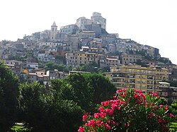 View of Ceccano | |
 Coat of arms | |
 Ceccano Location of Ceccano in Italy  Ceccano Ceccano (Lazio) | |
| Coordinates: 41°34′N13°20′E / 41.567°N 13.333°E | |
| Country | Italy |
| Region | Lazio |
| Province | Frosinone (FR) |
| Government | |
| • Mayor | Roberto Caligiore |
| Area | |
• Total | 61.06 km2 (23.58 sq mi) |
| Elevation | 200 m (660 ft) |
| Population (31 October 2020) [2] | |
• Total | 22,367 |
| • Density | 366.3/km2 (948.7/sq mi) |
| Demonym | Ceccanesi |
| Time zone | UTC+1 (CET) |
| • Summer (DST) | UTC+2 (CEST) |
| Postal code | 03023 |
| Dialing code | 0775 |
| Patron saint | St. John the Baptist |
| Saint day | 24 June |
| Website | Official website |
Ceccano is a town and comune in the province of Frosinone, Lazio, central Italy, in the Latin Valley.