Arnara is a comune (municipality) in the Province of Frosinone in the Italian region Lazio, located about 80 kilometres (50 mi) southeast of Rome and about 6 kilometres (4 mi) southeast of Frosinone.
Belmonte Castello is a comune (municipality) in the Province of Frosinone in the Italian region Lazio, located about 120 kilometres (75 mi) southeast of Rome and about 40 kilometres (25 mi) east of Frosinone.
Casalvieri is a comune (municipality) in the Province of Frosinone in the Italian region Lazio, located about 110 kilometres (68 mi) southeast of Rome and about 30 kilometres (19 mi) east of Frosinone.
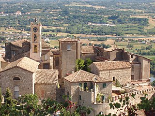
Castelliri is a comune (municipality) of c. 3,500 inhabitants in the province of Frosinone in the Italian region Lazio, located in the valley of the Liri, about 90 kilometres (56 mi) southeast of Rome and about 20 kilometres (12 mi) northeast of Frosinone.

Castrocielo is a comune (municipality) in the province of Frosinone in the Italian region Lazio, located about 110 kilometres (68 mi) southeast of Rome and about 30 kilometres (19 mi) southeast of Frosinone.

Castro dei Volsci is a comune (municipality) of 4,702 inhabitants in the Province of Frosinone in the Italian region Lazio, located about 90 kilometres (56 mi) southeast of Rome and about 14 kilometres (9 mi) southeast of Frosinone.
Colfelice is a comune (municipality) in the Province of Frosinone in the Italian region Lazio, located about 100 kilometres (62 mi) southeast of Rome and about 25 kilometres (16 mi) southeast of Frosinone.
Falvaterra is a comune (municipality) in the Province of Frosinone in the Italian region Lazio, located about 100 kilometres (62 mi) southeast of Rome and about 20 kilometres (12 mi) southeast of Frosinone.

Morolo is a comune (municipality) in the Province of Frosinone in the Italian region Lazio, located about 70 kilometres (43 mi) southeast of Rome and about 12 kilometres (7 mi) west of Frosinone.

Pastena is a comune (municipality) in the Province of Frosinone in the Italian region Lazio, located about 90 kilometres (56 mi) southeast of Rome and about 20 kilometres (12 mi) southeast of Frosinone.
Piedimonte San Germano is a comune (municipality) in the province of Frosinone in the Italian region of Lazio, located in the Liri River valley about 110 kilometres (68 mi) southeast of Rome and about 35 kilometres (22 mi) southeast of Frosinone.
Ripi is a comune (municipality) in the Province of Frosinone in the Italian region Lazio, located about 80 kilometres (50 mi) southeast of Rome and about 7 kilometres (4 mi) east of Frosinone.
San Giorgio a Liri is a comune (municipality) in the Province of Frosinone in the Italian region Lazio, located about 120 kilometres (75 mi) southeast of Rome and about 45 kilometres (28 mi) southeast of Frosinone.

San Giovanni Incarico is a comune (municipality) in the Province of Frosinone in the Italian region Lazio, located about 100 kilometres southeast of Rome and about 20 km (12 mi) southeast of Frosinone.
San Vittore del Lazio is a comune (municipality) in the Province of Frosinone in the Italian region Lazio, located about 130 kilometres (81 mi) southeast of Rome and about 50 kilometres (31 mi) southeast of Frosinone.
Supino is a comune (municipality) in the Province of Frosinone in the Italian region Lazio, located about 70 kilometres (43 mi) southeast of Rome and about 10 kilometres (6 mi) west of Frosinone.
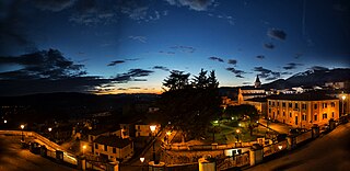
Torrice is a comune (municipality) in the Province of Frosinone in the Italian region of Lazio, located about 80 kilometres (50 mi) southeast of Rome and about 4 kilometres (2.5 mi) east of Frosinone.

Vallemaio is a comune (municipality) in the Province of Frosinone in the Italian region Lazio, located about 120 kilometres (75 mi) southeast of Rome and about 50 kilometres (31 mi) southeast of Frosinone.
Villa Latina is a comune (municipality) in the Province of Frosinone in the Italian region Lazio, located about 120 kilometres (75 mi) southeast of Rome and about 40 kilometres (25 mi) east of Frosinone.
Villa Santa Lucia is a comune (municipality) in the province of Frosinone in the Italian region Lazio, located about 110 kilometres (68 mi) southeast of Rome and about 35 kilometres (22 mi) southeast of Frosinone.


