Parkway Village is a home rule-class city in Jefferson County, Kentucky, United States, and a part of the Louisville Metro government. It was developed in the 1920s and incorporated in 1941. The population was 650 at the 2010 census.

Dunlap is an unincorporated community in Fresno County, California. It lies at an elevation of 1,919 ft (585 m). It has a population of 131. It is located approximately 38 miles (61 km) east of Fresno. In the 1800s Dunlap was a rest stop for passengers of the stage coach and a location for a change of horses.
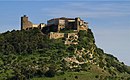
Juromenha is a town in southeastern Portugal, near the border with Spain. It is part of Alandroal Municipality.

Bogota is an unincorporated community in Smallwood Township, Jasper County, Illinois, United States.
Five Mile Terrace is an unincorporated community in El Dorado County, California. It is located 2 miles (3.2 km) west of Camino, at an elevation of 2933 feet.

KJVC is a radio station airing a country music format licensed to Mansfield, Louisiana, broadcasting on 92.7 MHz FM. The station is owned by Leon Hunt.

Campbelltown is an unincorporated community in Patoka Township, Pike County, in the U.S. state of Indiana.
Lyra is an unincorporated community in Scioto County, in the U.S. state of Ohio.

Prospect Island is a small island in the San Joaquin River delta, in California. It is part of Solano County, and managed by Reclamation District 1667. Its coordinates are 38.2463030°N 121.6655110°W. It appears on a 1952 USGS map; by 1978, survey maps show it cut diagonally by the Sacramento River Deep Water Ship Channel.

French Island is a small island in the Sacramento–San Joaquin River Delta. It is part of Solano County, California. Its coordinates are 38°15′51″N121°41′38″W, and the United States Geological Survey measured its elevation as 0 ft (0 m) in 1981. It appears on USGS maps in 1952 and 1978, with the same shape and elevation.

Headreach Island is a small island in the Sacramento–San Joaquin River Delta. It is part of San Joaquin County, California. Its coordinates are 38°01′55″N121°29′04″W, and the United States Geological Survey measured its elevation as 7 ft (2.1 m) in 1981. It appears on a 1952 USGS map of the area.

Ida Island is a small island in the Sacramento–San Joaquin River Delta. It is part of Sacramento County, California. Its coordinates are 38°10′14″N121°38′12″W, and the United States Geological Survey measured its elevation as 3 ft (0.91 m) in 1981. It appears on a 1978 USGS map of the area.

Little Venice Island is a small island in the Sacramento–San Joaquin River Delta. It is part of San Joaquin County, California. Its coordinates are 38°03′02″N121°30′05″W, and the United States Geological Survey measured its elevation as 0 ft (0 m) in 1981. It appears on a 1952 USGS map of the area.

Long Island is a small island in the Sacramento–San Joaquin River Delta. It is part of Sacramento County, California. Its coordinates are 38°10′01″N121°37′30″W, and the United States Geological Survey measured its elevation as 7 ft (2.1 m) in 1981. It appears on 1978 USGS maps of the area.

Mallard Island is a small island in Suisun Bay, at the confluence of the Sacramento and San Joaquin rivers. It is part of Contra Costa County, California. Its coordinates are 38°02′31″N121°55′07″W, and the United States Geological Survey measured its elevation as 3 ft (0.91 m) in 1981. It appears in a 1953 USGS map of the area.

Spud Island is a small island in the Sacramento–San Joaquin River Delta. It is part of San Joaquin County, California. Its coordinates are 38°00′27″N121°27′26″W, and the United States Geological Survey measured its elevation as 13 ft (4.0 m) in 1981. It appears on a 1952 USGS map of the area.

Tule Island is a small island in the Sacramento–San Joaquin River Delta. It is part of San Joaquin County, California. Its coordinates are 38°01′41″N121°28′39″W, and the United States Geological Survey measured its elevation as 33 ft (10 m) in 1981. It appears on a 1952 USGS map of the area.

Ward Island is a small island in the Sacramento–San Joaquin River Delta. It is part of San Joaquin County, California. Its coordinates are 38°02′30″N121°30′09″W, and the United States Geological Survey measured its elevation as 7 ft (2.1 m) in 1981. It appears on a 1952 USGS map of the area.

Little Hastings Tract is a mostly submerged island in the Sacramento–San Joaquin River Delta. It is in Solano County, California. Its coordinates are 38°15′02″N121°41′32″W, and the United States Geological Survey gave its elevation as 0 ft (0 m) in 1981. It appears, above water, on a 1978 USGS map.
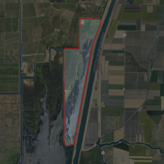
The Little Holland Tract is a partially submerged island in the Sacramento–San Joaquin River Delta, in Yolo County, California. Its coordinates are 38°19′27″N121°39′20″W, and the United States Geological Survey gave its elevation as 13 ft (4.0 m) in 1981. It appears on a 1952 USGS map as a large rectangular tract; by 1978, survey maps show it cut diagonally by the Sacramento River Deep Water Ship Channel.