Castle of Cola

Last updated
Castle of Cola
Castelo de Cola
Beja, Baixo Alentejo, Alentejo in  Portugal
Castle of Cola
Location of the ruins of the castle within the municipality of Ourique, district of Beja
Coordinates 37°34′43.51″N8°18′1.69″W / 37.5787528°N 8.3004694°W / 37.5787528; -8.3004694
TypeCastle
Site information
OwnerPortuguese Republic
OperatorDRCAlentejo (Portaria 829/2009; DR, Série II, 163, 24 August 2009)
Open to
the public
Public
Site history
Built Bronze Age
Materials Masonry, Schist

Castle of Cola (Portuguese : Castelo de Cola) is an Iron Age residence and Islamic redoubt in the Portuguese Alentejo, classified as a National Monument. The castro is part of a larger archaeological park of Castro da Cola, that includes various Megalithic and Chalcolithic monuments, including necropolises of the Bronze and Iron Ages. The Castro-era polygonal plan, included reinforced blocks, with an entrance controlled by tower. The remaining defensive structure was circled by walls, with still exist, on the neighboring pasture-lands protecting the castle.

Contents

History

Fortified medieval settlement of Cola, a castro later converted to Islamic outpost Castelo da Cola.JPG
Fortified medieval settlement of Cola, a castro later converted to Islamic outpost

The construction of the ancient occurred, and human occupation fixed itself on this site, around the beginning of the Bronze Age.

During the period of Islamic influence within the Iberian peninsula, the castro was reinforced to serve as an outpost. The fortification controlled one of the principal routes of passage into the Algarve. Of the artifacts discovered there are objects dating to the pre- and proto-cultural episodes of the region, including: polished stone axes, fragments of Iron Age vessels, rural ceramics, glass beads, gold, needle bone, bronze bracelets, drills, firing pins, spheroids; historical objects: Roman-Visigoth ceramics, Arabic and Portuguese Medieval metal objects (screws, cossoiros, buckles, keys, rings, etc.), stone objects (millstones, spheroids throwing, firing pins), hewn Roman and Visigothic stones, Arab tombstones, coins, Roman lamps.

The site was abandoned during the 14th century, based on the research of Abel Viana. Yet, this is contradicted by Rosa Varela Gomes, who suggests that that abandonment of the site occurred sometime between the 15th and 16th century.

Excavations on the site were realized in 1960, under the direction of Abel Viana. During this period the walls of the southeast corner were consolidated (1961) Further investigations and reinforcement of the northern parts of the castle were accomplished in 1962, followed once again in 1963 by work completed by Abel Viana.

In 1999, it was included within the Programa de Valorização e Divulgação Turística (Tourist Valorization and Appreciation Program), by the Ministry of Commerce and Tourism and Secretary of State for Culture, and included as part of the archaeological itineraries for the Alentejo and Algarve regions. In order to improve tourist visits, a new interpretative center and reception area was constructed between 1999 and 2000, by architect Sofia Salema.

In 2001, archaeological excavations were carried out on the site.

Architecture

The castro is located in a rural environment, on the crest of a mountain 201 metres (659 ft) above the river valley, along the Ribeira do Marchicão and near the Rio Mira. The landscape, which is 70 metres (230 ft) above the Rio Mira, is protected by walls of the fortification to the southwest and northeast. Near the site is the Church of Nossa Senhora da Cola, an annual destination for pilgrims. Cola is part of an archaeological circuit that covers an area of 15 kilometres (9.3 mi), part of 23 stations from the Neolithic and Middle Ages, including the Chalcolithic settlement of Cortadouro, the Megalithic monuments of Fernão Vaz I and II, as well as the Tholos da Nora Velha, the necropolises of Porto de Lages, Pego da Sobreira, Fernão Vaz and Vaga da Cascalheira.

The plan of the castle consists of an irregular 125 metres (410 ft)-long polygon, with 60 metres (200 ft) width, consisting of 2.4 metres (7.9 ft) thick walls, although in some areas this width was between 5–6 metres (16–20 ft). These walls were reinforced by unequal-sized rectangular blocks.

A main gate is located on the south wall, defended by a large tower, of thicker construction.

A thick wall divides the courtyard into two zones to the south. Here a cistern, dug from the rock, 3.79×2.70×2.20 metres (12.4×8.9×7.2 ft), is located, with semi-circular vaulted ceiling and square nozzole.

The floor within the castle consists of a mixture of sand, gravel and pebbles, with vestiges of rectangular houses located in various locations.

Related Research Articles

<span class="mw-page-title-main">Beja, Portugal</span> Municipality in Alentejo, Portugal

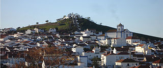
Beja is a city and a municipality in the Alentejo region, Portugal. The population in 2011 was 35,854, in an area of 1,146.44 km2 (442.64 sq mi). The city proper had a population of 21,658 in 2001.

<span class="mw-page-title-main">Castle of Salir</span> Castle in southern Portugal

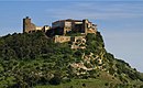
The Castle of Salir is an Almohad fortress, located in the civil parish of the same name, 16 kilometres from the municipality seat of Loulé in the Portuguese Algarve.

<span class="mw-page-title-main">Castro Verde</span> Municipality in Alentejo, Portugal

Castro Verde is a town and a municipality of the Alentejo region of Portugal. The population in 2011 was 7,276, in an area of 569.44 km2. Castro Verde is situated in the Baixo Alentejo subregion, within a territory known locally as the Campo Branco . The municipality can be recognized by the local municipal markers along its borders, that appear within its borders to denote its reference as A Window on the Plains; municipal markers appear as stylized house profiles, with an exaggerated window that allows the visitor to see through into the panorama.

<span class="mw-page-title-main">Roman ruins of São Cucufate</span>

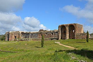
The Roman ruins of São Cucufate is a Romanesque archaeological site, located on the ruins of a Roman-era agricultural farm in the civil parish of Vila de Frades, in the municipality of Vidigueira, in the southern Alentejo, Portugal. The convent, which dates back to Middle Ages, was dedicated to the martyred saint Cucuphas.

<span class="mw-page-title-main">Escoural Cave</span> Cave and archaeological site in Portugal

The Prehistoric Rock-Art Site of Escoural Cave is a structure known for its Paleolithic-era rock-art and funerary burial site, located in the Portuguese municipality of Montemor-o-Novo, in the civil parish of Santiago do Escoural.

<span class="mw-page-title-main">Castle of Viana do Alentejo</span> Gothic castle in Viana do Alentejo, Alentejo, Portugal

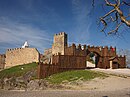
The Castle of Viana do Alentejo is a gothic castle constructed during the reconquest and settlement of the central region of the Portuguese Alentejo, located in the parish of Viana do Alentejo, municipality of the same name. Although a relatively low-profile design, in comparison to its contemporaries, the structure served the period of strife associated with expansion of Portuguese forces/authority into the southern Algarve.

<span class="mw-page-title-main">Castle of Beja</span> Medieval castle in Beja, Portugal

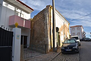
The Castle of Beja is a medieval castle in the civil parish of Beja, municipality of Beja, Portuguese district of Beja.

<span class="mw-page-title-main">Castle of Aljustrel</span> Medieval castle in Aljustrel, Beja, Portugal

The Castle of Aljustrel is a Portuguese medieval castle in civil parish of Aljustrel e Rio de Moinhos, in the municipality of Aljustrel, in the district of Beja.

<span class="mw-page-title-main">Castro of Zambujal</span> Neolithic site in Portugal

The Castro of Zambujal is a Chalcolithic age archeological site in the municipality of Torres Vedras in the western litoral area of the Centro Region, Portugal. The Zambujal Castro is one of the most important Copper Age settlements in the peninsula of Lisbon, and whose culture lasted until the beginning of the agrarian periods of Iberian history. Apart from being the most northerly discovered Copper Age site in Portugal, it went through two main building phases: an import-oriented phase and the second associated with the Beaker culture.

<span class="mw-page-title-main">Torrão</span> Civil parish in Alentejo, Portugal

Torrão is a civil parish and town, in the municipality of Alcácer do Sal, in the Portuguese district of Setúbal, bordering on the districts of Évora and the Beja. It is crossed by the river Xarrama River. The population in 2011 was 2,295, in an area of 372.39 km2.

<span class="mw-page-title-main">Archaeological site of Cabeço do Vouga</span>

The Archaeological site of Cabeço do Vouga, also known as Castelium Marnelis, is an archaeological site in civil parish union of Trofa, Segadães e Lamas do Vouga, in the municipality of Águeda, in central Portugal. It is classified as a Property of Public Interest, and dates back to the Iron Age.

<span class="mw-page-title-main">Castle of Moura</span> Medieval castle in Moura, Beja, Portugal

The Castle of Moura is a Portuguese medieval castle in civil parish of Moura e Santo Amador, in the municipality of Moura, in the district of Beja.

<span class="mw-page-title-main">Castle of Noudar</span> Medieval castle in southern Portugal

The Castle of Noudar is a Portuguese medieval castle in the civil parish and municipality of Barrancos, in the district of Beja.

The Castro of Castelo Velho is a Chalcolithic settlement in the civil parish of Terena, municipality of Alandroal in the Alentejo Central area of the Portuguese Alentejo.

<span class="mw-page-title-main">Roman villa of Freiria</span>

The Roman villa of Freiria is a Roman villa in the civil parish of São Domingos de Rana, in the Portuguese municipality of Cascais.

<span class="mw-page-title-main">Roman ruins of Pisões</span>

The Roman Ruins of Pisões, is an important Roman villa rustica located in the civil parish of Beja in the municipality of Beja, in the Portuguese Alentejo, classified as a Imóvel de Interesse Público.

<span class="mw-page-title-main">Castro of Chibanes</span> Chalcolithic and Roman site in Portugal

The Castro of Chibanes is located in the Arrábida Nature Park, on the Serra do Louro, in the municipality of Palmela in the Setúbal District of Portugal, about 25 km (16 mi) south of the capital of Lisbon, which can be seen from the site. The Castro, or hill fort, is located at the top of the hill, naturally defended by a scarp to the south. It covers about one hectare and was first occupied in about 2900 BCE, during the Chalcolithic or Copper Age. It is registered as a Zona Especial de Protecção and also classified as a Sitio de Interesse Público.

A castro is a fortified settlement, usually pre-Roman, associated with the Celtic culture. These are frequently found in Portugal, usually in the North, but can also be found elsewhere. The word castro comes from the Latin castrum, which means "hill fort". The first Castros where just small residences with rudimentary stone walls.

<span class="mw-page-title-main">Citânia de Santa Luzia</span> Archaeological site in Paços de Ferreira, Portugal

The Citânia de Santa Luzia is an archaeological site of the Castro culture located in the Portuguese civil parish of Areosa in the municipality of Viana do Castelo. Its construction dates from the Iron Age, and it shows evidence of occupation during the Roman period. The Castro was first dug in 1876 by Joaquim Possidonio Narciso da Silva. Only about one third of the structures have been dug, with the remaining part being under or destroyed during the construction of the nearby hotel, church, and respective roads. The site also included a possibly medieval chapel dedicated to Saint Lucy which persisted, after some reconstructions, until 1926 when it was destroyed to give way to the Saint Lucy Church of Miguel Ventura Terra.

References