Peninsula extending northeast into Manila Bay from Noveleta in Cavite province in the Philippines
Aerial view (c. 1964) of the Cavite Peninsula as seen from the north with Manila Bay below and right of the picture. In the foreground is the former U.S. Naval Base Sangley Point, with Cavite City adjacent in the back. Cañacao Bay is immediately to the left of the naval base. Bacoor Bay is on the left center of the picture.
The Cavite Peninsula is a peninsula extending northeast into Manila Bay from the coastal town of Noveleta in Cavite province in the Philippines. The northern tip of the peninsula is geographically the northernmost part of the Province of Cavite.[1]
The peninsula is composed of the City of Cavite with a tiny southern portion part of the Municipality of Noveleta. The northernmost portion of the peninsula, called Sangley Point, was the location of the former U.S. Naval Station Sangley Point until 1971 when it was turned over to the Philippine government. It is now called the Danilo Atienza Air Base, a Philippine Air Force base.
Geography
The Cavite peninsula (lower left) in relation to the City of Manila (upper middle).
The peninsula is shaped like a human left hand starting from about the middle of the forearm with fingers forming a letter 'C'. Cañacao Bay is the body of water formed by the C-shaped upper peninsula. The thumb area was the historic old Port City of Cavite, the sister city and main seaport of the City of Manila. Because of deeper waters than the Port of Manila that was then located along the banks of the Pasig River, the Port of Cavite became the staging and receiving area for the Manila galleon trade from 1565 to 1815.[2]
The port city used to be an island connected by a causeway to Barangay San Roque as seen from the picture above and the map to the left. The land along the causeway was reclaimed in the late 1960s, and is now occupied by the San Sebastian College-Recoletos de Cavite. The tip of the thumb, known as the Cavite Punta or Cavite Point, was the location of the old Spanish shipyard where galleons were built.[2] It later became Cavite Navy Yard during the American colonial rule.
The Spanish Navy Yard at the Cavite Point in 1899, a year after the Americans took over.
Bacoor Bay is the enclosed body of water formed by the eastern shore of the peninsula, starting from the tip of the thumb (Cavite Point), circling to mainland Cavite province, continuing to the northern tip of Burunggoy Island (now Island Cove Hotel & Leisure Park).
Jurisdiction
The present and larger Cavite City has jurisdiction over most of the peninsula. Only a tiny portion at the southernmost part belongs to Noveleta. Dalahican in Cavite City is the first settlement of the city from Noveleta while San Rafael IV is the last barangay of Noveleta.[3]
San Rafael IV is separated from Santa Isabel of Kawit, by the Grande River (Rio Grande of Cavite), also known as the San Juan River (incorrectly named as Ylang-ylang River on Google Maps). The location of the mouth of the Grande River in Noveleta and where Kawit ends on the river, is technically the start of the peninsula, at the average tide level.[3]
Only one two-lane road, San Juan Road, connects the peninsula and its communities to mainland Cavite.
A faster alternative to the peninsula from Manila is the regular ferry service between the Cavite City Ferry Terminal behind the City Hall and the port near the SM Mall of Asia in Pasay, a direct distance of about 9.3km (5.8mi), linking the city to Metro Manila.[4] The trip, which started on August 20, 2007, takes about 40 minutes compared to about 2 to 2.5 hours by land.[5]
Cavite, officially the Province of Cavite, is a province in the Philippines located in the Calabarzon region in Luzon. Located on the southern shores of Manila Bay and southwest of Manila, it is one of the most industrialized and fastest-growing provinces in the Philippines. As of 2020, it has a population of 4,344,829, making it the most populated province in the country if the independent cities of Cebu are excluded from Cebu's population figure.
Cavite City, officially the City of Cavite, is a 4th class component city in the Philippines. According to the 2020 census, it has a population of 100,674 people.
Kawit, officially the Municipality of Kawit, is a first-class municipality in the province of Cavite, Philippines. According to the 2020 census, it has a population of 107,535. It is one of the notable places that had a major role in the country's history during the 1800s and 1900s.
Noveleta, officially the Municipality of Noveleta, formerly known as Tierra Alta during the Spanish colonial era, is a 3rd class municipality in the province of Cavite, Philippines. According to the 2020 census, it has a population of 49,452 people.
The naval Battle of Puerto de Cavite took place on 10 June 1647 during the Eighty Years' War between a Spanish fleet and a Dutch fleet in Puerto de Cavite, an important Spanish port in Manila Bay, Philippines in which the Dutch were defeated.
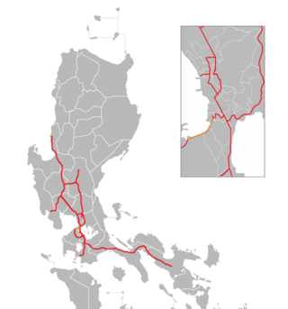
The Manila–Cavite Expressway, signed as E3 of the Philippine expressway network and R-1 of Metro Manila's arterial road network, is a 14-kilometer-long (8.7 mi) controlled-access toll expressway linking Manila to the southern province of Cavite in the Philippines. At its north end, it feeds into and from Roxas Boulevard in the city of Parañaque in Metro Manila, also part of R-1. At the south end, it splits into two termini, both along the north coast in Kawit, Cavite. The first feeds into the intersection of Tirona Highway and Antero Soriano Highway. The second southern terminus is on the intersection of Tirona Highway, Antero Soriano Highway and Covelandia Road in Kawit, Cavite.
The Diocese of Imus is a Roman Catholic diocese in the Philippines that comprises the entire province of Cavite. The diocese was canonically erected on November 25, 1961, when it was excised from the Archdiocese of Manila. Imus Cathedral, located along General Castañeda Street in the poblacion of Imus, serves as the see of the diocese. It is one of twelve cathedrals founded by the Order of Augustinian Recollects in the Philippines.
The Port of Manila refers to the collective facilities and terminals that process maritime trade function in harbors in Metro Manila. Located in the Port Area and Tondo districts of Manila, Philippines, facing Manila Bay, it is the largest and the premier international shipping gateway to the country. The Philippine Ports Authority, a government-owned corporation, manages the Port of Manila and most of the public ports in the country. It is composed of 3 major facilities, namely Manila North Harbor, Manila South Harbor, and the Manila International Container Terminal.
Naval Station Sangley Point was a communication and hospital facility of the United States Navy which occupied the northern portion of the Cavite City peninsula and is surrounded by Manila Bay, approximately eight miles southwest of Manila, the Philippines. The station was a part of the Cavite Navy Yard across the peninsula. The naval station had a runway that was built after World War II, which was used by U.S. Navy Lockheed P-2 Neptune, Lockheed P-3 Orion, and Martin P4M Mercator maritime patrol and anti-submarine warfare aircraft. An adjacent seaplane runway, ramp area and seaplane tender berths also supported Martin P5M Marlin maritime patrol aircraft until that type's retirement from active naval service in the late 1960s. NAS Sangley Point/NAVSTA Sangley Point was also used extensively during the Vietnam War, primarily for U.S. Navy patrol squadrons forward deployed from the United States on six-month rotations. The naval station was turned over to the Philippine government in 1971. It is now operated by the Philippine Air Force and Philippine Navy.
The Antero Soriano Highway, also partly known as Centennial Road, is a two-to-six lane, 21.6-kilometer (13.4 mi) highway traversing through the western coast of Cavite. It is one of the three major highways located in the province, the others are Aguinaldo Highway and Governor's Drive.
The Pacific Coast of Mexico or West Coast of Mexico stretches along the coasts of western Mexico at the Pacific Ocean and its Gulf of California.
Danilo Atienza Air Base is a military base used by the Philippine Air Force, located on the northern end of the Cavite Peninsula in Manila Bay, Luzon Island, Philippines. It is adjacent to Cavite City, in Cavite Province.
Naval Station Pascual Ledesma, also known as Cavite Naval Base or Cavite Navy Yard, is a military installation of the Philippine Navy in Cavite City. In the 1940s and '50s, it was called Philippine Navy Operating Base. The 9-hectare (22-acre) naval base is located at the easternmost end of Cavite Point in the San Roque district of the city. Via traffic lane, this naval establishment is next to the famous Samonte Park. It was the former extension of U.S. Naval Station Sangley Point which is now Naval Station Heracleo Alano. In 2009, it was named after Cmdre. Pascual Ledesma, a leader of the Philippine Revolution and the first Officer-In-Command of the Philippine Navy.
Circumferential Road 6 (C-6), informally known as the C-6 Road, is a network of roads and bridges that all together will form the sixth and outermost beltway of Metro Manila in the Philippines once it is completed.
Sangley Point Airport, also referred to as Cavite Airport, is a domestic airport at Sangley Point, Cavite City in the Philippines primarily serving general aviation and turbo-propped airliners in the general vicinity of South Luzon and the Greater Manila Area.
National Route 62 (N62) forms part of the Philippine highway network. It runs south from Metro Manila to northeastern Cavite.
Naval Base Manila, Naval Air Base Manila was a major United States Navy base south of the City of Manila, on Luzon Island in the Philippines. Some of the bases dates back to 1898, the end of the Spanish–American War. Starting in 1938 civilian contractors were used to build new facilities in Manila to prepare for World War II. Work stopped on December 23, 1941, when Manila was declared not defendable against the Empire of Japan southward advance, which took over the city on January 2, 1942, after the US declared it an open city. US Navy construction and repair started in March 1945 with the taking of Manila in the costly Battle of Manila ending on March 2, 1945. Naval Base Manila supported the Pacific War and remained a major US Naval Advance Base until its closure in 1971.
US Naval Base Philippines was number of United States Navy bases in the Philippines Islands in the Pacific Ocean. Most were built by the US Navy Seabees, Naval Construction Battalions, during World War II. The US Naval Bases in Philippines were lost to the Empire of Japan in December 1941 during the Philippines campaign of 1941–1942. In February 1945 the United States Armed Forces retook the Philippines in the Battle of Manila in 1945. Before the captured US bases on Luzon were retaken the US Navy Seabees built a new large base, Leyte-Samar Naval Base, on the Philippine Island of Leyte, starting in October 1944.
This page is based on this Wikipedia article Text is available under the CC BY-SA 4.0 license; additional terms may apply. Images, videos and audio are available under their respective licenses.