The Chattahoochee River forms the southern half of the Alabama and Georgia border, as well as a portion of the Florida - Georgia border. It is a tributary of the Apalachicola River, a relatively short river formed by the confluence of the Chattahoochee and Flint rivers and emptying from Florida into Apalachicola Bay in the Gulf of Mexico. The Chattahoochee River is about 430 miles (690 km) long. The Chattahoochee, Flint, and Apalachicola rivers together make up the Apalachicola–Chattahoochee–Flint River Basin. The Chattahoochee makes up the largest part of the ACF's drainage basin.

The Tennessee River is the largest tributary of the Ohio River. It is approximately 652 miles (1,049 km) long and is located in the southeastern United States in the Tennessee Valley. The river was once popularly known as the Cherokee River, among other names, as the Cherokee people had their homelands along its banks, especially in what are now East Tennessee and northern Alabama. In addition, its tributary the Little Tennessee River, flows into it from Western North Carolina and northeastern Georgia, where it also was bordered by numerous Cherokee towns. Its current name is derived from the Cherokee town, Tanasi, which was located on the Tennessee side of the Appalachian Mountains.

Lake Buchanan was formed by the construction of Buchanan Dam by the Lower Colorado River Authority to provide a water supply for the region and to provide hydroelectric power. Buchanan Dam, a structure over 2 mi (3.2 km) in length, was completed in 1939. Lake Buchanan was the first of the Texas Highland Lakes to be formed, and with 22,333 acres of surface water, it is also the largest. The surface of the lake includes area in both Burnet and Llano Counties. The lake is west of the city of Burnet, Texas.

The Coosa River is a tributary of the Alabama River in the U.S. states of Alabama and Georgia. The river is about 280 miles (450 km) long.
The D'Aguilar Range is a mountain range near Brisbane, Queensland, Australia. The town of Dayboro is situated on the lower foothills midway along the range and the Sunshine Coast Hinterland town of Mooloolah lies at the northernmost point of the range. Many residential areas line its eastern slopes including the town of Samford and the suburb of Ferny Hills. In the west, numerous ridges and gullies are heavily forested and designated as state forest or national park.

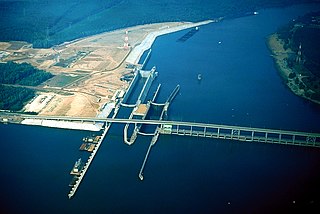
Guntersville Dam is a hydroelectric dam on the Tennessee River in Marshall County, in the U.S. state of Alabama. It is one of nine dams on the river owned and operated by the Tennessee Valley Authority, which built the dam in the late 1930s as part of a New Deal era initiative to create a continuous navigation channel on the entire length of the river and bring flood control and economic development to the region. The dam impounds the Guntersville Lake of 67,900 acres (27,500 ha), and its tailwaters feed into Wheeler Lake.

Stave Lake is a lake and reservoir for the production of hydroelectricity in the Stave River system, located on the northern edge of the District of Mission, about 65 km (40 mi) east of Vancouver, British Columbia, Canada. The main arm of the lake is about 20 km (12 mi) long from north to south and its southwest arm, ending at Stave Falls Dam near Stave Falls, is about 9.5 km (5.9 mi) long. The total area of the lake currently is about 55 square kilometres. Prior to construction of the dam, the lake was about one-third the size of its current main arm.

Cedar Bluff State Park is a public recreation area located 21 miles (34 km) southeast of WaKeeney and 23 miles (37 km) southwest of Ellis in Trego County, Kansas, United States.
Pickwick Lake is the reservoir created by Pickwick Landing Dam as part of the Tennessee Valley Authority. The lake stretches from Pickwick Landing Dam to Wilson Dam.

The Bear Creek Reservoir is a reservoir located in Franklin County, Alabama, along Bear Creek. Bear Creek Dam is one of four Tennessee Valley Authority dams in the area, 68 feet (21 m) high, creating a maximum flood control capacity of 37,800 acre-feet. No hydroelectric power is generated here.
Cedar Creek Reservoir may refer to various reservoirs in the United States:

Cedar Creek Reservoir is a reservoir located in Henderson and Kaufman Counties, Texas (USA), 50 miles (80.5 km) southeast of Dallas. It is built on Cedar Creek, which flows into the Trinity River. Floodwaters are discharged through a gated spillway into a discharge channel that connects to the Trinity River.
Big Creek Lake is a municipal reservoir which serves as the main source of drinking water for the city of Mobile, Alabama and its suburbs. It was formed by the damming of Big Creek, a tributary of the Escatawpa River in southwest Alabama. The reservoir was the subject of controversy in the 1980s over freshwater rights between Alabama and Mississippi.

The Cedar Pocket Dam is a partially concrete gravity and rock and earth-fill embankment dam with an un-gated spillway located across the Deep Creek in the Wide Bay–Burnett region of Queensland, Australia. The main purpose of the dam is for irrigation, where the dam provides regulated water supplies along Deep Creek, a tributary of the Mary River.

The William "Bill" Dannelly Reservoir is a reservoir created by Millers Ferry Lock and Dam on the Alabama River in Dallas County and Wilcox County in Alabama. It covers 27 square miles (70 km2) and has approximately 500 miles (800 km) of shoreline. It was named for William "Bill" Dannelly, a former Wilcox County probate judge credited with leading the modernization of the Alabama and Coosa Rivers.

Cedar Bluff Reservoir is a reservoir in Trego County, Kansas, United States. Built and managed by the U.S. Bureau of Reclamation for irrigation and area water supply, it is also used for flood control and recreation. Cedar Bluff State Park is located on its shore.