
The River Rhondda is a river in South Wales with two major tributaries, Rhondda Fawr and Rhondda Fach.
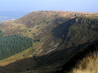
Craig y Llyn is a mountain situated to the south of the village of Rhigos in the Cynon Valley on the south side of the upper Vale of Neath and north of the Rhondda Valleys in South Wales; it is the highest point in the ancient kingdom and, later, county of Glamorgan (Morgannwg), and the southern Welsh coalfield plateau.

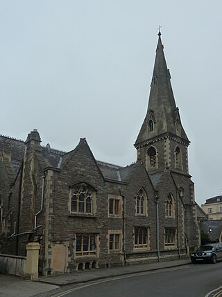
Llanwonno is a hamlet high up on the eastern side of Cefn Gwyngul, in the hills between the historic mining valleys of the Rhondda and the Cynon in Rhondda Cynon Taf, deep in the heart of the South Wales Valleys. Llanwonno today consists of St Gwynno's Church and an inn – The Brynffynon Hotel.

Mynydd Machen or Machen Mountain is a 362-metre-high (1,188 ft) hill lying between the town of Risca and the village of Machen in Caerphilly County Borough in south Wales. Its summit is crowned by a trig point and a mast.

Fan Llia is a subsidiary summit of Fan Fawr in the Fforest Fawr section of the Brecon Beacons National Park, Wales. In common with other peaks in the Fforest Fawr uplands it lies within the county of Powys.

Fan Gyhirych is a mountain in the Fforest Fawr section of Brecon Beacons National Park in south Wales. It lies within the county of Breconshire, and administered as part of the unitary authority of Powys.
Cadair Fawr is a hill in the northern corner of the county borough of Rhondda Cynon Taf, Wales. It lies within the Brecon Beacons National Park and Fforest Fawr Geopark. The 485m high summit at OS grid ref SN 978123 is marked by a trig point. Cadair Fawr is the highest point of a broad ridge known as Cefn Cadlan which forms the northern edge of Cwm Cadlan, a valley which itself runs east-northeastwards from the village of Penderyn. The name Cadair Fawr signifies the 'big chair' whilst Cefn Cadlan signifies the 'ridge of the battlefield'.

Mynydd Carn-y-cefn is the name given to the broad ridge of high ground between the Ebbw Vale and the valley of the Ebbw Fach in the Valleys region of South Wales. It lies within the county borough of Blaenau Gwent, formerly Monmouthshire.
The Pennant Measures is the traditional name for a sequence of sedimentary rocks of the South Wales Coalfield. They were also referred to as the Upper Coal Measures and assigned to the Westphalian 'C' and Westphalian 'D' stages of the Carboniferous Period. The Pennant Measures were divided into the Lower Pennant Measures and the Upper Pennant Measures, differing from the underlying Middle and Lower Coal Measures in being principally of sandstone units – known collectively as the Pennant Sandstone – with mudstone being the subsidiary rock type. Numerous coal seams occur within the Pennant Measures though they are less common than in the underlying Coal Measures.
Cefn Manmoel is the name given to the broad ridge of high ground between the Sirhowy Valley and Ebbw Vale in the Valleys region of South Wales. It straddles the boundary between the unitary areas of Caerphilly and Blaenau Gwent.

Mynydd Merthyr is a broad ridge of high ground between Taff Vale and the Cwm Cynon in the Valleys region of South Wales. It forms the boundary between the unitary authorities of Rhondda Cynon Taff to the west and Merthyr Tydfil to the east.

Mynydd Cilfach-yr-encil attains a height of 445m at OS grid reference SO 079033 making it the high point of the broad ridge of high ground between Taff Vale and Cwm Bargod in the Valleys region of South Wales. It lies within the County Borough of Merthyr Tydfil.
Mynydd Bedwellte is the name given to the broad ridge of high ground between the Rhymney Valley and the Sirhowy Valley in the Valleys region of South Wales. It straddles the boundary of the unitary areas of Caerphilly and Blaenau Gwent.
Cefn y Brithdir is the name given to the broad ridge of high ground between the Rhymney Valley and Cwm Darran in the Valleys region of South Wales. It lies within the County Borough of Caerphilly.
Cefn Eglwysilan is a hill in South Wales, the twin 382m summits of which lie 2 km east of Pontypridd in Rhondda Cynon Taf county borough. Its eastern side lies within the community of Aber Valley in Caerphilly county borough. Like neighbouring Mynydd Eglwysilan, the hill is named after the hamlet of Eglwysilan, the church here being dedicated to an obscure saint Ilan. A wireless transmission station is sited on the more northerly of the two summits. The southerly one is crowned by a trig point.
Mynydd Eglwysilan is a 355-metre-high hill in the Caerphilly county borough in South Wales 3 km to the south of Nelson and a similar distance southwest of Ystrad Mynach. To its south is Senghenydd at the head of the Aber Valley. Like neighbouring Cefn Eglwysilan, the hill is named after the hamlet of Eglwysilan 4 km to the southwest, the church here being dedicated to an obscure Saint Ilan. Remains of a linear earthwork known as Senghenydd Dyke stretch across the southern side of the hill. It is considered to mark the edge of an extensive 13th-century deer park associated with nearby Caerphilly Castle.
Mynydd y Gaer is a 295-metre-high hill in Bridgend County Borough in South Wales. The summit is crowned by a trig point.

Mynydd Twyn-glas is a sprawling 472-metre-high mountain extending into Caerphilly and Torfaen county boroughs in South Wales. It lies southwest of Pontypool, west of Cwmbran and east of Newbridge and taking the form of a rolling plateau the margins of which are defined by steep slopes, many of which are cloaked with conifer plantations. A broad shoulder extending south from the summit is known as Mynydd Maen whilst to the north is Mynydd Llwyd. The thickly afforested northern slopes of the hill drop down steeply into Cwm y Glyn.
Mynydd y Grug is a hill lying just west of the village of Cwmfelinfach and about 4 km to the northeast of Caerphilly in Caerphilly county borough in South Wales. Its summit was formerly at a height of around 358 m, but since the top has been covered by a large spoil heap and landscaped its height has now increased to 375 m, though some authorities take other values for the summit height. A number of ancient cairns are found along its edge overlooking the Sirhowy Valley, the slopes up from which are largely wooded.

Mynydd William Meyrick is a 535-metre-high hill straddling the boundary of Bridgend and Rhondda Cynon Taf county boroughs between the valley of the Rhondda Fawr and Ogmore Valley in South Wales. It takes the form of a broad northwest-southeast ridge with numerous broad shoulders extending to the east, south and west, each of which have different names and some of which constitute minor tops. Listed clockwise from the north these are; Mynydd Maendy, Mynydd Ton, Mynydd Bwllfa, Mynydd Pwllyrhebog, Mynydd Maes-teg, Mynydd y Gwair and Mynydd yr Aber. The summit of the entire massif is often referred to as Mynydd Ton. Its western sides are open moorland whilst its eastern sides have been afforested by the Forestry Commission.
