Central Park, Buffalo

Last updated

Central Park is a residential neighborhood in Buffalo, New York, United States. Its boundaries are Main Street to the west, Parkside Avenue to the east, Hertel Avenue to the north, and Amherst Street to the south, with its southwestern limit running along the railroad lining Linden Avenue. Amherst Street Station sits at Central Park's southeastern corner.

Contents

Central Park, Buffalo

The neighborhood originated from a development conceived by cement magnate Lewis Jackson Bennett (1833–1925) on his Buffalo Cement Company property. [1] [2] His Central Park home was designed by Buffalo architect Milton Earl Beebe. [2]

Early development

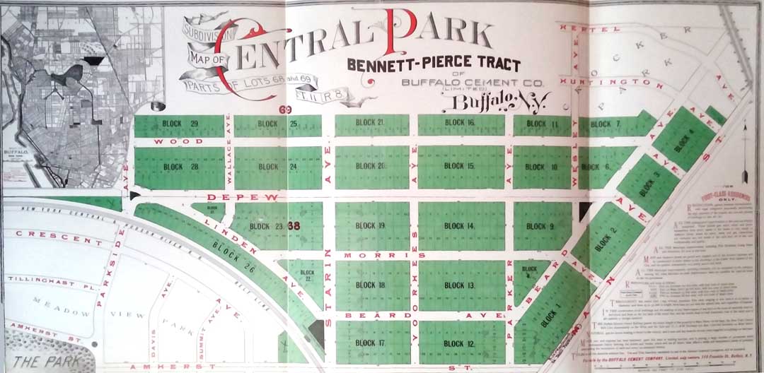
Bennett bought land in North Buffalo for a limestone source needed to establish a cement factory. Starting in 1875 he also acquired land on the east and west sides of Main Street where there were cement deposits. In 1877 he established the Buffalo Cement Company, operating a quarry and manufacturing stone and cement. Ten years later he planned a residential subdivision on the company's lands with his son, Leslie Jay Bennett, and William Pierce, a co-owner of Buffalo Cement. They decided to call the area Central Park because of its geographic location near Delaware Park. [1]

Later developments

Central Park was in close proximity to the Beltline Railroad and a station was built in Central Park (at Starin and Amherst). Known as the Central Park Station, it was owned by Buffalo Cement and leased by New York Central Railroad and Hudson River Railroad. [1]

The Otowega Club's clubhouse was located in the area at the corner of Linden and Starin. It was later used by the Art Institute of Buffalo before being demolished after World War II. Burke's Green initially was an unnamed parcel of park land deeded to the city by Bennett, with a beehive-style pile of rocks and a water pipe up that drizzled water over the rocks. Eventually this fountain was dismantled and an evergreen was placed in the center. Then, in the 1960s, the park was dedicated to the memory of F. Brendan Burke, and renamed Burke's Green. Bennett's house at 354 Depew Avenue was constructed in the area. It included 24 rooms and sat on 3 acres of land. It was demolished in 1935 and 12 building lots created. [1]

Bennett donated the land on Main Street to the City for Bennett High School and All-High Stadium. Bennett led a fight that helped bring about a change from the "rate bill system" to a free public school system paid for by taxes, considered to be the first district to adopt that system. He was a life member of the Buffalo Society of Natural Sciences and Buffalo Historical Society, a member of the National Society of the Sons of the American Revolution, and a member of the Buffalo Chamber of Commerce. He named streets after his family and friends, including Morris Avenue for the family of Lewis Bennett's brother-in-law, John Vedder Morris, and the man's father, Abram Vrooman Morris. John Morris married Mr. Bennett's younger sister Maria Lydia Bennett in 1875. Depew Avenue was named in honor of Chauncey M. Depew, a US Senator, New York State Secretary of State, and President of the New York Central Railroad. [1]

See also

Related Research Articles

<span class="mw-page-title-main">Erie County, New York</span> County in New York, United States

Erie County is a county along the shore of Lake Erie in western New York State. As of the 2020 census, the population was 954,236. The county seat is Buffalo, which makes up about 28% of the county's population. Both the county and Lake Erie were named for the regional Iroquoian language-speaking Erie tribe of Native Americans, who lived in the area before 1654. They were later pushed out by the more powerful Iroquoian nations tribes.

<span class="mw-page-title-main">Depew, New York</span> Village in New York, United States

Depew is a village in Erie County, New York. The population was 15,303 at the time of the 2010 census. It is part of the Buffalo–Niagara Falls metropolitan area. The village is named for Chauncey Depew, a politician and one of the original investors who bought the land for the village, which was incorporated in 1894.

<span class="mw-page-title-main">Pan-American Exposition</span> 1901 Worlds Fair held in Buffalo, New York, United States

The Pan-American Exposition was a World's Fair held in Buffalo, New York, United States, from May 1 through November 2, 1901. The fair occupied 350 acres (0.55 sq mi) of land on the western edge of what is now Delaware Park, extending from Delaware Avenue to Elmwood Avenue and northward to Great Arrow Avenue. It is remembered today primarily for being the location of the assassination of United States President William McKinley at the Temple of Music on September 6, 1901. The exposition was illuminated at night. Thomas A. Edison, Inc. filmed it during the day and a pan of it at night.

<span class="mw-page-title-main">Cheektowaga (town), New York</span> Town in New York, United States

Cheektowaga is a town in Erie County, New York, United States. As of the 2020 census, the town has grown to a population of 89,877. The town is in the north-central part of the county, and is an inner ring suburb of Buffalo. The town is the second-largest suburb of Buffalo, after the Town of Amherst.

<span class="mw-page-title-main">Lancaster (village), New York</span> Village in New York, United States

Lancaster is a village in Erie County, New York, United States. As of the 2010 census, the village population was 10,352. It is part of the Buffalo–Niagara Falls Metropolitan Statistical Area.

<span class="mw-page-title-main">Lancaster, New York</span> Town in New York, United States

Lancaster is a town in Erie County, New York, United States, centered 14 miles east of downtown Buffalo. Lancaster is an outer ring suburb of Buffalo. As of the 2020 Census, the town population was 45,106.

<span class="mw-page-title-main">Black Rock, Buffalo</span> Neighborhood in Buffalo, New York, United States

Black Rock, once an independent municipality, is now a neighborhood of the northwest section of the city of Buffalo, New York. In the 1820s, Black Rock was the rival of Buffalo for the terminus of the Erie Canal, but Buffalo, with its larger harbor capacity and greater distance from the shores of Canada, a recent antagonist during the War of 1812, won the competition. Black Rock took its name from a large outcropping of black limestone along the Niagara River, which was blasted away in the early 1820s to make way for the canal.

The Terminal Railway of Buffalo was a part of the New York Central Railroad system southeast of Buffalo, New York. It built the Gardenville Branch or Gardenville Cutoff, allowing through trains to bypass Buffalo. The cutoff has since been abandoned in favor of other parallel lines.

<span class="mw-page-title-main">Amherst Street station</span> Light rail station in Buffalo, New York, US

Amherst Street is a Buffalo Metro Rail underground station located at the corner of Main and Amherst Streets. From May 18, 1985 to November 10, 1986, due to construction issues at LaSalle station, Amherst Street station served as the northern terminus. The station has been referenced by rapper Westside Gunn numerous times.

The University Heights District is a neighborhood in Buffalo, New York.

<span class="mw-page-title-main">New York State Route 78</span> State highway in western New York, US

New York State Route 78 (NY 78) is a 73.49-mile-long (118.27 km) state highway in western New York in the United States. While it is signed north–south, the southern portion runs in an east–west direction across Wyoming and Erie counties, from its beginning at a junction with NY 19 north of the village of Gainesville to the village of East Aurora. The part of the route north of East Aurora follows a generally north–south alignment to an intersection with NY 18 in the Niagara County town of Newfane, just south of the Lake Ontario shoreline. The route is most closely identified in the region with Transit Road, a major north–south trunk road through the center of Erie and Niagara counties; however, NY 78 does not follow Transit Road for its entire length, nor does Transit Road comprise more than half its length. The highway joins Transit Road north of East Aurora and stays with the road until nearly its end in the city of Lockport.

<span class="mw-page-title-main">New York State Route 277</span> State highway in Erie County, New York, US

New York State Route 277 (NY 277) is a state highway in New York in the United States. This highway is also called Union Road, along with other names. NY 277 is a major north–south road east of Buffalo, New York, through the middle of Erie County. The section of NY 277 north of Orchard Park used to be New York State Route 18B until the portion of NY 18 south of Niagara Falls was deleted on January 1, 1962.

<span class="mw-page-title-main">New York State Route 130</span> State highway in Erie County, New York, US

New York State Route 130 (NY 130) is a state highway entirely within Erie County, New York, in the United States. It runs east–west from U.S. Route 62 in Buffalo to the village of Depew, where it terminates at US 20 and NY 78. Throughout this course, NY 130 is named Broadway, a roadway name that continues eastward beyond Depew even after NY 130 ends.

<span class="mw-page-title-main">Proposed expansion of the Buffalo Metro Rail</span> Grass-roots organization in Buffalo, New York

Since the Buffalo Metro Rail light rail was proposed in the 1970s, there have been multiple proposals for expanding the system, which is currently a single 6.4-mile (10.3 km) long line. Public officials, agencies and advocacy groups have created plans, with the most recent and formidable being an extension to the town of Amherst. One organization, the Citizens Regional Transportation Corporation (CRTC), promotes the implementation and expansions of light-rail service for the City of Buffalo and the surrounding Buffalo/Niagara region in New York State.

<span class="mw-page-title-main">Snyder, New York</span> Hamlet in New York, United States

Snyder is a hamlet within the town of Amherst in Erie County, New York, that is part of the Buffalo–Niagara Falls metropolitan area. The hamlet was established in 1837. It was named for Michael Snyder, its first postmaster, who also operated a store at the corner of Harlem Road, which is also known as New York State Route 240, and Main Street, which is also known as New York State Route 5. The hamlet blossomed due to retail activity demand created along the Main Street transportation route between Buffalo and points to the east in the 19th and early 20th century.

<span class="mw-page-title-main">North Buffalo, Buffalo, New York</span> Neighborhood in New York, United States

North Buffalo, is a neighborhood in the city of Buffalo, New York.

The Black Rock Rail Yard is on the west side of Buffalo, New York, a half mile inland from the Niagara River, in the Black Rock neighborhood. The rail yard receives Canadian National Railway freight trains arriving from Canada by way of the International Railway Bridge.

<span class="mw-page-title-main">North Park, Buffalo</span>

North Park is a neighborhood within the City of Buffalo in New York State. It is one of several neighborhoods that comprise the larger community of North Buffalo. The neighborhood's borders are roughly Delaware Avenue to the west, The former DL&W railroad to the north and east, and the Beltline Railroad and the Central Park neighborhood to the South.

<span class="mw-page-title-main">Transportation in Buffalo, New York</span>

Transportation in Buffalo, New York is dominated by automobile use, but other modes of transportation exist in the city.

References

  1. 1 2 3 4 5 http://buffalostreets.wordpress.com/2012/11/20/central-park/ Buffalo's Central Park: A Street, a Plaza and a Neighborhood November 20, 2012 by Angela Keppel
  2. 1 2 Lewis J. Bennett History of Buffalo reprint from Genealogical and Family History of Western New York, ed. by William Richard Cutter, 1912, Vol. II

Additional sources

Coordinates: 42°56′39″N78°50′31″W / 42.9441°N 78.8419°W / 42.9441; -78.8419