North Buffalo, Buffalo

Last updated
North Buffalo
Neighborhood
Former B'rith Israel Anshe Ames Synagogue, Buffalo, New York - 20200413.jpg
Mastman's is now Joe's.jpg
Northpark11.jpg
Former North Park Branch Library, Buffalo, New York - 20191025.jpg
HertelAvenue.JPG
Left to right from top: former B'rith Israel Anshe Ames Synagogue, Joe's Deli, North Park Theatre, Italian Cultural Center, Hertel Avenue business district
Nickname: 
Little Italy
CountryFlag of the United States.svg  United States
StateFlag of New York.svg  New York
CityFlag of Buffalo, New York.svg Buffalo, New York
Government
  Council MemberJoel Feroleto (D)

North Buffalo, is a neighborhood in the city of Buffalo, New York.

Contents

Geography

North Buffalo is one of Buffalo's 5 main areas (North Buffalo, South Buffalo, East Side, West Side, Central Business District) and contains several of Buffalo's 35 neighborhoods including

North Buffalo stretches from the city's border with Kenmore, New York to several neighborhoods to the south with Delaware Park forming the southern border. At its western boundary is Elmwood Avenue. The eastern border is Main Street. The topography of North Buffalo is flat. Cornelius Creek once flowed through North Buffalo, along a path roughly following Hertel Avenue. Cornelius Creek is now one of the many buried creeks in Buffalo, and is incorporated into the city's storm sewer system.

The area is serviced by the NFTA's Metro Rail LaSalle Station and Amherst Street Station as well as by the NFTA's buses on Delaware Avenue (No. 25), Colvin Avenue (No. 11), Hertel Avenue (No. 23), Elmwood Avenue (No. 20), Main Street (No. 8), Kenmore Avenue (No.5), and Amherst Street (No. 32).

Culture

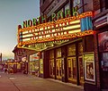
North Buffalo is heavily populated with Italian-Americans, as evidenced by the Hertel Avenue strip which has many Italian restaurants, bakeries, and stores. This area along Hertel Avenue is now locally known as Little Italy. Many Italians in North Buffalo migrated from the West Side in the 1970s and 1980s, when Puerto Ricans first began to settle in traditionally Italian-American neighborhoods west of Richmond Avenue. The Italian Village Festival, now called the Italian Heritage Festival, moved from Connecticut Street on the West Side to Hertel Avenue in North Buffalo in 1988.

From the 1950s until the late 1970s, North Buffalo was the historic center of Buffalo's Jewish community. Jews first settled in North Buffalo in the 1920s, with Jewish developers building a sizable number of single-family houses and two-flats in the North Park/Hertel Avenue area. The growth of the neighborhood's Jewish population rapidly accelerated in the 1950s, when urban renewal in the Lower East Side, and racial transition exacerbated by blockbusting in the Hamlin Park neighborhood, displaced the formerly large Jewish population of those communities. Although the majority of Jews in the Buffalo area now live in suburban Amherst and Williamsville, many remain in North Buffalo; particularly secular and Orthodox Jews. The neighborhood is home to several Orthodox synagogues and schools, [1] and institutions such as the Schvitz. [2]

Because of its pedestrian-oriented environment; proximity to downtown Buffalo, the University at Buffalo, and suburban office parks; and high-quality 1920s-era housing stock, North Buffalo is experiencing an influx of young professional homebuyers.

Notable events

For many years, North Buffalo held the annual Italian Heritage and Food Festival along Hertel Avenue. Traditionally held in July, it was held August 1–4 in 2013. It is considered to be among the five largest street festivals in the United States.

Notable places

See also

Related Research Articles

<span class="mw-page-title-main">Kenmore, New York</span> Village in New York, United States

Kenmore is a village in Erie County, New York, United States. The population was 15,205 at the 2020 census. It is part of the Buffalo-Niagara Falls metropolitan area.

<span class="mw-page-title-main">Tonawanda (town), New York</span> Town in New York, United States

Tonawanda is a town in Erie County, New York, United States. As of the 2020 census, the town had a population of 72,636. The town is at the north border of the county and is the northern inner ring suburb of Buffalo. It is sometimes referred to, along with its constituent village of Kenmore, as "Ken-Ton". The town was established in 1836, and up to 1903 it included what is now the city of Tonawanda.

<span class="mw-page-title-main">Niagara Frontier Transportation Authority</span> Public transit operator in Erie and Niagara Counties, New York

The Niagara Frontier Transportation Authority (NFTA) is the public agency responsible for operating most public transportation services in the Buffalo–Niagara Falls metropolitan area. The NFTA, as an authority, oversees a number of subsidiaries, including the NFTA Metro bus and rail system, the Buffalo-Niagara International Airport, the Niagara Falls International Airport and NFTA Small Boat Harbor. The NFTA Metro bus and rail system is a multi-modal agency, utilizing various vehicle modes, using the brand names: NFTA Metro Bus, NFTA Metro Rail, NFTA Metrolink and NFTA PAL. In 2022, the system had a ridership of 14,061,700 or about 53,200 per weekday as of the second quarter of 2023. In addition, the NFTA also owns and manages a number of properties, including the Buffalo Metropolitan Transportation Center in Downtown Buffalo ; the Niagara Falls Transportation Center on Factory Outlet Boulevard; the Portage Road Transit Center in Niagara Falls; and a number of strategically located bus loops and transit centers in the Buffalo Niagara region. Of note, many of the bus loops have been in continuous operation since the days of the International Railway Company, a predecessor to the NFTA. Agency-wide, the NFTA employs 1,500 full-time and part-time employees. There are three business centers that operate as the NFTA organization: Surface Transportation, which handles ground transportation throughout Erie and Niagara counties, Aviation, which handles air related business at the Buffalo-Niagara International Airport and Niagara Falls International Airport and Property Risk/Management, which operates the NFTA-Boat Harbor and handles other properties that are owned and/or operated by the NFTA.

<span class="mw-page-title-main">New York State Route 198</span> Highway in Buffalo, New York

New York State Route 198 (NY 198) is a state highway located entirely within the city of Buffalo, New York, in the United States. It is named the Scajaquada Expressway for Scajaquada Creek, which it covers as it heads across northern Buffalo. NY 198 connects the Niagara Thruway in the Black Rock neighborhood to the Kensington Expressway (NY 33) on Buffalo's east side, dividing the city's premier public park in half.

<span class="mw-page-title-main">Amherst Street station</span> Light rail station in Buffalo, New York, US

Amherst Street is a Buffalo Metro Rail underground station located at the corner of Main and Amherst Streets. From May 18, 1985 to November 10, 1986, due to construction issues at LaSalle station, Amherst Street station served as the northern terminus. The station has been referenced by rapper Westside Gunn numerous times.

<span class="mw-page-title-main">LaSalle station (Buffalo Metro Rail)</span> Light rail station in Buffalo, New York, US

LaSalle is a Buffalo Metro Rail underground station located at the corner of Main Street and LaSalle Avenue and is one stop from the northern terminus. Original drafting plans had the station used as a turnout between the current Metro Rail line and three proposed extensions; the Tonawanda Line, which would extend service into the cities of Tonawanda and Niagara Falls; the North Buffalo Line, which would extend service to Elmwood Avenue on an abandoned railroad right-of-way between Hertel and Kenmore Avenues; and the East Buffalo line, to connect the Main Street line with the proposed Airport Line, carrying passengers to the Buffalo-Niagara International Airport. The only visible sign of the turnout is located below ground by way of partially finished tunnel just west of the LaSalle station platforms. From May 20, 1985 to November 10, 1986, due to construction issues at LaSalle station, Amherst Street station served as the northern terminus. Since November 10, 1986, University station serves as the northern terminus.

<span class="mw-page-title-main">University station (Buffalo Metro Rail)</span> Light rail station in Buffalo, New York, US

University is a Buffalo Metro Rail station located near the intersection of Main Street and Niagara Falls Boulevard on the University at Buffalo South Campus. It is a major transfer point between Metro Rail and many city and suburban bus routes and offers a unique "Kiss and Ride" facility on the top level, above the mezzanine. This allows drivers of automobiles a separate area to drop off passengers, so they do not add to the traffic congestion from buses at the station during rush-hour periods and a large park-and-ride facility directly to the east of the station. Since University station serves as a terminal, immediately south is a double crossover. From May 20, 1985, to November 10, 1986, due to construction issues at LaSalle station, Amherst Street station served as the northern terminus. Since November 10, 1986, university station has served as the northern terminus.

The University Heights District is a neighborhood in Buffalo, New York.

<span class="mw-page-title-main">Delaware Park–Front Park System</span> United States historic place

Delaware Park–Front Park System is a historic park system and national historic district in the northern and western sections of Buffalo in Erie County, New York. The park system was designed by Frederick Law Olmsted and Calvert Vaux and developed between 1868 and 1876.

<span class="mw-page-title-main">New York State Route 384</span> State highway in western New York, US

New York State Route 384 (NY 384) is a state highway in Western New York in the United States. It is a north–south route extending from the city of Buffalo, Erie County to the city of Niagara Falls, Niagara County, and is one of several routes directly connecting the two cities. The southern terminus of the route is at NY 5 in downtown Buffalo. NY 384's northern terminus is at the Rainbow Bridge in downtown Niagara Falls. Through its entire course in Erie County, it is known as Delaware Avenue for the street it follows in the city. In Niagara County, NY 384 follows the Niagara River and is named River Road and Buffalo Avenue.

<span class="mw-page-title-main">Proposed expansion of the Buffalo Metro Rail</span> Grass-roots organization in Buffalo, New York

Since the Buffalo Metro Rail light rail was proposed in the 1970s, there have been multiple proposals for expanding the system, which is currently a single 6.4-mile (10.3 km) long line. Public officials, agencies and advocacy groups have created plans, with the most recent and extensive being an extension to the town of Amherst. Groups have formed on both sides of the issue.

<span class="mw-page-title-main">Allentown, Buffalo</span> United States historic place

The Allentown district is a neighborhood in Buffalo, New York. The neighborhood is home to the Allentown Historic District.

<span class="mw-page-title-main">International Railway (New York–Ontario)</span> Former urban transit company in Buffalo, NY

The International Railway Company (IRC) was a transportation company formed in a 1902 merger between several Buffalo-area interurban and street railways. The city railways that merged were the West Side Street Railway, the Crosstown Street Railway and the Buffalo Traction Company. The suburban railroads that merged included the Buffalo & Niagara Electric Street Railway, and its subsidiary the Buffalo, Lockport & Olcott Beach Railway; the Buffalo, Depew & Lancaster Railway; and the Niagara Falls Park & River Railway. Later the IRC acquired the Niagara Gorge Railroad (NGRR) as a subsidiary, which was sold in 1924 to the Niagara Falls Power Company. The NGRR also leased the Lewiston & Youngstown Frontier Railroad.

The Upper West Side is a neighborhood in Buffalo, New York.

<span class="mw-page-title-main">Elmwood Village, Buffalo</span> Neighborhood in New York, United States

Elmwood Village is a neighborhood in Buffalo, New York.

<span class="mw-page-title-main">North Park, Buffalo</span>

North Park is a neighborhood within the City of Buffalo in New York State. It is one of several neighborhoods that comprise the larger community of North Buffalo. The neighborhood's borders are roughly Delaware Avenue to the west, The former DL&W railroad to the north and east, and the Beltline Railroad and the Central Park neighborhood to the South.

Central Park is a residential neighborhood in Buffalo, New York, United States. Its boundaries are Main Street to the west, Parkside Avenue to the east, Hertel Avenue to the north, and Amherst Street to the south, with its southwestern limit running along the railroad lining Linden Avenue. Amherst Street Station sits at Central Park's southeastern corner.

<span class="mw-page-title-main">Transportation in Buffalo, New York</span>

Transportation in Buffalo, New York is dominated by automobile use, but other modes of transportation exist in the city.

References

42°56′12″N78°52′18″W / 42.9367°N 78.8718°W / 42.9367; -78.8718