
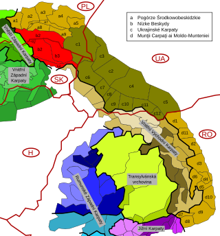
Divisions of the Carpathians are a categorization of the Carpathian mountains system.
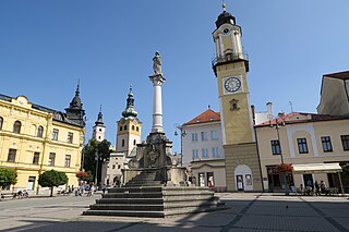
The Banská Bystrica Region is one of the eight regions of Slovakia. It is the largest of the eight regions by area, and has a lower population density than any other region. The Banská Bystrica Region was established in 1923; its borders were last adjusted in 1996. Banská Bystrica consists of 514 municipalities, 24 of which have town status. Its administrative center is the eponymous town of Banská Bystrica, which is also the region's largest town. Other important towns are Zvolen and Lučenec.

Malá Fatra is a mountain range in the Western Carpathians in the north-west of Central Slovakia. In the geomorphological system, it is a part of the Fatra-Tatra Area.
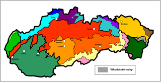
Vihorlat Mountains or colloquially Vihorlat is a volcanic mountain range in eastern Slovakia and western Ukraine. A part of the range is listed as a World Heritage Site.
Protected areas of Slovakia are areas that need protection because of their environmental, historical or cultural value to the nation. Protected areas in Slovakia are managed by institutions and organizations governed by the Ministry of the Environment.

Little Carpathians Protected Landscape Area is one of the 14 protected landscape areas in Slovakia. The Landscape Area is situated in the Little Carpathians, part of the Carpathian Mountains, in West Slovakia. The southwesternmost area is Devínska Kobyla in Bratislava, and the northeasternmost area is the Čachtice Carpathians at the town of Nové Mesto nad Váhom and the village of Čachtice in the Trenčín Region. Both areas are separated from the main mountain strip. The area protects 646.1 km2 (249.5 sq mi) of the mountains.

Dunajské luhy Protected Landscape Area is one of the youngest of the 14 protected landscape areas in Slovakia. The Landscape Area consists of five separate parts in the Danube Lowland, stretching from Bratislava in the north west, following the Danube and the borders between Slovakia and Hungary to a river island called Veľkolélsky ostrov in Komárno District. The biggest part is Žitný ostrov, the largest river island in Europe.

This article gives an overview of the geomorphological division of Slovakia. It is ordered in a hierarchical form, belonging to the Alps-Himalaya System and to the sub-systems of the Carpathian Mountains and of the Pannonian Basin. These subsystems are subsequently divided into provinces, sub-provinces and areas.

Strážov Mountains Protected Landscape Area is one of the 14 protected landscape areas in Slovakia. The Landscape Area is situated in the Strážov Mountains and the Súľov Mountains, part of the Western Carpathians, in western Slovakia. It is situated in the Bytča, Ilava, Považská Bystrica, Prievidza, Púchov, and Žilina districts.
Poľana Mountains Protected Landscape Area is one of the 14 protected landscape areas in Slovakia. The Landscape Area is situated in the Poľana Mountains, part of the Slovenské stredohorie Mountains, in Central Slovakia. It is situated in the Banská Bystrica, Brezno, Detva, and Zvolen districts.

Ponitrie Protected Landscape Area is one of the 14 protected landscape areas in Slovakia. The Landscape Area is situated in the Tribeč and Vtáčnik mountains, in western Slovakia. It is situated in the Nitra, Zlaté Moravce, Žarnovica, Topoľčany, Partizánske and Prievidza districts.

Kysuce Protected Landscape Area is one of the 14 protected landscape areas in Slovakia. It is made of two separate parts, the Javorníky mountains in the west, and Kysucké Beskydy mountains in the east, in north-western Slovakia. It is situated in the Čadca and Kysucké Nové Mesto districts, within the Kysuce region. It borders three other protected areas: the Beskydy Protected Landscape Area in the Czech Republic, Żywiec Landscape Park in Poland and Horná Orava Protected Landscape Area in Slovakia.

Horná Orava Protected Landscape Area is one of the 14 protected landscape areas in Slovakia. It is situated in the Námestovo and Tvrdošín districts, within the Orava region.
Štiavnické vrchy Protected Landscape Area is one of the 14 protected landscape areas in Slovakia. It is situated in the Banská Štiavnica, Zvolen, Žiar nad Hronom, Žarnovica, Levice and Krupina districts.
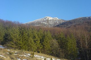
Strážov, at 1,213 m (3,980 ft), is the highest mountain in the Strážov Mountains, part of the Inner Western Carpathians, in Trenčín and Žilina Regions, Slovakia.
The Low Beskids or Central Beskids are a mountain range in southeastern Poland and northeastern Slovakia. They constitute a middle (central) section of the Beskids, within the Outer Eastern Carpathians.
The Novohrad – Nógrád Geopark (NNG), a geopark straddling the border between Hungary and Slovakia, is one of the first transnational geoparks in the world. It is a member of the UNESCO Global Geoparks Network and European Geoparks Network.

The Slovak-Moravian Carpathians are the mountain ranges along the border of the Czech Republic and Slovakia. Before the Treaty of Trianon in 1920, it was known in Hungarian as Magyar-morva határhegység 'the Hungarian-Moravian border mountains'.

Karancs is the highest peak in the Karancs Hills with an elevation of 729 metres (2,392 ft). It lies on the Hungarian-Slovak border. In Hungary, the mountain forms part of the Karancs-Medves Protected Landscape Area, while in Slovakia it is included in the Cerová vrchovina Protected Landscape Area.
Alúvium Blhu is a nature reserve in the Slovak county of Rimavská Sobota in the municipality of Hrušovo. It covers an area of 2,79 ha and has a protection level of 4 under the slovak law. It is part of the Cerová vrchovina Protected Landscape Area

