Copán is one of the departments in the western part of Honduras. The departmental capital is the town of Santa Rosa de Copán. The department is well known for its tobacco and fine cigars.

The flag of Honduras consists of three equal horizontal stripes of cyan, white and cyan, with five cyan stars in a quincuncial pattern at the centre of the middle stripe. The two outer bands represent the Pacific Ocean and the Caribbean Sea, and also represent the blue sky and brotherhood. The inner band represents the land between the ocean and the sea, the peace and prosperity of its people, and purity of thoughts. The five stars represent the five nations of the former Federal Republic of Central America and the hope that the nations may form a union again.

Lempira is one of the 18 departments in Honduras. located in the western part of the country, it is bordered by the departments of Ocotepeque and Copán to the west, Intibucá to the east, and Santa Bárbara to the north. To its south lies the El Salvador–Honduras border. The departmental capital is Gracias.
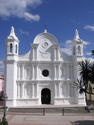
Santa Rosa de Copán is a municipality in Honduras. The city of Santa Rosa de Copán is the municipal seat and the departmental capital of the Honduran department of Copán. It is located approximately 1,150 metres (3,773 ft) above mean sea level.
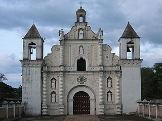
Gracias is a small Honduran town/municipality that was founded in 1536, and is the capital of Lempira Department.
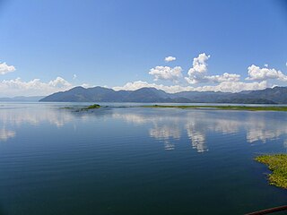
Lake Yojoa is the largest lake in Honduras with a surface area of 79 square kilometers and an average depth of 15 meters. At an altitude of 700 meters, it lies in a depression formed by volcanoes. The Lake Yojoa volcanic field consists of Pleistocene to Holocene scoria cones, craters, and lava flows.
San Agustín is a municipality in the Honduran department of Copán. It is situated 36.4 kilometres (22.6 mi) by road northwest of Santa Rosa de Copán.
Cerro Palenque is an archaeological site in the department of Cortés in Honduras. The city was founded in the Late Classic but reached its peak population and grew to over 500 structures in the Terminal Classic. Archaeologists cannot determine how the people who lived at Cerro Palenque would have identified themselves since unlike the Maya of Copan and far western Honduras, they left no writing. Over the years archaeologists have tried to ascertain the identity of the people who lived on the lower Ulua river drainage at various times in terms of populations known to have existed at the time of the Spanish conquest (1536). Popular candidates include the Tol, Lenca, and Maya. Unfortunately, archaeologists cannot currently determine if it was one of these groups, or some other unnamed group.

El Puente, or the Parque Arqueológico El Puente, is a Maya archaeological site in the department of Copán in Honduras. Once an independent Maya city, the city of El Puente became a tributary to the nearby city of Copán between the 6th and 9th centuries AD. The site contains more than 200 structures that include tombs, religious structures, and living quarters, but only a few have been excavated, including a large Maya step pyramid.

In Honduras, there is an important potential of untapped indigenous renewable energy resources. Due to the variability of high oil prices and declining renewable infrastructure costs, such resources could be developed at competitive prices.
Bolitoglossa oresbia is a species of salamander in the family Plethodontidae. It is endemic to Honduras and is known from the summit of Cerro El Zarciadero and the southwestern side of the nearby Cerro Azul Meámbar National Park, in the northern Comayagua Department.
Cortes salamander is a species of salamander in the family Plethodontidae. It is found in the Sierra de Omoa in northwestern Honduras and Sierra de Caral in eastern Guatemala, close to the border with Honduras. The vernacular name Cortes salamander refers to the Cortés Department where the type locality is located, whereas the alternative name Cortez' hidden salamander with the spelling "Cortez" and the apostrophe are errors.
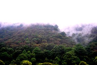
The Central American pine–oak forests is a tropical and subtropical coniferous forests ecoregion in the mountains of northern Central America and Chiapas state in southern Mexico.

The following is an alphabetical list of topics related to the Republic of Honduras.

Cerro Azul Meámbar National Park, also known as PANACAM, is a national park in Honduras. It was established on 1 January 1987 and covers an area of 300 square kilometres. It has an altitude of between 1,800 and 2,047 metres.
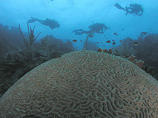
Honduras is a touristic destination that attracts visitors due to its natural environment, white and dark sand beaches, coral reefs, abundant flora and fauna, colonial era towns, and archaeological sites. Other attractions include the area's customs and traditional foods. In 2019 Honduras received 2.8 million foreigners, half of those tourists are cruise passengers.

Tourism accounts for a large part of El Salvador's economy. El Salvador has many natural attractions including beaches with some of the best surfing breaks on the Pacific Coast. El Salvador offers many lush forests shrouded in cool temperatures with abundant wildlife and scenic mountain-top vistas. El Salvador also has great potential in the field of cultural tourism; with over 2,000 known archaeological sites, mostly of the Maya and Olmec cultures. These sites are of international interest for their easy access and well-preserved remains.
Cerro Tenán is located near the village of Ojos de Agua, in the Municipality of Cucuyagua, in the Copán Department of Honduras. Tenán has an altitude of: 1,137 meters or 3,728 feet above sea level.

The Central American Atlantic moist forests ecoregion covers the lowland coastal forests of Honduras, southeast Guatemala, and the eastern forests of Nicaragua. Half of the ecoregion is closed-canopy tropical broadleaf evergreen forest, with tree heights reaching 50 meters. This ecoregion has the largest single fragment of natural forest in Central America, with a size of 14,629 square kilometres (5,648 sq mi). The total area is 89,979 square kilometres (34,741 sq mi).
