
Santa Cruz Province is a province of Argentina, located in the southern part of the country, in Patagonia. It borders Chubut Province to the north, and Chile to the west and south, with the Atlantic coast to the east. Santa Cruz is the second-largest province of the country, and the least densely populated in mainland Argentina.

Los Glaciares National Park is a federal protected area in Santa Cruz Province, Argentina.
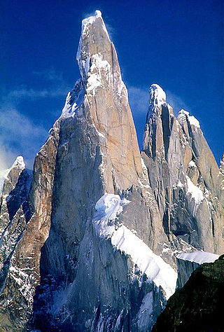
Cerro Torre is one of the mountains of the Southern Patagonian Ice Field in South America. It is located on the border dividing Argentina and Chile, west of Fitz Roy. At 3,128 m (10,262 ft), the peak is the highest of a four mountain chain: the other peaks are Torre Egger, Punta Herron, and Cerro Standhardt. The top of the mountain often has a mushroom of rime ice, formed by the constant strong winds, increasing the difficulty of reaching the actual summit.

Monte Fitz Roy is a mountain in Patagonia, on the border between Argentina and Chile. It is located in the Southern Patagonian Ice Field, near El Chaltén village and Viedma Lake. It was first climbed in 1952 by French alpinists Lionel Terray and Guido Magnone.
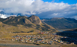
El Chaltén is a small mountain village in Santa Cruz Province, Argentina. It is located on the riverside of Rio de las Vueltas, within the Los Glaciares National Park near the base of Cerro Torre and Cerro Fitz Roy spires, both popular for climbing. It is 220 kilometres (140 mi) north of El Calafate. It is also a popular base for hiking numerous trails, such as those to the base of surrounding peaks and glacial lakes, such as Laguna Torre and Laguna de los Tres.

The Southern Patagonian Ice Field, located at the Southern Patagonic Andes between Chile and Argentina, is the world's second largest contiguous extrapolar ice field. It is the bigger of two remnant parts of the Patagonian Ice Sheet, which covered all of southern Chile during the last glacial period, locally called the Llanquihue glaciation.

Bernardo O'Higgins National Park is the largest of the protected areas in Chile, covering an area of 3,525,901 ha, in both the Aysén and Magallanes and Antártica Chilena regions. Management of this and other national parks in Chile is entrusted to the Corporación Nacional Forestal (CONAF). The park is named after General Bernardo O'Higgins, the first head of state of the Republic of Chile. Los Glaciares National Park (Argentina) and Torres del Paine National Park are its neighbours to the east, Laguna San Rafael National Park is located to the north, the Alacalufes National Reserve to the southwest, and the Katalalixar National Reserve to the northwest.

International relations between the Republic of Chile and the Argentine Republic have existed for decades. The border between the two countries is the world's third-longest international border, which is 5,300 km (3,300 mi) long and runs from north to south along the Andes mountains. Although both countries gained their independence during the South American wars of liberation, during much of the 19th and the 20th century, relations between the countries were tense as a result of disputes over the border in Patagonia. Despite this, Chile and Argentina have never been engaged in a war with each other. In recent years, relations have improved. Argentina and Chile have followed quite different economic policies. Chile has signed free trade agreements with countries such as China, the United States, Canada, South Korea, as well as European Union, and it's a member of the APEC. Argentina belongs to the Mercosur regional free trade area. In April 2018, both countries suspended their membership from the UNASUR.

The Aguja Saint Exupery is a mountain spear ('aguja') located near the Cerro Chaltén in the Los Glaciares National Park in Patagonia, Argentina.
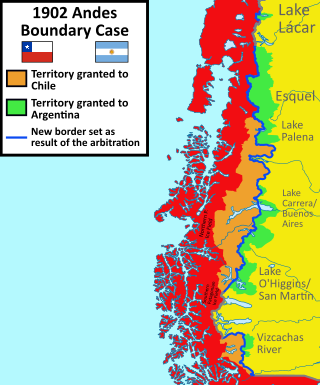
The 1902 Arbitral award of the Andes between Argentina and Chile was a British arbitration in 1902 that established the present-day boundaries between Argentina and Chile. In northern and central Patagonia, the borders were established between the latitudes of 40° and 52° S as an interpretation of the Boundary treaty of 1881 between Chile and Argentina.
Cerro Oasis or Agassiz Sur is a mountain in the mountain range of the Andes, located in the border between Argentina and Chile, in the region of Patagonia.

The Circo de los Altares is a geological formation of the Patagonian Andes, located in the Southern Patagonian Ice Field, where Mount Torre and Mount Fitz Roy can be seen from its western sides. It is located within the Area in dispute between Chile and Argentina with the border being defined in the northern area of the site.

The Southern Patagonian ice field dispute is a border dispute between Argentina and Chile over the delineation of the boundary line between the two countries on the Southern Patagonian Ice Field, a large expanse of glaciers located in the Patagonian Andes, which is the largest non-polar continental ice field with land access. It is called continental ice in Argentina and southern ice field in Chile, to differentiate it from the northern ice field. 2024, the Argentine–Chilean border in this sector is still pending of definition according to the 1998 agreement signed by both countries. The original border was defined 100 years prior on 1 October 1898 by experts from both countries.
Cerro Agassiz or formerly Cerro Bertrand is a mountain in the Andes, located on the border between Argentina and Chile, in the Patagonia region. It stands at an elevation of 3,177 meters.

Huemul Pass is a mountain pass located in the disputed area between Chile and Argentina in the Southern Patagonian Ice Field. The pass connects the Viedma Glacier with the Argentine town of El Chaltén.
The Cerro Huemul is a glaciated mountain in the Andes located on the eastern edge of the Southern Patagonian Ice Field, west of Lake Viedma and north of the Viedma Glacier within the disputed area between Chile and Argentina.
Cerro Heim is a mountain in the Southern Patagonian Ice Field. It is located in Santa Cruz Province, Argentina, and is part of Los Glaciares National Park. Prior to the 1998 agreement between Argentina and Chile, this hill was considered a border landmark by Chile and was established as a landmark by the surveyors of both countries in the 1898 protocol. It stands at an altitude of 2,465 m (8,087 ft).
The Cerro Cervantes is a mountain in the Southern Patagonian Ice Field with an elevation of 2,380 meters above sea level or 680 meters above the surrounding terrain. Its foothills are about 5.6 kilometers wide. It is located in Santa Cruz Province, Argentina, and is part of Los Glaciares National Park. Before the 1998 agreement between Argentina and Chile, this mountain was considered a border landmark by Chile.

Cerro Mayo or de Mayo is a mountain located in the Southern Patagonian Ice Field, in Santa Cruz Province, Argentina. It is part of Los Glaciares National Park.
Cerro Campana is a glaciated mountain in the Andes mountain range in Patagonia, located on the eastern edge of the Southern Patagonian Ice Field, west of Lake Viedma, and south of the glacier of the same name within the disputed area between Chile and Argentina.

