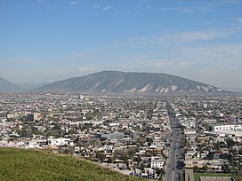
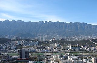
Monterrey is the capital and largest city of the northeastern state of Nuevo León, Mexico, and the ninth-largest city and second largest metro area in Mexico behind Greater Mexico City. Located at the foothills of the Sierra Madre Oriental, Monterrey is a major North American business and industrial hub, as well as the most populous city in Northern Mexico.
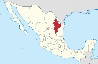
Nuevo León, officially the Free and Sovereign State of Nuevo León, is a state in northeastern Mexico. The state borders the Mexican states of Tamaulipas, Coahuila, Zacatecas, and San Luis Potosi, and has an extremely narrow international border with the U.S. state of Texas. Covering 64,156 square kilometers and with a population of 5.78 million people, Nuevo León is the thirteenth-largest federal entity by area and the seventh-most populous as of 2020.
Tlalnepantla is the name of a city and a municipality in the Mexican state of Morelos.
Totolapan is a municipality in the north of the Mexican state of Morelos, surrounded by the State of Mexico to the north; to the south with Tlayacapan and Atlatlahucan; to the east and southeast with Atlatlahucan; and to the west with Tlalnepantla.

San Pedro Garza García is a city-municipality in the Mexican state of Nuevo León and part of the Monterrey Metropolitan area. It is a contemporary commercial suburb of the larger metropolitan city of Monterrey between Puente de la Unidad and the Alfa Planetarium, including areas surrounding Calzada del Valle/Calzada San Pedro. In 2018 it was evaluated as having the best quality of life in Mexico. It has luxury shopping malls, large green areas, as well as important colleges and hospitals. Cerro de Chipinque and Chipinque Ecological Park are notable aspects of the city. The city hosts the head offices of companies like ALFA, Cemex, Gamesa, Vitro, Pyosa, Softtek and Cydsa.
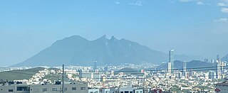
The Cerro de la Silla is a mountain and natural monument, It is part of the foothills system of the Sierra Madre Oriental. It is found covering territorial parts of the municipalities of Guadalupe (31.62%), Monterrey (13.23%) and Juárez (55.15%), in the state of Nuevo León, and constitutes an icon of the city of Monterrey and a symbol for the people of Monterrey.

San Nicolás de los Garza, sometimes known only as San Nicolás, is a city and coextensive municipality in the Mexican state of Nuevo León that is part of the Monterrey metropolitan area. It has become primarily a city for residences and family houses, although it still has several factories that tend to relocate to the periphery of the metropolitan area. It is the fifth-largest city in the state, behind Monterrey, Guadalupe, Ciudad Apodaca and General Escobedo.

Guadalupe is a city and surrounding municipality located in the state of Nuevo León, in northern Mexico. It is part of the Greater Monterrey Metropolitan area.

General Escobedo, or simply Escobedo, is a city and municipality in Nuevo León, Mexico that is part of the Monterrey Metropolitan area. As of the census of 2005, the population was 295,131 in the city and 299,364 in the municipality. The municipality has an area of around 149 km² and shares borders to the south with San Nicolás de los Garza, Monterrey and Santa Catarina; to the north with Hidalgo and El Carmen; to the east with Apodaca and Salinas Victoria; and to the west with García. Escobedo is also the home of the Mexican Army's 7th Military Zone Army Base.

The University of Monterrey is a private, Catholic, secondary, and higher education institution in city-municipality San Pedro Garza García, Greater Monterrey, Nuevo León, Mexico.
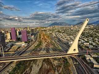
The Monterrey metropolitan area, also known as Greater Monterrey, refers to the surrounding urban agglomeration of Monterrey, Nuevo León. Officially called Area Metropolitana de la Ciudad de Monterrey, the metropolitan area is the 2nd-largest in Mexico.

The Cerro de las Mitras, is a mountain and a protected area in the Monterrey, San Pedro Garza García, Santa Catarina and García municipalities; state of Nuevo León, México. The mountain is part of the Sierra Madre Oriental, the summit reaches 2,058 MASL, and has 1,303 meters of prominence, the topographic isolation is about 14.48 km. The ridge is about 21 km long stretching east to west. The name comes from the resemblance of the peaks in the ridge with a bishop's mitre.
Cerro de la Loma Larga, or Loma Larga, is a lower extension of the Sierra Madre Oriental, particularly of Cerro de las Mitras. located in the Monterrey, Nuevo León metropolitan area.

Loma Larga Tunnel, or, as it is known by the locals, Túnel de la Loma Larga, is a road tunnel beneath the Cerro de la Loma Larga, in the limits of the cities of Monterrey and San Pedro Garza García in Nuevo León, México.

Alberto del Canto, formally Alberto Vieira do Canto, was a Portuguese noble, military captain, and conquistador who explored northern Mexico, where he was the founder of several cities.

The Cumbres de Monterrey is a national park of Mexico located in the northern portion of the Sierra Madre Oriental in the states of Nuevo León and Coahuila, near the city of Monterrey. The park protects more than 1,770 square kilometres (680 sq mi) of rugged terrain boasting deep canyons, rivers, waterfalls, and scenic mountain peaks, including the Cerro de la Silla, part of Monterrey's famous skyline.
El Carmen, often known as "Carmen", is a town and municipality of the northeastern Mexican state of Nuevo León. The population was 6,996 at the 2005 census. Located in the Salinas Valley region, it is one of the smallest municipalities of the state of Nuevo León, is bordered by the municipalities of Salinas Victoria at North and East, General Escobedo at South, Abasolo and Hidalgo at West. As of 2009, its population is projected to be much higher than it was in the last census, as there is a large number of people moving to this municipality and surrounded municipalities, mainly people from other places outside Nuevo León, because of the lower house prices, compared to that of Monterrey, and the increasing potential of the region due to the relatively close distance to Monterrey, and constant expansion of its metropolitan area, which is estimated to absorb this municipality soon.
Supermercados Internacionales HEB, S.A. de C.V. is the Mexican division of H-E-B, a private supermarket chain based in San Antonio, Texas, U.S. It competes mainly with Soriana, Walmart México, Bodega Aurrerá, S-Mart, Chedraui and Casa Ley.

Allende Municipality is a municipality located in the northeastern Mexican state of Nuevo León. It comprises a region known as Región Citrícola, for being a major producer of orange at local, national and even international level. Allende is located at the Sierra Madre Oriental range foothills in the central-southeastern part in the state of Nuevo León. It has a territorial extension of 148.5 km2, comprising around 0.22% of the whole extension of Nuevo León. Given its geographic location, the region consists of valleys and hills ranging from 300 meters above sea level on the northeast, to 1,640 meters above sea level in the southwestern part of the municipality. According to the 2010 census data, it had a population of 32,581, of whom 16,436 were men and 16,145 were women. The main economic activities are agriculture, livestock, beekeeping, poultry and transportation, activities that generate many jobs in the region.

The Sierra del Fraile, also known as "Cerro del Fraile", is a mountain and a protected area located in the García, Abasolo, Hidalgo, General Escobedo, El Carmen y Mina municipalities in the state of Nuevo León, México. The mountain is part of Sierra Madre Oriental; its summit elevation is 2,392 MASL, and its prominence is 1,592 meters. It is an ultraprominent peak, with a topographic isolation of about 23.5 km.