Bessarabia is a historical region in Eastern Europe, bounded by the Dniester river on the east and the Prut river on the west. About two thirds of Bessarabia lies within modern-day Moldova, with the Budjak region covering the southern coastal region and part of the Ukrainian Chernivtsi Oblast covering a small area in the north.

Budjak, also known as Budzhak, is a historical region that was part of Bessarabia from 1812 to 1940. Situated along the Black Sea, between the Danube and Dniester rivers, this multi-ethnic region covers an area of 13,188 km2 (5,092 sq mi) and is home to approximately 600,000 people. The majority of the region is now located in Ukraine's Odesa Oblast, while the remaining part is found in the southern districts of Moldova. The region is bordered to the north by the rest of Moldova, to the west and south by Romania, and to the east by the Black Sea and the rest of Ukraine.
The history of the Jews in Bessarabia, a historical region in Eastern Europe, dates back hundreds of years.
Sarata is a rural settlement in Bilhorod-Dnistrovskyi Raion, Odesa Oblast (region) of south-western Ukraine. It is a part of the Bessarabian historic district of Budjak. Sarata hosts the administration of Sarata settlement hromada, one of the hromadas of Ukraine. Population: 4,159.

Lăpușna County was a county in the Kingdom of Romania between 1925 and 1938 and between 1941 and 1944.
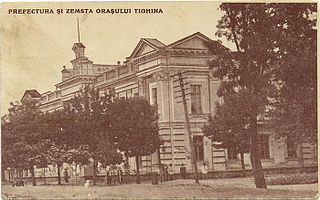
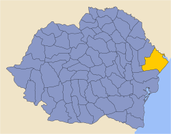
Tighina County was a county in the Kingdom of Romania between 1925 and 1938 and between 1941 and 1944.

Hotin County was a county in the Principality of Moldavia (1359–1812), the Governorate of Bessarabia (1812–1917), the Moldavian Democratic Republic (1917–1918), and the Kingdom of Romania.

Soroca County was a county in the Kingdom of Romania between 1925 and 1938 and between 1941 and 1944. The seat was Soroca.

Artsyz is a city in Bolhrad Raion of Odesa Oblast, Ukraine. It hosts the administration of Artsyz urban hromada, one of the hromadas of Ukraine. Population: 14,355. In 2001, population was 16,370. In 2001, the city of Artsyz was 66.51% Russian-speaking, 22.57% Ukrainian-speaking, 7.9% Bulgarian-speaking, and 1.49% Romanian-speaking. The city had 16,268 inhabitants in 2001, of which 6,495 identified themselves as ethnic Ukrainians (39.92%), 5,258 as ethnic Russians (32.32%), 3,075 as Bulgarians (18.90%), 695 as Moldovans (4.27%) and 204 (1.25%),as Gagauz.

The Tatarbunary Uprising was a Bolshevik-inspired and Soviet-backed peasant revolt that took place on 15–18 September 1924, in and around the town of Tatarbunary in Budjak (Bessarabia), then part of Romania, now part of Odesa Oblast, Ukraine. It was led by a pro-Soviet revolutionary committee which called for the creation of a "Moldavian Soviet Republic" and an end to "Romanian occupation".
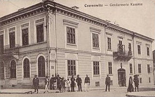
Cernăuți County was a county (județ) of Romania, in Bukovina, with the capital city at Cernăuți. The area was incorporated into the Soviet Union in 1940 and again in 1944, and has been part of Ukraine since 1991.

Storojineț County was a county (județ) of Romania, in Bukovina, with the capital city at Storojineț. The area was incorporated into the Soviet Union in 1940 and again in 1944, and has been part of Ukraine since 1991.
Armenians in Moldova are the ethnic Armenians that live in Moldova. They settled in the Principality of Moldavia since the Late Middle Ages, and were well known as a merchant community. They prospered, and built a number of Armenian churches. Since the 18th century, however, their numbers decreased due to assimilation and emigration to other countries. During Soviet occupation, the number of Armenians increased a little, both during the 1950s-1980s, and when new immigrants came from Armenia, Azerbaijan during First Nagorno-Karabakh War in late 1980s. But after the fall of the Soviet Union, it decreased again.

Bălți County was a county in the Kingdom of Romania between 1925 and 1938 and between 1941 and 1944, with the seat at Bălți.
Orhei was a county in the Kingdom of Romania between 1925 and 1938, and again between 1941 and 1944, with the seat at Orhei.
This article discusses the administrative divisions of the Kingdom of Romania between 1941 and 1944. As a result of the Soviet occupation of Bessarabia and Northern Bukovina, Second Vienna Award and the Treaty of Craiova, territories that had previously been part of Romania were lost to the Soviet Union, Hungary and Bulgaria respectively. By September 1940 the administrative system set up in 1938 based on 'ținuturi' (regions) was disbanded and the former counties (județe) were reintroduced.
Shevchenkove is a village in Izmail Raion of Odesa Oblast of Ukraine. It belongs to Kiliia urban hromada, one of the hromadas of Ukraine. It is located 63 km (39 mi) from the raion center and 28 km (17 mi) from the Dzinilor railway station. The territory has a flat topography. A large cluster of water bodies in the Danube and Northern Black Sea basins is concentrated within a radius of 30 km (19 mi). According to the 2001 census, 5,625 inhabitants lived in the village, the territory is 6.37 km2 (2.46 sq mi), with the agricultural land measuring 98.68 km2 (38.10 sq mi), and by both indicators it is the largest village in the district.

Ismail County was a county (județ) of Romania between 1925 and 1938 and between 1941 and 1944, in Bessarabia, with the capital city at Ismail. It was also a county of Moldavia between 1856 and 1859, and of the Principality of Romania between 1859 and 1878, in Southern Bessarabia.

Cahul County was a county of the Kingdom of Romania between 1925 and 1938 and between 1941 and 1944, in the historical region of Bessarabia, the successor of Cahul County.
Chilia County was a county (județ) of Romania part of the Bessarabia Governorate. Having lost Bessarabia in 1940 following an ultimatum by the Soviet Union (USSR), Romania recovered the region in 1941 following the Axis invasion of the USSR during World War II. Chilia County was the only Romanian county in Bessarabia that had not been created earlier in the administrative reform of 1930.