
Hudson Bay, sometimes called Hudson's Bay, is a large body of saltwater in northeastern Canada with a surface area of 1,230,000 km2 (470,000 sq mi). It is located north of Ontario, west of Quebec, northeast of Manitoba, and southeast of Nunavut, but politically entirely part of Nunavut. It is an inland marginal sea of the Arctic Ocean. The Hudson Strait provides a connection between the Labrador Sea and the Atlantic Ocean in the northeast, while the Foxe Channel connects the Hudson Bay with the Arctic Ocean in the north. It drains a very large area, about 3,861,400 km2 (1,490,900 sq mi), that includes parts of southeastern Nunavut, Alberta, Saskatchewan, Ontario, Quebec, all of Manitoba, and parts of the U.S. states of North Dakota, South Dakota, Minnesota, and Montana. Hudson Bay's southern arm is called James Bay.

The Arctic Archipelago, also known as the Canadian Arctic Archipelago, is an archipelago lying to the north of the Canadian continental mainland, excluding Greenland and Iceland.

Pioneer Island is part of the Severnaya Zemlya group in the Russian Arctic. It measures 1,527 km2 (590 sq mi) in area. The island was discovered by Georgy Ushakov and Nikolay Urvantsev during their 1930-32 expedition.

Somerset Island is a large, uninhabited island of the Arctic Archipelago, that is part of the Canadian territory of Nunavut. The island is separated from Cornwallis Island and Devon Island to the north by the Parry Channel, from Baffin Island to the east by Prince Regent Inlet, from the Boothia Peninsula to the south by Bellot Strait, and from Prince of Wales Island to the west by Peel Sound. It has an area of 24,786 km2 (9,570 sq mi), making it the 46th largest island in the world and Canada's twelfth largest island.

The Queen Elizabeth Islands are the northernmost cluster of islands in Canada's Arctic Archipelago, split between Nunavut and the Northwest Territories in Northern Canada. The Queen Elizabeth Islands contain approximately 14% of the global glacier and ice cap area. The southern islands are called the Parry Islands or Parry Archipelago.
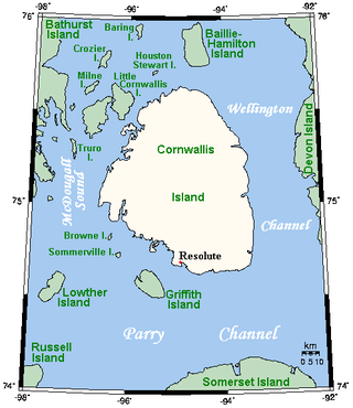
Cornwallis Island is one of the Queen Elizabeth Islands, part of the Arctic Archipelago, in the Qikiqtaaluk Region of Nunavut in the Canadian Arctic. It lies to the west of Devon Island, the largest uninhabited island in the world, and at its greatest length is about 113 km (70 mi). At 6,995 km2 (2,701 sq mi) in size, it is the 96th largest island in the world, and Canada's 21st largest island. Cornwallis Island is separated by the Wellington Channel from Devon Island, and by the Parry Channel from Somerset Island to the south. Northwest of Cornwallis Island lies Little Cornwallis Island, the biggest of a group of small islands at the north end of McDougall Sound, which separates Cornwallis Island from nearby Bathurst Island.

Ungava Bay is a bay in northeastern Canada separating Nunavik from Baffin Island. Although not geographically apparent, it is considered to be a marginal sea of the Arctic Ocean for climatic reasons. The bay is roughly oval-shaped, about 260 kilometres (160 mi) at its widest point and about 320 kilometres (200 mi) in length; it has an area of approximately 50,000 km2 (19,000 sq mi). It is generally fairly shallow, under 150 metres (490 ft), though at its border with the Atlantic Ocean depths of almost 300 metres (980 ft) are reached.
Siphonocladus is a small genus of green algae in the family Siphonocladaceae. The algal body (thallus) is composed of long, club-shaped cells that divide by segregative cell division, followed by the formation of branches that break through the mother cell.

The Nematophyta or nematophytes are a paraphyletic group of land organisms, probably including some plants as well as algae known only from the fossil record, from the Silurian period until the early Devonian Rhynie chert. The type genus Nematothallus, which typifies the group, was first described by Lang in 1937, who envisioned it being a thallose plant with tubular features and sporophytes, covered by a cuticle which preserved impressions of the underlying cells. He had found abundant disaggregated remains of all three features, none of which were connected to another, leaving his reconstruction of the phytodebris as parts of a single organism highly conjectural. No reproductive or vegetative structures common to the land plants are known, and certain members of the nematophyte plexus seem to belong to the fungi.
Chaetocladus is an extinct non-calcifying genus of unicellular green algae known from the Upper Silurian.
Griffith Island lies within the Arctic Archipelago in the Qikiqtaaluk Region of northern Canada's territory of Nunavut. It is one of the mid-channel islands in the western sector of Barrow Strait.
Truro Island lies within the Arctic Archipelago in the Qikiqtaaluk Region of northern Canada's territory of Nunavut. It is one of the mid-waterway islands in the McDougall Sound between Bathurst Island and Cornwallis Island. Long and narrow, the island is 21 km2 (8.1 sq mi).
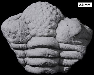
Frammia is a genus of trilobites in the order Phacopida that existed during the middle and upper Silurian in what is now the Arctic regions of Canada and Russia. It was described by Holtedahl in 1914, and the type species is Frammia dissimilis. That species was subsequently considered to be a synonym of Frammia arctica. The genus also contains the species, F. bachae Adrain & Edgecombe, 1997, F. hyperborea, and F. rossica. The type locality is the Douro Formation of Cornwallis Island in Nunavut, Canadian Arctic.
Macormick Bay is an Arctic waterway in Qikiqtaaluk Region, Nunavut, Canada. It lies off the southwestern coast of Devon Island in the eastern high Arctic. Like Baring Bay to the north, it is an arm of Wellington Channel.
Palaeocymopolia is an extinct genus of seaweed in the order Dasycladales, which existed in what is now Cornwallis Island, Nunavut, Northern Canada, during the Ludfordian age. It was described from the Cape Phillips Formation by Steven T. LoDuca, Michael J. Melchin and Heroen Verbruggen in 2011, and the type species is P. nunavutensis.
Eocladus xiaoi is an extinct species of seaweed which existed in what is now Cornwallis Island, Northern Canada, during the Ludfordian age. It was described by Steven T. LoDuca, Michael J. Melchin and Heroen Verbruggen in 2011 based on fossils found in the Cape Phillips Formation.
Palaeoaplysina is a genus of tabular, calcified fossils that are a component of many Late Palaeozoic reefs. The fossil acted as a baffle to trap sediment. Historically interpreted as a sponge or hydrozoan, recent studies are converging to its classification in the coralline stem group, placing it among the red algae.
The Bertie Group or Bertie Limestone, also referred to as the Bertie Dolomite and the Bertie Formation, is an upper Silurian geologic group and Lagerstätte in southern Ontario, Canada, and western New York State, United States. Details of the type locality and of stratigraphic nomenclature for this unit as used by the U.S. Geological Survey are available on-line at the National Geologic Map Database. The formation comprises dolomites, limestones and shales and reaches a thickness of 495 feet (151 m) in the subsurface, while in outcrop the group can be 60 feet (18 m) thick.
Tiiu Märss is an Estonian geologist and palaeoichthyologist.
Dudleyaspis is an extinct genus of Lower to Middle Devonian odontopleurid trilobites that lived in a shallow sea that lay between Euramerica and Gondwana. It was named in 1949 by Prantl & Pribyl.