Chalsa, India

Last updated

Chalsa
Census Town
West Bengal location map.svg
Red pog.svg
Chalsa
Location in West Bengal, India
India location map 3.png
Red pog.svg
Chalsa
Chalsa (India)
Coordinates: 26°53′N88°47′E / 26.88°N 88.78°E / 26.88; 88.78
CountryFlag of India.svg  India
State West Bengal
District Jalpaiguri
Elevation
163 m (535 ft)
Population
  Total4,973
Languages
  Official Bengali, English
Time zone UTC+5:30 (IST)
Vehicle registration WB

Chalsa (also known as Chalsa Mahabari) is a census town in the Matiali CD block in the Malbazar subdivision of the Jalpaiguri district in West Bengal, India.

Contents

Geography

Chalsa, India
Places and tea estates in Malbabazar subdivision (including Mal, Nagrakata and Matiali CD blocks) in Jalpaiguri district
CT: census town, R: rural/ urban centre, N: neighbourhood, NP: national park/ wildlife sanctuary, TE: tea estate
Abbreviations used in names – TG for Tea Garden (town/village), TE for Tea Estate, JRS: junction railway station
Owing to space constraints in the small map, the actual locations in a larger map may vary slightly

Location

Chalsa is located at 26°53′N88°47′E / 26.88°N 88.78°E / 26.88; 88.78 . [1] It has an average elevation of 163 metres (535 feet).

It situated at the foot of the Himalayas in the Duars. This small town is surrounded by hills, tea gardens, rivers and forests. One part of the town is surrounded by Gorumara National Park and other part with Chapramari Wildlife Sanctuary. Nearby forests are residence of a good collection of elephants and rhinos. It is situated on the way towards Birpara or Alipurduar from Siliguri via Malbazar. It takes around 1.5 hours from Siliguri both on road and railways. It is 60 km from Bagdogra airport.

According to the map of the Matiali CD block on page 165 in the District Census Handbook, Jalpaiguri, 2011 census, Chalsa Mahabari is shown as being the headquarters of the block and Matiali police station is shown as being located in Chalsa Mahabari. [2]

Area overview

Gorumara National Park has overtaken traditionally popular Jaldapara National Park in footfall and Malbazar has emerged as one of the most important towns in the Dooars. Malbazar subdivision is presented in the map alongside. It is a predominantly rural area with 88.62% of the population living in rural areas and 11.32% living in the urban areas. [3] [4] Tea gardens in the Dooars and Terai regions produce 226 million kg or over a quarter of India's total tea crop. [5] [6] Some tea gardens were identified in the 2011 census as census towns or villages. [7] Such places are marked in the map as CT (census town) or R (rural/ urban centre). Specific tea estate pages are marked TE.

Note: The map alongside presents some of the notable locations in the subdivision. All places marked in the map are linked in the larger full screen map.

Civic administration

Police station

Mitiali police station has jurisdiction over the Matiali CD block. [8] [9]

CD block HQ

The headquarters of the Matiali CD block are located at Chalsa Mahabari. [10]

Demographics

According to the 2011 Census of India, Chalsa Mahabari had a total population of 4,973 of which 2,461 (49%) were males and 2,512 (51%) were females. There were 489 persons in the age range of 0 to 6 years. The total number of literate people in Chalsa Mahabari was 3,471 (77.41% of the population over 6 years). [11]

Transport

Roadways

Siliguri is the best starting point. Siliguri is connected by air (Bagdogra) from New Delhi, Guwahati, Chennai and Kolkata and by rail (New Jalpaiguri) from Delhi, Guwahati, Kolkata. Siliguri is about 10 hours by road from Kolkata. From Siliguri, Chapramari Sanctuary and Gorumara National Park are an hour and half away. And Chalsa is surrounded by these two forests. Road and rail transport are available choices. The National Highway is in very good condition and driving is comfortable.

Railway

Chalsa Railway Station is on the New Jalpaiguri-Alipurduar-Samuktala Road Line serves the town of Chalsa and nearby areas.

Tourism

Various resorts and lodges around Gorumara. The Forest department has two bungalows each at Chapramari and Gorumara. There should be prior booking to avail these bungalows. There are also many cottages, resorts all around Garumara national park. They are mainly at Chalsa, Lataguri and Dhupjhora. Book your places to stay prior to arrival.

Related Research Articles

<span class="mw-page-title-main">Malbazar</span> Town in West Bengal, India

Malbazar, also known as Mal, is a town and a municipality in Jalpaiguri district in the state of West Bengal, India. It is the headquarters of the Malbazar subdivision. It lies about 65 km from Jalpaiguri and 55 km from Siliguri. It lies on the bank of river Neora.

<span class="mw-page-title-main">Mainaguri</span> Town in West Bengal, India

Mainaguri is a Town and a Municipality in the Jalpaiguri Sadar subdivision of the Jalpaiguri district in the state of West Bengal, India. It is known as the "Gateway of the Dooars" and is a regionally significant tourist destination for Jalpesh Temple of Lord Shiva and nearby Gorumara National Park.

Nagrakata is a village in the Nagrakata community development block in the Malbazar subdivision of the Jalpaiguri district, West Bengal.National Highway 17 passes through Nagrakata. It is a station on the New Jalpaiguri-Alipurduar-Samuktala Road Line.

Dam Dim is a village in the Mal CD blocks in the Malbazar subdivision of the Jalpaiguri district, West Bengal, India. It is famous for tea gardens and moist deciduous forests. Dam Dim is specially renowned for drama. Dam Dim has its own drama group, Damdim Yuba Natya Sangstha.

Matialihat is a census town in the Matiali CD block in the Malbazar subdivision of the Jalpaiguri district in the state of West Bengal, India.

Sulkapara is a village and a gram panchayat in the Nagrakata CD block in the Malbazar subdivision of the Jalpaiguri district in the state of West Bengal, India.

Bagrakote is a village in the Mal CD block in the Malbazar subdivision of the Jalpaiguri district in the state of West Bengal, India. The main reason behind Bagrakote being called as a Tea Garden is that it was by the virtue of the Duncan Goenka Group that established a tea garden in Bagrakote providing a stable livelihood. Thus people from neighbouring villages and even some far off places like Sikkim have migrated to Bagrakote, in search of better living conditions.Bargach is the capital of bagrakote.

<span class="mw-page-title-main">New Jalpaiguri–Alipurduar–Samuktala Road line</span> Railway line in West Bengal, India

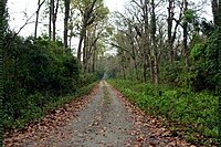
The New Jalpaiguri–Alipurduar–Samuktala Road line is a railway line that connects New Jalpaiguri- Siliguri Junction with Alipurduar and Samuktala Road in the Indian state of West Bengal. This railway line passes through the beautiful Doars region, which includes Mahananda Wildlife Sanctuary, Dooars-Terai tea gardens, Sevoke Railway Bridge, River Teesta, River Jaldhaka, River Torsha, Gorumara National Park, Buxa Tiger Reserve, Jaldapara National Park, Chapramari Wildlife Sanctuary, Chilapata Forests, Tunnels, Hills, Valleys etc.

<span class="mw-page-title-main">Murti, Jalpaiguri</span> Inhabited place in West Bengal, India

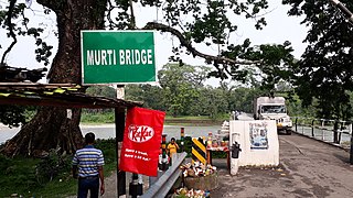
Murti is an inhabited place in the Matiali CD block in the Malbazar subdivision of the Jalpaiguri district in the state of West Bengal, India.

<span class="mw-page-title-main">Odlabari</span> Census Town in West Bengal, India

Odlabari is a census town in the Mal CD block in the Malbazar subdivision of the Jalpaiguri district in the state of West Bengal, India. It has become famous because it is the hometown of Biswadeb Das. He is famous for making and eating Rosogullas in Odlabari.

Dakshin Odlabari is a census town in the Mal CD block in the Malbazar subdivision of the Jalpaiguri district in the state of West Bengal, India.

Mangalbari is a census town in the Matiali CD block in the Malbazar subdivision of the Jalpaiguri district in the state of West Bengal, India.

Chalouni Tea Estate, Aibheel Tea Estate and Chalsa Tea Estate are tea gardens, located near each other in the Matiali CD block in the Malbazar subdivision of the Jalpaiguri district in the Indian state of West Bengal. All the three tea estates are located in the north-western section of the Dooars.

Zurantee Tea Garden is a village in the Matiali CD block in the Malbazar subdivision of the Jalpaiguri district in the state of West Bengal, India.

<span class="mw-page-title-main">Gurjangjhora Tea Garden</span> Village in West Bengal, India

Gurjangjhora Tea Garden is a village in the Mal CD block in the Malbazar subdivision of the Jalpaiguri district in the state of West Bengal, India.

Batabari Tea Garden is a village and a gram panchayat in the Matiali CD block in the Malbazar subdivision of the Jalpaiguri district in the state of West Bengal, India.

Gajoldoba or Gojaldoba is a village in the Rajganj CD block in the Rajganj subdivision of the Jalpaiguri district in the state of West Bengal, India.

Aryaman Tea Estate is a tea garden, located in the Madarihat-Birpara CD block in the Alipurduar subdivision of the Alipurduar district in the Indian state of West Bengal.

<span class="mw-page-title-main">New Jalpaiguri–Alipurduar Tourist Express</span> Express trains with Vistadome carriages

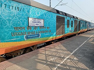
New Jalpaiguri–Alipurduar Tourist Express is the tourist Express trains in India that runs between New Jalpaiguri Junction and Alipurduar Junction in the Indian state of West Bengal. The train belongs to the Northeast Frontier Railway zone of Indian Railways. The service was officially started from 28 August 2021 from New Jalpaiguri. The train provides awesome sceneries of the beautiful Dooars region which includes Mahananda Wildlife Sanctuary, Sevoke Railway Bridge, River Teesta, River Jaldhaka, River Torsha, Dooars-Terai tea gardens, Buxa Tiger Reserve, Jaldapara National Park, Chapramari Wildlife Sanctuary, Rajabhatkhawa, etc. The passengers travelling by this train would also get to see the mesmerizing view of Sub-Himalayas, the glaciated rivers such as Teesta, Torsha, Daina river, Jaldhaka, Kuji Daina, Dima river, etc. The train will also cover many little villages, towns, etc. One of this train's stoppage is Hasimara Railway Station, which lies near the border of Bhutan. The passengers would also get to see views of Jayanti Hills, Sevoke, Chalsa, Terai–Duar savanna and grasslands and Malbazar. The passengers would also be entertained by dance performed by locals at some specific stations like Chalsa and Hasimara. There is also a selfie point in the Vistadome Coach. The train will cover three districts, which are Jalpaiguri District, Darjeeling District and Alipurduar District.

<span class="mw-page-title-main">Kranti (community development block)</span> Community development block in West Bengal, India

Kranti is a community development block that forms an administrative division in the Malbazar subdivision of the Jalpaiguri district in the Indian state of West Bengal.

References

  1. Falling Rain Genomics, Inc. - Rangpo
  2. "District Census Handbook Jalpaiguri, Series 20, Part XII A , 2011 census" (PDF). page 165: Map of Matiali CD block. Directorate of Census Operations West Bengal. Retrieved 26 June 2020.
  3. "Jalpaiguri". District Profile. District administration. Retrieved 13 July 2020.
  4. "District Statistical Handbook 2014 Jalpaiguri". Tables 2.2, 2.4b. Department of Planning and Statistics, Government of West Bengal. Archived from the original on 21 January 2019. Retrieved 13 July 2020.
  5. "Tea Growing Regions". Dooars and Terai. Indian Tea Association. Retrieved 13 July 2020.
  6. "Dooars-Terai". Tea Board India. Retrieved 13 July 2020.
  7. "2011 Census – Primary Census Abstract Data Tables". West Bengal – District-wise. Registrar General and Census Commissioner, India. Retrieved 13 July 2020.
  8. "District Statistical Handbook 2014 Jalpaiguri". Tables 2.1, 2.2. Department of Statistics and Programme Implementation, Government of West Bengal. Archived from the original on 21 January 2019. Retrieved 26 June 2020.
  9. "Search a Police Station". Jalpaiguri Police. Retrieved 26 June 2020.
  10. "District Census Handbook, Jalpaiguri, Series 20, Part XIIA" (PDF). Census of India 2011, Fifth page, map of Jalpaiguri district. Directorate of Census Operations, West Bengal. Retrieved 26 June 2020.
  11. "2011 Census – Primary Census Abstract Data Tables". West Bengal – District-wise. Registrar General and Census Commissioner, India. Retrieved 26 June 2020.