Chang'an Avenue

Last updated • 4 min readFrom Wikipedia, The Free Encyclopedia

Chang'an Avenue and Cultural Palace of Nationalities Chang'anAvenuepic1.jpg
Chang'an Avenue and Cultural Palace of Nationalities
Chang'an Avenue Chang'An Ave Jiannei.jpg
Chang'an Avenue
Morning traffic around Chang'an Avenue Chang'an avenue in Beijing.jpg
Morning traffic around Chang'an Avenue
Chang'an Avenue hosts military parades. Here are armoured fighting vehicles leaving Tian'anmen Square during the 1999 National Day parade. 50th anniversary of PRC 1.jpg
Chang'an Avenue hosts military parades. Here are armoured fighting vehicles leaving Tian'anmen Square during the 1999 National Day parade.

Chang'an Avenue (simplified Chinese :长安街; traditional Chinese :長安街; pinyin :Cháng'ān Jiē), literally "Eternal Peace Street", is a major thoroughfare in Beijing, China.

Contents

Chang'an (simplified Chinese :长安; traditional Chinese :長安; pinyin :Cháng'ān) is also the old name for Xi'an which was the capital of China during the Western Han dynasty, the Tang dynasty and other periods. The Avenue has also been referred to as the Shili Changjie (simplified Chinese :十里长街; traditional Chinese :十里長街; pinyin :Shílǐ Chǎngjiē), meaning the Ten Li Long Street, China's No. 1 Avenue and No. 1 Avenue of the Divine Land. [1] [2] "Chang'an Avenue" is often used as a synecdoche for the government in Beijing, akin to using "the Beltway" to refer to the American federal government. [3]

Chang'an Avenue starts from Dongdan in the east and ends at Xidan in the west. Tiananmen and Tiananmen Square are located at the north and south of the center of the Avenue, respectively. The Avenue consists of two parts, West Chang'an Avenue and East Chang'an Avenue. The extension line extends east–west with Tiananmen Square as the center, extends westward to Shougang area, Yongding River and Western Hills, and extends eastward to Beijing City Sub-center, Grand Canal and Chaobai River. [4] The core area of Chang'an Avenue and its extension is between Guomao Bridge of East Third Ring Road and Xinxing Bridge of West Third Ring Road (including Tiananmen area). [4]

History

The East and West Chang'an Streets were built as part of the Imperial City of Beijing. East Chang'an Street originally ran from the Left Chang'an Gate (on the east side of the square before Tian'anmen gate) to the Dongdan gate, and West Chang'an Street originally ran from the Right Chang'an Gate (on the west side of the same square) to the Xidan gate. The north side of the square, between the two Chang'an Gates, became a road after 1912 and was named "Zhongshan Road", after Sun Yat-sen. In 1940, the Inner City wall was breached at Jianguomen and Fuxingmen respectively, due east and west of the ends of the East and West Chang'an Street. Streets extending from the ends of the two Chang'an Streets were widened to become Jianguomen Inner and Outer Streets and Fuxingmen Inner and Outer Streets. The two Chang'an Streets thus became part of a major thoroughfare into and out of the Inner City, now considered the "extended" Chang'an Avenue. The two Chang'an Gates were demolished in 1952 to expand Tiananmen Square, after which the two Chang'an Streets and Zhongshan Road were merged, becoming a singular "Chang'an Avenue".

In 2009 the road was widened to 10 lanes, as part of the 60th anniversary of the founding of the People's Republic of China. [5]

Significance

Chang'an Avenue is the road directly before Tian'anmen gate and to the north of Tian'anmen Square. Because of its location, Chang'an Avenue has been associated with a number of important events in Chinese history, such as the Tian'anmen Square protests of 1989 (including the famous confrontation of the Tank Man), the May 4th Movement and the funeral procession of Zhou Enlai. During important celebrations in the People's Republic of China, military parades are conducted on Chang'an Avenue, with the procession travelling from East to West along the avenue, passing before Tiananmen gate. For this reason, the avenue is surfaced with reinforced concrete, to prevent tanks and other heavy vehicle from damaging the surface.

Located along Chang'an Avenue and near Tian'anmen Square are the Great Hall of the People, Zhongnanhai, and central government buildings. The National Museum of China, National Centre for the Performing Arts, Wangfujing, Beijing Concert Hall and the headquarters of the central bank of China, the People's Bank of China, and the Cultural Palace of Nationalities are also on Chang'an Avenue. Both the Beijing railway station and Beijing west railway station are located near Chang'an Avenue. Line 1 of the Beijing Subway runs under Chang'an Avenue. [6]

Because of its sensitive location, special regulations apply to Chang'an Avenue. For example, trucks and freight vehicles are banned day and night, [7] and no commercial advertising is allowed on the street. [8]

Sections

Note: This article considers Chang'an Avenue as the major through road from the W. 5th Ring Road through to the E. 5th Ring Road, which defines larger urban Beijing.

See also

Related Research Articles

<span class="mw-page-title-main">2nd Ring Road</span> Innermost circular highway around central Beijing, China

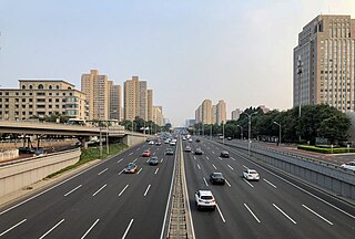
The 2nd Ring Road is the innermost ring road highway which encircles the city center of Beijing, People's Republic of China.

<span class="mw-page-title-main">Chaoyang, Beijing</span> District in Beijing, Peoples Republic of China

<span class="mw-page-title-main">Dongcheng, Beijing</span> District in Beijing, Peoples Republic of China

The Dongcheng District of Beijing covers the eastern half of Beijing's urban core, including all of the eastern half of the Old City inside of the 2nd Ring Road with the northernmost extent crossing into the area within the 3rd Ring Road. Its 40.6 km2 (15.7 sq mi) area is further subdivided into 17 subdistricts.

<span class="mw-page-title-main">Xicheng, Beijing</span> District in Beijing, Peoples Republic of China

Xicheng District is a district of Beijing. Its 32 square kilometers (12 sq mi) cover the western half of the old city, and has 706,691 inhabitants. Its postal code is 100032. Xicheng is subdivided into 15 subdistricts of the city proper of Beijing. The former Xuanwu District was merged into Xicheng in July 2010.

<span class="mw-page-title-main">Chaoyangmen</span> Location in Dongcheng District, Beijing

Chaoyangmen was a gate in the former city wall of Beijing. It is now a transportation node and a district border in Beijing. It is located in the Dongcheng District of northeastern central Beijing. Running from north to south is the eastern 2nd Ring Road. The Beijing Subway has a stop at Chaoyangmen.

<span class="mw-page-title-main">Jianguomen Outer Street</span> Road in Beijing, China

Jianguomen Outer Street, also transliterated as Jianguomen Wai Avenue is a major street in urban Beijing. It forms part of the extended Chang'an Avenue.

<span class="mw-page-title-main">Jianguomen Inner Street</span> Road in Beijing, China

Jianguomen Inner Street is a major street in urban Beijing. It forms part of the extended Chang'an Avenue.

<span class="mw-page-title-main">East Chang'an Avenue</span> Road in Beijing, China

East Chang'an Avenue is a major road in Beijing, China. It forms part of the extended Chang'an Avenue.

<span class="mw-page-title-main">West Chang'an Avenue</span> Road in Beijing, China

West Chang'an Avenue is a major avenue in urban Beijing. It forms part of the extended Chang'an Avenue.

<span class="mw-page-title-main">Fuxingmen Inner Street</span> Road in Beijing, China

Fuxingmen Inner Street is a major street in urban Beijing. It forms part of the extended Chang'an Avenue.

<span class="mw-page-title-main">Fuxingmen Outer Street</span> Road in Beijing, China

Fuxingmen Outer Street is a major street in urban Beijing. It forms part of the extended Chang'an Avenue.

<span class="mw-page-title-main">Line 1 (Beijing Subway)</span> Beijing Subway rail line

Line 1 of the Beijing Subway is the oldest and one of the busiest lines of Beijing's mass transit rail network. Line 1 runs underneath Chang'an Avenue, the city's grand east–west thoroughfare, right through the heart of Beijing with stops on either side of Tiananmen Square. Line 1's color is dark red. Through operation with the Batong line started on August 29, 2021.

<span class="mw-page-title-main">Line 2 (Beijing Subway)</span> Metro line in Beijing, China

Line 2 of the Beijing Subway is a rapid transit rail line in central Beijing that runs in a rectangular loop around the city centre. The line traces the Ming dynasty inner city wall, which was demolished and paved over by the 2nd Ring Road and Qianmen Avenue to make room. Line 2, opened in 1984, is the second oldest and one of the busiest of Beijing's subway lines, and to date only one to serve Beijing railway station. All 18 stations on the 23.1 km (14.4 mi) line are underground. 12 of the 18 stations offer transfers to other lines. Line 2's color is dark blue.

<span class="mw-page-title-main">Dongdan, Beijing</span>

Dongdan, literally "Eastern Single" or "Eastern Single Sign Gate" is the name of a crossing on Beijing's Chang'an Avenue and surrounding neighborhood. The name is derived from the single paifang or Chinese sign gate that once marked the intersection. In the checkerboard layout of Beijing, the Dongdan intersection in Dongcheng District to the east of the city centre, is balanced by Xidan or the "Western Single" in Xicheng District to the west of city centre. Dongdan and Xidan were traditionally market centers.

<span class="mw-page-title-main">Beijing city fortifications</span>

The Beijing city fortifications were series of walls with towers and gates constructed in the city of Beijing, China in the early 1400s until they were partially demolished in 1965 for the construction of the 2nd Ring Road and Line 2 of the Beijing Subway. The original walls were preserved in the southeastern part of the city, just south of the Beijing railway station. The entire perimeter of the Inner and Outer city walls stretched for approximately 60 kilometres (37 mi).

Chang'an was the capital of several Chinese dynasties, located on the site of present-day Xi'an, Shaanxi.

<span class="mw-page-title-main">Di'anmen</span>

Di'anmen previously Bei'anmen was an imperial gate in Beijing, China. The gate was first built in the Yongle period of the Ming dynasty, and served as the main northern gate to the Imperial City. The gate is located north of Jingshan Park and south of the Drum Tower. The gate was demolished in 1954. Efforts to restore it have been under way since 2013.

<span class="mw-page-title-main">West Chang'an Avenue Subdistrict</span> Subdistrict in Beijing, China

West Chang'an Avenue Subdistrict is a subdistrict on the eastern part of Xicheng District, Beijing.

Beijing has many neighborhoods, some of which are new and others with a long history.

References

  1. 王天淇 (7 November 2020). "长安街沿线环境景观新规施行 建筑应保持原有色调风格". 北京日报. Retrieved 1 December 2020.
  2. 张芽芽 (4 August 2008). ""神州第一街":长安街" (in Simplified Chinese). 新华网. Archived from the original on 25 August 2008. Retrieved 27 April 2009.
  3. 胡佳恒、郑东阳 (2009–1), 中国第一政治地标"大修" (in Simplified Chinese), 凤凰周刊{{citation}}: CS1 maint: numeric names: authors list (link)
  4. 1 2 北京市人民政府办公厅 (5 September 2020). 北京市长安街及其延长线市容环境景观管理规定  (in Chinese). 北京市 via Wikisource.{{citation}}: CS1 maint: location missing publisher (link)
  5. Beijing completes face-lift of main avenue for National Day. Xinhua. 25 August 2009.
  6. Welch, Patricia Bjaaland (2008). Chinese art: a guide to motifs and visual imagery. Tuttle Publishing. p. 270.
  7. The Current Major Traffic Management Measures of Urban Roads Archived 23 July 2011 at the Wayback Machine . Beijing Traffic Management Bureau. 15 May 2009.
  8. Beijing Bans Commercial Ads on Tian'anmen Square, Chang'an Avenue. Xinhua. March 27, 2006

39°54′27″N116°23′49″E / 39.90757°N 116.3970°E / 39.90757; 116.3970