G6 Beijing–Lhasa Expressway

Last updated • 2 min readFrom Wikipedia, The Free Encyclopedia
China Expwy G6 sign no name.svg
Beijing–Lhasa Expressway
北京-拉萨高速公路
Jingzang Expressway
京藏高速
G6 map.svg
The Beijing–Lhasa Expressway, including planned/under construction sections, is highlighted in red.
Badaling Expressway Juyongguan Great Wall.jpg
G6 and the Juyong Pass
Route information
Part of Tabliczka AH3.svg AH3 Tabliczka AH42.svg AH42
Length3,710 km [1]  (2,310 mi)
Length when complete.
Major junctions
East end 3rd Ring Road at Madian Bridge, Xicheng, BJ
Major intersections
West endXiongka IC at Doilungdêqên District, Lhasa, XZ
Location
Country China
Highway system
China Expwy G0513 sign no name.svg G0513 China Expwy G0601 sign no name.svg G0601

The Beijing–Lhasa Expressway (simplified Chinese :北京-拉萨高速公路; traditional Chinese :北京-拉薩高速公路; pinyin :Běijīng-Lāsà gāosù gōnglù), commonly abbreviated to Jingzang Expressway (Chinese :京藏高速), is part of the Chinese national expressway network and is planned to connect the nation's capital, Beijing, to the capital of the Tibet Autonomous Region, Lhasa.

Contents

It passes through seven of China's administrative regions, including the Beijing municipality, the province of Hebei, the autonomous regions of Inner Mongolia and Ningxia, the provinces of Gansu and Qinghai, and finally the Tibet Autonomous Region.

Passage

G6 Expressway at the interchange with the Fifth Ring Road in northern Beijing. G6 expressway from offramp to North Fifth Ring Road, Beijing.jpg
G6 Expressway at the interchange with the Fifth Ring Road in northern Beijing.

Beginning from Beijing and driving southwest to Lhasa, The expressway runs approximately 3,710 kilometres (2,310 miles) through Hebei, Inner Mongolia, Ningxia, Gansu and Qinghai, for a total of seven provincial-level divisions.[ clarification needed ] Excluding the two terminal points, it passes through the major cities of Zhangjiakou, Jining District, Hohhot, Bayannur, Wuhai, Yinchuan, Wuzhong, Baiyin, Lanzhou, Xining and Golmud.[ clarification needed ]

As of August 2010, just over fifty percent of the expressway is open to traffic, which mainly comprises the stretch between Beijing and Xining. Like China National Highway 109 and the Qingzang railway, it is expected to pass west through Golmud before heading southwest into Tibet and Lhasa. Because of climatic conditions, this stretch of the expressway does not yet have a construction timetable. [2]

As of 2019 the expressway is completed between Beijing and Golmud, and the section between Nagqu and Lhasa has completed in August 2021. The mountainous section between Golmud and Nagqu is not yet shown on maps, and reserved for future plans.

The G6 merges with the G7 in Huhhot and does not split until Linhe (now Baynnur).

Ningxia

The expressway is of particular importance in Ningxia, where 86.7% of the urban population lives in cities along the expressway, and over 90% of the provincial GDP is generated in these cities. In 2020, a 2x4 lane bypass around Ningxia's capital Yinchuan was opened, and another 212 kilometres (132 miles) in Ningxia will be widened to 2x3 lanes. [3]

Detailed itinerary

Pfeil unten.svg From Beijing Pfeil unten.svg
Continues as Deshengmen Outer Street
Kokudou 110(China).svg G110 Road
CH-Hinweissignal-Autobahn.svg
AB-Kreuz-blaugrun.svg
N 3rd Ring Road
Pfeil unten.svg Concurrent with Kokudou 110(China).svg G110 Road Pfeil unten.svg
1 A AB-AS-grun.svg Beitucheng W Rd
BJS Line 10 icon.svg Jiandemen station
1 B AB-AS-grun.svg Minzuyuan W Rd
Olympic Sports Centre
2 A-B AB-Kreuz-blaugrun.svg N 4th Ring Road
Asian Games Village
Zhongguancun
3 A AB-AS-grun.svg Zhixin Road
Anxiang Road
3 B AB-AS-grun.svg Qinghua Road
Datun Road
BJS Line 15 icon.svg Beishatan station
Tsinghua University
4 AB-AS-grun.svg Kehui Road
Toll Gate-CN.png Qinghe Toll Station
6 A-B AB-Kreuz-grun.svg Beijing Expwy S50 sign with name.svg N S50 5th Ring Road
8 AB-AS-grun.svg Shoudou 216(China).svg S216 Road
Xiaoying Road
10 AB-AS-grun.svg Shoudou 216(China).svg S216 Road
Anningzhuang Road
Jiancaicheng Road
Service Area Sign-CN.png Service Area
Pfeil oben.svg Beijing Metropolitan Area Pfeil oben.svg
12 A AB-AS-grun.svg Shoudou 216(China).svg S216 Road
Huangtudian Rd
Huilongguan
12 B AB-AS-grun.svg Shoudou 216(China).svg S216 Road
Huilongguan Rd
Huilongguan
BJS Line 13 icon.svg Longze station
16 AB-AS-grun.svg Shoudou 216(China).svg S216 Road
China County Road X023.svg X023 Road
Huilongguan
BJS Changping Line icon.svg Life Science Park station
20 AB-AS-grun.svg Shoudou 216(China).svg S216 Road
Shoudou 324(China).svg Shayang Highway
Shahe
22 AB-AS-grun.svg Shoudou 216(China).svg S216 Road
Baisha Road
Shahe
Towards Baishan-Xiaotangshan
25 A-B AB-Kreuz-grun.svg China Expwy G4501 sign with name.svg North G4501 6th Ring Road
Service Area Sign-CN.png Baige Service Area
28 AB-AS-grun.svg Shoudou 216(China).svg S216 Road
Baifuquan Road
Changping
Pfeil oben.svg Concurrent with Kokudou 110(China).svg G110 Road Pfeil oben.svg
32 A AB-AS-grun.svg Shoudou 216(China).svg S216 Road
Kokudou 110(China).svg G110 Road
Xiguan Road
Towards Shoudou 212(China).svg S212 Road
Changping
Ming tombs
BJS Changping Line icon.svg Ming Tombs station
32 B AB-Kreuz-grun.svg China Expwy G7 sign with name.svg G7 Jingxin Expressway
36 AB-AS-grun.svg Shoudou 216(China).svg S216 Road
Chenzhuang
40 AB-AS-grun.svg Shoudou 216(China).svg S216 Road
Shoudou 218(China).svg S218 Road
Towards Nankou-Wenquan
China Railways.svg   Line S2 S2线   Nankou station
46 AB-AS-grun.svg Shoudou 216(China).svg S216 Road
Great Wall-Juyong Pass
China Railways.svg   Line S2 S2线   Juyongguan station
53 AB-AS-grun.svg Shoudou 216(China).svg S216 Road
Great Wall-Shuiguan Section
China road sign Shi 36.gif Turn from "Departing Beijing" towards "Beijing"
58 AB-AS-grun.svg Badaling
Great Wall-Badaling
China Railways.svg   Line S2 S2线   Badaling station
62 AB-AS-grun.svg Shoudou 216(China).svg S216 Road
Shoudou 220(China).svg S220 Road
Towards Kangzhuang-Yanqing
65 AB-AS-grun.svg Shoudou 216(China).svg S216 Road
Shoudou 217(China).svg S217 Road
Kangzhuang
Toll Gate-CN.png Pfeil unten.svg Kangzhuang Toll Station Pfeil unten.svg
Service Area Sign-CN.png Kangzhuang Service Area
Pfeil oben.svg Beijing City Pfeil oben.svg
Pfeil unten.svg Hebei Province Pfeil unten.svg
Toll Gate-CN.png Pfeil oben.svg Donghuayuan Toll Station Pfeil oben.svg
76 AB-AS-grun.svg China County Road X415.svg X415 Road
Donghuayuan
96 AB-Kreuz-grun.svg China Expwy G7 sign with name.svg G7 Jingxin Expressway
Kokudou 110(China).svg G110 Road
Tumu-Huailai
106 AB-AS-grun.svg Shoudou 241(China).svg S241 Road
Towards Kokudou 110(China).svg G110 Road
Huailai
121 AB-AS-grun.svg Shoudou 346(China).svg S346 Road
Old G110 Road
Towards Kokudou 110(China).svg G110 Road
Xibali
128 AB-AS-grun.svg Kokudou 110(China).svg G110 Road
Xiahuayuan
CN road sign Jing 36.svg
AB-Kreuz-grun.svg
CN road sign Jing 36.svg China Expwy G95 sign with name.svg G95 Capital Ring Expressway
Pfeil unten.svg Concurrent with China Expwy G95 sign with name.svg G95 Capital Ring Expressway Pfeil unten.svg
AB-Kreuz-grun.svg Hebei Expwy S32 sign no name.svg S32 Xuanda Expressway
Kokudou 110(China).svg G110 Road
Gujiaying
Pfeil unten.svg Xuanhua Urban Area Pfeil unten.svg
154 AB-AS-grun.svg Kokudou 112(China).svg G112 Road
Towards Kokudou 110(China).svg G110 Road
Xuanhua-Centre
Pfeil oben.svg Xuanhua Urban Area Pfeil oben.svg
Pfeil oben.svg Concurrent with China Expwy G95 sign with name.svg G95 Capital Ring Expressway Pfeil oben.svg
161 AB-Kreuz-grun.svg China Expwy G95 sign with name.svg G95 Capital Ring Expressway (Zhangcheng Expressway)
AB-AS-grun.svg Kokudou 110(China).svg G110 Road
Zhangjiakou
AB-AS-grun.svg Binhe S Road
Zhangjiakou
172 AB-Kreuz-grun.svg Hebei Expwy S010 sign no name.svg S010 Zhangshi Expressway
(North of G6 Expressway to be renamed
China Expwy G1013 sign with name.svg G1013 Haizhang Expressway)
Service Area Sign-CN.png Zhangjiakou Service Area
188 AB-AS-grun.svg Kokudou 207(China).svg G207 Road
Towards Kokudou 110(China).svg G110 Road
Wanquan
Service Area Sign-CN.png Yujialiang Service Area
205 AB-AS-grun.svg China County Road X401.svg X401 Road
Towards Kokudou 110(China).svg G110 Road
Guoleizhuang
218 AB-AS-grun.svg Kokudou 110(China).svg G110 Road
Shoudou 247(China).svg S247 Road
Huai'an
Toll Gate-CN.png Huai'an Toll Station
Service Area Sign-CN.png Huai'an Service Area
CN road sign Jing 36.svg
AB-Kreuz-grun.svg
CN road sign Jing 36.svg Shanxi Expwy S45 sign with name.svg S45 Tianli Expressway
Pfeil oben.svg Hebei Province Pfeil oben.svg
Pfeil unten.svg Inner Mongolia Autonomous Region Pfeil unten.svg
273 AB-AS-grun.svg China County Road X565.svg X565 Road
Towards Kokudou 110(China).svg G110 Road
Xinghe
Toll Gate-CN.png Xinghe Toll Station
AB-AS-grun.svg Kokudou 110(China).svg G110 Road
Xinghe
AB-Kreuz-grun.svg Inner Mongolia Expwy S24 sign no name.svg S24 Xinba Expressway
AB-AS-grun.svg China County Road X201.svg X201 Road
Towards Kokudou 110(China).svg G110 Road
E'erdong
AB-AS-grun.svg Kokudou 110(China).svg G110 Road
Xiaonao'er
AB-Kreuz-grun.svg Inner Mongolia Expwy S54 sign no name.svg S54 Jining City Ring Expressway
Service Area Sign-CN.png Jining Service Area
Pfeil unten.svg Jining Urban Area Pfeil unten.svg
338 AB-AS-grun.svg Kokudou 208(China).svg G208 Road
Jining
Pfeil oben.svg Jining Urban Area Pfeil oben.svg
AB-Kreuz-grun.svg China Expwy G55 sign with name.svg G55 Erguang Expressway
360 AB-AS-grun.svg China County Road X552.svg X552 Road
Towards Kokudou 110(China).svg G110 Road
Meiligaitu
Service Area Sign-CN.png Zhuozishan Service Area
389 AB-AS-grun.svg Kokudou 110(China).svg G110 Road
Zhuozi
AB-AS-grun.svg Kokudou 110(China).svg G110 Road
Towards Qixiaying
Pfeil unten.svg Hohhot Metropolitan Area Pfeil unten.svg
Service Area Sign-CN.png Yulin Service Area
(1 A-B) AB-Kreuz-grun.svg China Expwy G7 sign with name.svg G7 Jingxin Expressway
China Expwy G0601HHHT sign with name.svg G0601 Hohhot Ring Expressway
Pfeil unten.svg Concurrent with China Expwy G7 sign with name.svg G7 Jingxin Expressway Pfeil unten.svg
Concurrent with China Expwy G0601HHHT sign with name.svg G0601 Hohhot Ring Expressway
AB-AS-grun.svg Shoudou 101(China).svg S101 Road
Towards Kokudou 110(China).svg G110 Road
Hohhot-Centre
480 AB-AS-grun.svg Shoudou 104(China).svg S104 Road
Hohhot-Centre
Towards Wuchuan
Pfeil oben.svg Hohhot Metropolitan Area Pfeil oben.svg
489 AB-AS-grun.svg Kokudou 110(China).svg G110 Road
Hohhot-West
Taigemu
Pfeil oben.svg Concurrent with China Expwy G0601HHHT sign with name.svg G0601 Hohhot Ring Expressway Pfeil oben.svg
(61) AB-Kreuz-grun.svg China Expwy G0601HHHT sign with name.svg G0601 Hohhot Ring Expressway
Service Area Sign-CN.png Service Area
509 AB-AS-grun.svg Kokudou 110(China).svg G110 Road
Bikeqi
521 AB-AS-grun.svg Kokudou 110(China).svg G110 Road
Chasuqi
Service Area Sign-CN.png Hasuhai Service Area
543 AB-AS-grun.svg Kokudou 110(China).svg G110 Road
Taosihao
AB-AS-grun.svg Kokudou 110(China).svg G110 Road
Meidaizhao
579 AB-AS-grun.svg Kokudou 110(China).svg G110 Road
Tumed Youqi
Pfeil unten.svg Baotou Metropolitan Area Pfeil unten.svg
AB-Kreuz-grun.svg China Expwy G65 sign with name.svg G65 Baomao Expressway
AB-AS-grun.svg Kokudou 110(China).svg G110 Road
China County Road X606.svg X606 Road
Baotou-Centre
629 AB-AS-grun.svg Kokudou 210(China).svg G210 Road
Baotou-Centre
645 AB-AS-grun.svg Kokudou 110(China).svg G110 Road
Baotou-Centre
655 AB-AS-grun.svg Kokudou 110(China).svg G110 Road
Baotou-Centre
663 AB-AS-grun.svg Kokudou 110(China).svg G110 Road
Baotou-West
Pfeil oben.svg Baotou Metropolitan Area Pfeil oben.svg
Service Area Sign-CN.png Baiyanhua Service Area
AB-AS-grun.svg Kokudou 110(China).svg G110 Road
Baiyanhua
AB-AS-grun.svg Kokudou 110(China).svg G110 Road
Gongmiaozi
Service Area Sign-CN.png Wulashan (Mt Urad) Service Area
AB-AS-grun.svg Kokudou 110(China).svg G110 Road
Urad Qianqi
Service Area Sign-CN.png Xixiaozhao Service Area
AB-AS-grun.svg China County Road X708.svg X708 Road
Xixiaozhao
807 AB-AS-grun.svg Shoudou 211(China).svg S211 Road
Wuyuan
AB-AS-grun.svg Kokudou 110(China).svg G110 Road
Bayannur
Pfeil oben.svg Concurrent with China Expwy G7 sign with name.svg G7 Jingxin Expressway Pfeil oben.svg
CN road sign Jing 36.svg
AB-Kreuz-grun.svg
CN road sign Jing 36.svg China Expwy G7 sign with name.svg G7 Jingxin Expressway
AB-AS-grun.svg Shuofang Rd
Bayannur
868 AB-AS-grun.svg Shoudou 312(China).svg S312 Road
Bayannur
Service Area Sign-CN.png Linhe-Xinqu (Bayannur) Service Area
AB-AS-grun.svg China County Road X713.svg X713 Road
Towards Kokudou 110(China).svg G110 Road
Chengguan
AB-AS-grun.svg Towards Kokudou 110(China).svg G110 Road
Toudaoqiao
Service Area Sign-CN.png Dengkou Service Area
937 AB-AS-grun.svg Gangtie N Rd
Towards Kokudou 110(China).svg G110 Road
Dengkou
AB-Kreuz-grun.svg Inner Mongolia Expwy S24 sign no name.svg S24 Xinba Expressway
Towards Kokudou 110(China).svg G110 Road
Balagong-Dengkou
951 AB-AS-grun.svg Kokudou 110(China).svg G110 Road
Balagong
Pfeil unten.svg Wuhai Urban Area Pfeil unten.svg
1004 AB-AS-grun.svg Kokudou 110(China).svg G110 Road
Wuhai-North
AB-AS-grun.svg Linyin Ave
Wuhai-Centre
1027 AB-AS-grun.svg Shoudou 215(China).svg S215 Road
Wuhai-South
Pfeil oben.svg Wuhai Urban Area Pfeil oben.svg
AB-AS-grun.svg Shoudou 215(China).svg S215 Road
Hainan
AB-Kreuz-grun.svg S33 Wuyin Expressway
(To be renamed China Expwy G1817 sign with name.svg G1817 Wuyin Expressway)
Pfeil oben.svg Inner Mongolia Autonomous Region Pfeil oben.svg
Pfeil unten.svg Ningxia Hui Autonomous Region Pfeil unten.svg
Toll Gate-CN.png Huinong Toll Station
Service Area Sign-CN.png Service Area
1079 AB-AS-grun.svg Kokudou 110(China).svg G110 Road
Huinong
Service Area Sign-CN.png Huinong Service Area
1093 AB-AS-grun.svg Towards Kokudou 109(China).svg G109 Road
Towards Kokudou 110(China).svg G110 Road
Hongguozi-Xiayingzi
1123 AB-AS-grun.svg Shoudou 301(China).svg S301 Road
Shizuishan-Pingluo
Service Area Sign-CN.png Shahu Service Area
1142 AB-AS-grun.svg China County Road X207.svg X207 Road
Yaofu-Xidatan
1159 AB-AS-grun.svg China County Road X207.svg X207 Road
Towards Kokudou 109(China).svg G109 Road
Sishilidian
1167 AB-Kreuz-grun.svg China Expwy G0601YC sign with name.svg G0601 Yinchuan Ring Expressway
Kokudou 109(China).svg G109 Road
Helan
Service Area Sign-CN.png Helan Service Area
Pfeil unten.svg Yinchuan Metropolitan Area Pfeil unten.svg
1177 AB-AS-grun.svg Helanshan Road
Yinchuan-Centre
1186 AB-Kreuz-grun.svg China Expwy G20 sign with name.svg G20 Qingyin Expressway
Shoudou 102(China).svg S102 Road
Yinchuan-East
1189 AB-Kreuz-grun.svg China Expwy G0601YC sign with name.svg G0601 Yinchuan Ring Expressway
Pfeil oben.svg Yinchuan Metropolitan Area Pfeil oben.svg
1202 AB-AS-grun.svg Kokudou 109(China).svg G109 Road
Yongning
Service Area Sign-CN.png Yongning Service Area
1224 AB-AS-grun.svg Kokudou 109(China).svg G109 Road
Shoudou 101(China).svg S101 Road
Yesheng
1234 AB-AS-grun.svg Hanba E Road
Qingtongxia
1238 AB-AS-grun.svg Shoudou 101(China).svg S101 Road
Wuzhong
AB-AS-grun.svg Ningxia Expwy S12 sign no name.svg S12 Guqing Expressway
1253 AB-AS-grun.svg Shoudou 101(China).svg S101 Road
Gaozha
Service Area Sign-CN.png Guanmahu Service Area
1280 AB-Kreuz-grun.svg Ningxia Expwy S19 sign no name.svg S19 Gunhong Expressway
Service Area Sign-CN.png Mingsha Service Area
1303 AB-AS-grun.svg Shoudou 101(China).svg S101 Road
Mingsha
1317 AB-Kreuz-grun.svg China Expwy G2012 sign with name.svg G2012 Dingwu Expressway
Pfeil unten.svg Concurrent with China Expwy G2012 sign with name.svg G2012 Dingwu Expressway Pfeil unten.svg
1323 AB-AS-grun.svg Kokudou 109(China).svg G109 Road
Shoudou 101(China).svg S101 Road
Zhongning
Pfeil oben.svg Concurrent with China Expwy G2012 sign with name.svg G2012 Dingwu Expressway Pfeil oben.svg
1334 AB-Kreuz-grun.svg China Expwy G2012 sign with name.svg G2012 Dingwu Expressway
1339 AB-AS-grun.svg Kokudou 109(China).svg G109 Road
Shoudou 101(China).svg S101 Road
Changshantou
Service Area Sign-CN.png Xiaohongguo Service Area
AB-Kreuz-grun.svg China Expwy G70 sign with name.svg G70 Fuyin Expressway
AB-AS-grun.svg Kokudou 109(China).svg G109 Road
Datanchuan
Service Area Sign-CN.png Xingren Service Area
1414 AB-AS-grun.svg Shoudou 202(China).svg S202 Road
Xingren
Toll Gate-CN.png Xingren Toll Station
Pfeil oben.svg Ningxia Hui Autonomous Region Pfeil oben.svg
Pfeil unten.svg Gansu Province Pfeil unten.svg
Toll Gate-CN.png Liuzhaike Toll Station
1425 AB-AS-grun.svg Kokudou 109(China).svg G109 Road
Wuhe
1455 AB-AS-grun.svg Kokudou 109(China).svg G109 Road
Wangjiashan
AB-AS-grun.svg Pingchuan
Service Area Sign-CN.png Xindun Service Area
AB-AS-grun.svg Kokudou 109(China).svg G109 Road
Pinchuan-Shuiquan
1504 AB-AS-grun.svg Kokudou 109(China).svg G109 Road
Shoudou 207(China).svg S207 Road
Liuchuan
Service Area Sign-CN.png Baiyin-East Service Area
1533 AB-AS-grun.svg Kokudou 109(China).svg G109 Road
Baiyin-East
AB-AS-grun.svg Kokudou 109(China).svg G109 Road
Baiyin-West
1572 AB-AS-grun.svg Kokudou 109(China).svg G109 Road
Gaolan
1582 AB-AS-grun.svg Lanqin High-speed way
Shuifu
AB-Kreuz-grun.svg China Expwy G30 sign with name.svg G30 Lianhuo Expressway
Concurrent with China Expwy G30 sign with name.svg G30 Lianhuo Expressway
AB-Kreuz-grun.svg China Expwy G30 sign with name.svg G30 Lianhuo Expressway
Gansu Expwy S13 sign no name.svg S13 Zhongchuan Airport Liaison Line
(Formerly named Gansu Expwy S1 sign no name.svg S1 Lanying Expressway)
(To be renamed China Expwy G1816 sign with name.svg G1816 Wuma Expressway)
1623 AB-AS-grun.svg Shoudou 201(China).svg S201 Road
Lanzhou-West
Lanzhou Botanical Garden
Pfeil unten.svg Lanzhou Metropolitan Area Pfeil unten.svg
1635 AB-AS-grun.svg Kokudou 109(China).svg G109 Road
Kokudou 312(China).svg G312 Road
Hekou
Pfeil oben.svg Lanzhou Metropolitan Area Pfeil oben.svg
Service Area Sign-CN.png Zhangjiasi Service Area
1666 AB-AS-grun.svg Kokudou 109(China).svg G109 Road
Huazhuang
AB-AS-grun.svg Kokudou 109(China).svg G109 Road
Haishiwan
Toll Gate-CN.png Haishiwan Toll Station
Pfeil oben.svg Gansu Province Pfeil oben.svg
Pfeil unten.svg Qinghai Province Pfeil unten.svg
Toll Gate-CN.png Machangyuan Toll Station
Service Area Sign-CN.png Machangyuan Service Area
AB-AS-grun.svg Kokudou 109(China).svg G109 Road
Machangyuan
1709 AB-AS-grun.svg Minhe
1750 AB-AS-grun.svg Kokudou 109(China).svg G109 Road
Ledu
Service Area Sign-CN.png Ledu Service Area
1779 AB-AS-grun.svg Kokudou 109(China).svg G109 Road
Shoudou 202(China).svg S202 Road
Ping'an
AB-Kreuz-grun.svg Qinghai Expwy S11 sign no name.svg S11 Zhanghe Expressway
(To be renamed China Expwy G0611 sign with name.svg G0611 Zhangwen Expressway)
Pfeil unten.svg Concurrent with Qinghai Expwy S11 sign no name.svg S11 Zhanghe Expressway Pfeil unten.svg
(To be renamed China Expwy G0611 sign with name.svg G0611 Zhangwen Expressway)
1784 AB-AS-grun.svg BSicon FLUGg.svg Xining Caojiabao Airport
CN road sign Jing 36.svg
AB-Kreuz-grun.svg
CN road sign Jing 36.svg Qinghai Expwy SXX sign no name.svg
Pfeil unten.svg Xining Metropolitan Area Pfeil unten.svg
1779 AB-AS-grun.svg Kokudou 109(China).svg G109 Road
Xining-East
1803 AB-Kreuz-grun.svg Qinghai Expwy S1112 sign no name.svg S1112 Ninghu Expressway
1814 AB-Kreuz-grun.svg Qinghai Expwy S1113 sign no name.svg S1113 Ninggui Expressesy
Shoudou 103(China).svg S103 Road
Xining-Centre
Pfeil oben.svg Concurrent with Qinghai Expwy S11 sign no name.svg S11 Zhanghe Expressway Pfeil oben.svg
(To be renamed China Expwy G0611 sign with name.svg G0611 Zhangwen Expressway)
1817 AB-Kreuz-grun.svg Qinghai Expwy S11 sign no name.svg S11 Zhanghe Expressway
(Formerly named as Qinghai Expwy S1 sign no name.svg S1 Ningda Expressway)
(To be renamed China Expwy G0611 sign with name.svg G0611 Zhangwen Expressway)
1819 AB-AS-grun.svg Haihu Ave
Xining-North
1827 AB-AS-grun.svg Shoudou 103(China).svg S103 Road
Dabuzi
AB-AS-grun.svg Shoudou 103(China).svg S103 Road
Xining-West
Pfeil oben.svg Xining Metropolitan Area Pfeil oben.svg
AB-AS-grun.svg Shoudou 103(China).svg S103 Road
Dabuzi
AB-AS-grun.svg Shoudou 103(China).svg S103 Road
Duba
Toll Gate-CN.png Doba Toll Station
CN road sign Jing 1-1.svg Kokudou 109(China).svg G109 Road
Kokudou 315(China).svg G315 Road
Towards Qinghai Expwy S2011 sign no name.svg S20 Huangxi Expressway
Huangyuan
CN road sign Jing 36.svg Under Construction CN road sign Jing 36.svg
1911 AB-AS-grun.svg Kokudou 109(China).svg G109 Road
Kokudou 214(China).svg G214 Road
Daotanghe
Toll Gate-CN.png Daotanghe Toll Station
AB-AS-grun.svg Kokudou 214(China).svg G214 Road
Gonghe
AB-AS-grun.svg N Huanghua Avenue
Gonghe
AB-Kreuz-grun.svg Qinghai Expwy SXX sign no name.svg Gongyu Expressway
(To be named China Expwy G0613 sign with name.svg G0613 Xili Expressway)
AB-AS-grun.svg China County Road X301.svg X301 Road
Towards Gonghe-Nandi
AB-AS-grun.svg China County Road X301.svg X301 Road
Towards Nandi
AB-AS-grun.svg Kokudou 109(China).svg G109 Road
Dashuiqiao
AB-AS-grun.svg Kokudou 109(China).svg G109 Road
Chaka
Toll Gate-CN.png Chaka Toll Station
Service Area Sign-CN.png Chaka Service Area
AB-Kreuz-grun.svg Qinghai Expwy S2013 sign no name.svg S2013 Chade Expressway
(To be renamed China Expwy G0612 sign with name.svg G0612 Xihe Expressway)
CN road sign Jing 1-1.svg Kokudou 109(China).svg G109 Road
Chaka
Pfeil unten.svg CN road sign Jing 36.svg Under Construction CN road sign Jing 36.svg Pfeil unten.svg
AB-Kreuz-grun.svg CN road sign Jing 36.svg China Expwy G3011 sign with name.svg G3011 Liyge Expressway
Pfeil oben.svg Qinghai Province Pfeil oben.svg
Pfeil unten.svg Tibet Autonomous Region Pfeil unten.svg
Pfeil oben.svg Towards Beijing Pfeil oben.svg

See also

Related Research Articles

<span class="mw-page-title-main">Qinghai–Tibet railway</span> Railway line in China

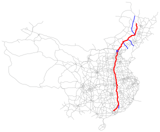
The Qinghai–Tibet railway or Qingzang railway, is a high-elevation railway line in China between Xining, Qinghai Province, and Lhasa, Tibet. With over 960 km (600 mi) of track being more than 4,000 m (13,123 ft) above sea level, it is the highest railway line in the world.

<span class="mw-page-title-main">G1 Beijing–Harbin Expressway</span> Expressway in Beijing, Tianjin, Hebei, Liaoning, Jilin and Heilongjiang provinces of China

The Beijing–Harbin Expressway, designated as G1 and commonly abbreviated as Jingha Expressway (京哈高速) is an expressway linking the cities of Beijing and Harbin, Heilongjiang.

<span class="mw-page-title-main">China National Highway 109</span> Road in China

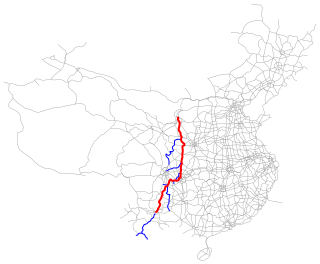
China National Highway 109 connects Beijing with Lhasa. It runs westwards from Beijing via Datong, Yinchuan and Xining to Golmud before turning southwest to Lhasa. The portion of the highway from Xining to Lhasa is known as the Qinghai-Tibet Highway. The total length of the route is 3,901 km.

<span class="mw-page-title-main">Ulanqab</span> City in Inner Mongolia, China

Ulanqab or Ulan Chab is a region administered as a prefecture-level city in south-central Inner Mongolia, China. Its administrative centre is in Jining District, which was formerly a county-level city. It was established as a prefecture-level city on 1 December 2003, formed from the former Ulanqab League. The Ulanqab Stadium is located in the city.

<span class="mw-page-title-main">Golmud</span> City in Qinghai Province, China

Golmud, also known by various other romanizations, is a county-level city in the Haixi Mongol and Tibetan Autonomous Prefecture of Qinghai Province, China. It is now the second-largest city in Qinghai and the third largest in the Tibetan Plateau. The population in 2020 is 221,863.

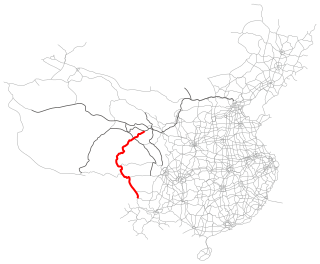
The Lanzhou–Qinghai railway, abbreviated as the Lanqing railway was built as the first step of an ambitious plan set by the People's Republic of China to connect Tibet with the rest of China by railway. LanQing railway, designed in 1956 and built from May 1958 to September 1959, runs 188 Kilometers long, connecting Lanzhou, the capital city of Gansu province, and Xining, the capital city of Qinghai province.

<span class="mw-page-title-main">Lanyin Mandarin</span> Branch of Mandarin Chinese in northwest China

Lan–Yin Mandarin (Lanyin) is a branch of Mandarin Chinese traditionally spoken throughout Gansu province and in the northern part of Ningxia. In recent decades it has expanded into northern Xinjiang. It forms part of Northwestern Mandarin. It has also been grouped together with Central Plains Mandarin. The name is a compound of the capitals of the two former provinces where it dominates, Lanzhou and Yinchuan, which are also two of its principal subdialects.

<span class="mw-page-title-main">G20 Qingdao–Yinchuan Expressway</span> Road in China

The Qingdao–Yinchuan Expressway, designated as G20 and commonly referred to as the Qingyin Expressway is an expressway that connects the cities of Qingdao, Shandong, China, and Yinchuan, Ningxia. It is 1,600 km (990 mi) in length.

<span class="mw-page-title-main">G85 Yinchuan–Kunming Expressway</span> Expressway in China

The Yinchuan–Kunming Expressway, designated as G85 and commonly referred to as the Yinkun Expressway is an expressway in China that connects the cities of Yinchuan, Ningxia and Kunming, Yunnan. It is 2,332 km (1,449 mi) in length. The full length was completed and opened for traffic in 2024.

<span class="mw-page-title-main">G45 Daqing–Guangzhou Expressway</span> Road in China

The Daqing–Guangzhou Expressway (大庆-广州高速公路), designated as G45 and commonly referred to as the Daguang Expressway (大广高速公路) is an expressway that connects the cities of Daqing, Heilongjiang, and Guangzhou, Guangdong in China. When fully complete, it will be 3,550 km (2,210 mi) in length.

<span class="mw-page-title-main">G70 Fuzhou–Yinchuan Expressway</span> Road in China

The Fuzhou–Yinchuan Expressway, designated as G70 and commonly referred to as the Fuyin Expressway is an expressway that connects the cities of Fuzhou, Fujian, China, and Yinchuan, Ningxia. It is 2,397.55 km (1,489.77 mi) in length.

<span class="mw-page-title-main">G3011 Liuyuan–Golmud Expressway</span> Road in China

The G3011 Liuyuan–Golmud Expressway, commonly referred to as the Liuge Expressway, is a planned expressway in China that will connect Liuyuan, a town in Guazhou County, Jiuquan, Gansu, and Golmud, Haixi Mongol and Tibetan Autonomous Prefecture, Qinghai.

<span class="mw-page-title-main">History of the administrative divisions of China (1949–present)</span>

The history of the administrative divisions of China after 1949 refers to the administrative divisions under the People's Republic of China. In 1949, the communist forces initially held scattered fragments of China at the start of the Chinese Civil War. By late 1949, they controlled the majority of mainland China, forcing the Republic of China government to relocate to Taiwan.

The Yinchuan Ring Expressway, designated as G2004, is an expressway in Ningxia, Northern China orbiting the city of Yinchuan. This expressway is a branch of G6 Beijing–Lhasa Expressway.

China Railway Qingzang Group, officially abbreviated as CR Qingzang or CR-Qingzang, also known as CR Qinghai-Tibet and CRQT, formerly, Qinghai-Tibet Railway Company or Qingzang Railway Company, is a subsidiary under the jurisdiction of the China Railway. The company was founded in 2002 and reincorporated in 2017.

Dabaozi is a town in Chengbei District of Xining, Qinghai, China. As of the 2017 census it has a population of 21,000 and an area of 45 square kilometres (17 sq mi).

<span class="mw-page-title-main">G0613 Xining–Lijiang Expressway</span> Road in China

The G0613 Xining–Lijiang Expressway, also referred to as the Xili Expressway, is an under construction expressway in China that connects Xining, Qinghai to Lijiang, Yunnan.

The 62 Aid Projects to Tibet are the sixty-two projects of the People's Republic of China in support of the construction of Tibet, as determined by the Third Symposium on Tibet Work convened by the Central Government in 1994. These projects involved agriculture, animal husbandry and forestry, transportation, energy, post and telecommunications, and communications, with a cumulative total investment of over RMB 4.86 billion. These projects have been fully completed and put into operation.

References

  1. G6 京藏高速 (in Chinese)
  2. "Get your kicks on Route G6". The Economist. ISSN   0013-0613 . Retrieved 2024-07-10.
  3. "11月1日,京藏高速公路银川过境段全线建成试通车-银川市人民政府门户网站". www.yinchuan.gov.cn. Retrieved 2021-01-11.