
Droitwich Spa is an historic spa town in the Wychavon district in northern Worcestershire, England, on the River Salwarpe. It is located approximately 22 miles (35 km) south-west of Birmingham and 7 miles (11 km) north-east of Worcester.

The A38, parts of which are known as Devon Expressway, Bristol Road and Gloucester Road, is a major A-class trunk road in England.

Bromsgrove is a town in Worcestershire, England, about 16 miles (26 km) northeast of Worcester and 13 miles (21 km) southwest of Birmingham city centre. It had a population of 29,237 in 2001. Bromsgrove is the main town in the larger Bromsgrove District. In the Middle Ages, it was a small market town, primarily producing cloth through the early modern period. In the eighteenth and nineteenth centuries, it became a major centre for nail making.

Pleasley is a village and civil parish with parts in both Derbyshire and Nottinghamshire. It lies between Chesterfield and Mansfield, 5 miles (8 km) south east of Bolsover, Derbyshire, England and 2.5 miles (4 km) north west of Mansfield, Nottinghamshire. The River Meden, which forms the county boundary in this area, runs through the village.

Redditch is a town and borough in Worcestershire, England. It is located south of Birmingham, east of Bromsgrove, northwest of Alcester and northeast of Worcester. The borough had a population of 87,037 in 2021. In the 19th century, it became a centre for the needle and fishing tackle industry.

Edgbaston is an affluent suburban area of southern Birmingham, England, historically in Warwickshire, and curved around the southwest of the city centre.

Barnt Green is a village and civil parish in the Bromsgrove District of Worcestershire, England, situated 10 miles (16 km) south of Birmingham city centre, with a population at the 2011 census of 1,794.

Selly Oak is an industrial and residential area in south-west Birmingham, England. The area gives its name to Selly Oak ward and includes the neighbourhoods of: Bournbrook, Selly Park, and Ten Acres. The adjoining wards of Edgbaston and Harborne are to the north of the Bourn Brook, which was the former county boundary, and to the south are Weoley, and Bournville. A district committee serves the four wards of Selly Oak, Billesley, Bournville and Brandwood. The same wards form the Birmingham Selly Oak constituency, represented since 2010 by Steve McCabe (Labour). Selly Oak is connected to Birmingham by the Pershore Road (A441) and the Bristol Road (A38). The Worcester and Birmingham Canal and the Birmingham Cross-City Railway Line run across the Local District Centre.

The Worcester and Birmingham Canal is a canal linking Birmingham and Worcester in England. It starts in Worcester, as an 'offshoot' of the River Severn and ends in Gas Street Basin in Birmingham. It is 29 miles (47 km) long. There are 58 locks in total on the canal, including the 30 Tardebigge Locks, one of the longest lock flights in Europe. The canal climbs 428 feet (130 m) from Worcester to Birmingham.

Stirchley is a suburb in south-west Birmingham, England.
Castle Bromwich is a village and civil parish in the Metropolitan Borough of Solihull in the West Midlands, England. It borders the rest of the borough to the south east, Sutton Coldfield to the east and north east, Shard End to the south west, Castle Vale, Erdington and Minworth to the north and Hodge Hill to the west.

Little Aston is a village in the Lichfield District of Staffordshire, England. It is 5 miles (8 km) south of the city of Lichfield. It is contiguous with Sutton Coldfield and Streetly.At the 2011 United Kingdom census the population of Little Aston ward was 2,920 people living in 1,104 households. Little Aston is also in the parish of Shenstone.
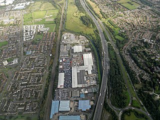
Cofton Hackett is a village and civil parish in the Bromsgrove District of north east Worcestershire, England. It is 10+1⁄4 miles southwest of the city centre of Birmingham and 16 miles (26 km) northeast of Worcester. In 2011, the village had a population of 1,893 but with housing development on the former Austin Rover site, this is expected to double over the five years to 2023. The village is served by two main bus services, these being the 20 and 145/145A operated by National Express and Diamond Bus respectively.

Marston Green is a village in the civil parish of Bickenhill and Marston Green, in the Metropolitan Borough of Solihull in the West Midlands. It lies within the historic county of Warwickshire. The village had a population of 5,000 in the 2011 Census.

Nechells is a district ward in central Birmingham, England, whose population in 2011 was 33,957. It is also a ward within the formal district of Ladywood. Nechells local government ward includes areas, for example parts of Birmingham city centre, which are not part of the historic district of Nechells as such, now often referred to in policy documents as "North Nechells, Bloomsbury and Duddeston".

Bournbrook is an industrial and residential district in southwest Birmingham, England, in the ward of Bournbrook and Selly Park and the parliamentary constituency of Birmingham Selly Oak. Before 2018 it was in Selly Oak Council Ward. Prior to what is commonly termed the Greater Birmingham Act, which came into effect on 9 November 1911, the Bourn Brook watercourse was the North Eastern boundary of Worcestershire, and the area was locally governed by the King's Norton and Northfield Urban District Council.

Wychbold is a village in the Wychavon district of Worcestershire. The village is situated on the A38 between Droitwich Spa and Bromsgrove, and by Junction 5 of the M5 motorway.

Barnt Green railway station serves the village of Barnt Green, North Worcestershire, England. It is situated 9+1⁄2 miles (15.3 km) south west of Birmingham New Street. The station, and all trains serving it, are operated by West Midlands Trains.

South Bromsgrove High School (SBHS) is a co-educational, upper school and sixth form with academy status, located in Bromsgrove, Worcestershire, England. It is located opposite the housing estate of Charford. The school delivers to GCSE, and A level students from an area between Alvechurch and Malvern with around 1,350 students on roll.

