Princetown is a village located within Dartmoor national park in the English county of Devon. It is the principal settlement of the civil parish of Dartmoor Forest. At the 2021 census, the village had a population of 1,443.

Worcestershire is a ceremonial county in the West Midlands of England. It is bordered by Shropshire, Staffordshire, and the West Midlands county to the north, Warwickshire to the east, Gloucestershire to the south, and Herefordshire to the west. The city of Worcester is the largest settlement and the county town.

Reston is a census-designated place in Fairfax County, Virginia, United States, and a principal city of both Northern Virginia and the Washington metropolitan area. As of the 2020 U.S. census, Reston's population was 63,226.

Bromsgrove is a town in Worcestershire, England, about 16 miles (26 km) north-east of Worcester and 13 miles (21 km) south-west of Birmingham city centre. It had a population of 34,755 in at the 2021 census. It gives its name to the wider Bromsgrove District, of which it is the largest town and administrative centre. In the Middle Ages, it was a small market town, primarily producing cloth through the early modern period. In the eighteenth and nineteenth centuries, it became a major centre for nail making.

Redditch is a town and non-metropolitan district with borough status in Worcestershire, England. It is located south of Birmingham, east of Bromsgrove, north-west of Alcester and north-east of Worcester. In 2021, the town had a population of 81,637 and the district had a population of 87,037. In the 1800s, it became a centre for the needle and fishing tackle industry; by the end of the century, 90% of the world's needles were manufactured in the town and its surrounding areas.

Malvern Link is an area in the civil parish of Malvern, in the Malvern Hills District, in Worcestershire, England to the north and east of Great Malvern. The centres of Malvern Link and Great Malvern are separated by Link Common, an area of open land that is statutorily protected by the Malvern Hills Conservators. The population of Link ward in 2022 was 6,301.

Bishan, also known as Peck San, Bishan New Town or Bishan Town, is a planning area and matured residential town located at the northernmost portion of the Central Region of Singapore. Statistically, the area is ranked the 38th biggest in terms of geographical size and the 22nd most populated planning area in the country. It is located at the most Central point of Singapore, and it comprises Upper Thomson, Marymount, Shunfu, Sin Ming, Bishan North and Bishan East. There are also many private residential properties in Bishan. Bishan is ranked 15th in terms of population density. Apart from its boundary with the Central Water Catchment in the west, Bishan borders three other planning areas: Ang Mo Kio to the north, Toa Payoh to the south, and Serangoon to the east.
Pambula is a town in Bega Valley Shire on the far south coast of New South Wales, Australia 454 kilometres (282 mi) south of Sydney via the Princes Highway. At the 2016 census, Pambula had a population of 970 people.

Houghton Regis is a market town and civil parish in the Central Bedfordshire district of Bedfordshire, England.

Wychbold is a village in the Wychavon district of Worcestershire. The village is situated on the A38 between Droitwich Spa and Bromsgrove, and by Junction 5 of the M5 motorway.
Wordsley is a suburban village near Stourbridge in the West Midlands, England. It is part of the Metropolitan Borough of Dudley and is north of the River Stour. Wordsley is part of the Kingswinford and South Staffordshire Parliamentary constituency as of 2024. It is bordered by open Staffordshire countryside to the west, Kingswinford to the north, Brierley Hill to the east and Stourbridge to the south.

Throckmorton is a small village and civil parish in the administrative district of Wychavon, in the county of Worcestershire, England.

Dickens Heath is a large modern village and civil parish in the borough of Solihull in the West Midlands and historic Warwickshire, incorporating the much older hamlet of Whitlocks End. It was previously part of the civil parish of Hockley Heath, and borders Cheswick Green and Tidbury Green in Solihull, as well as Major's Green in Worcestershire.
Bromsgrove District Council elections are held every four years. Bromsgrove District Council is the local authority for the non-metropolitan district of Bromsgrove in Worcestershire, England. Since the last boundary changes in 2015, 31 councillors are elected from 30 wards.

Fourth Ward is one of the historic six wards of Houston, Texas, United States. The Fourth Ward is located inside the 610 Loop directly west of and adjacent to Downtown Houston. The Fourth Ward is the site of Freedmen's Town, which was a post-U.S. Civil War community of African-Americans.
Wixams is a new town and civil parish located in Bedfordshire, England, which has been under construction since early 2007. It is expected to become the third largest settlement in the Borough of Bedford after Bedford itself and Kempston, and one of the largest new settlements founded in England since the British new towns movement of the first twenty five years after World War II.
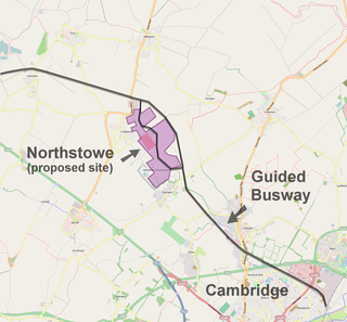
Northstowe is a new town in Cambridgeshire, England, forecast to have 24,400 residents in 10,000 homes. On 1 April 2021 Northstowe became a civil parish formed from Longstanton and Oakington and Westwick, with the first town council elected on 6 May of that year.
Redditch is a town and local government district in Worcestershire, England. The town is divided into separate districts. All street-name signs in Redditch have the street name in white lettering on a blue background and the district name in black lettering on a white background at the bottom of the sign. In the New Town areas, the roads are usually named in alphabetical order and house numbering in the cul-de-sac closes is consecutive, starting with number 1.

Dines Green is a northwestern suburb of Worcester in Worcestershire, England. It lies in the St. John ward in the west of the city. Initially developed as council housing, the estate now consists of a mix of council and privately owned homes: 49% of households were renting from the council or another landlord at the 2001 census.

The Leeds City Region, or informally Greater Leeds, is a local enterprise partnership city region located in West Yorkshire, England. Prior to the West Yorkshire devolution deal, the partnership covered parts of South and North Yorkshire. According to the Office for National Statistics, as of 2017 the city region ranked 2nd behind Greater London for both population and GVA in the United Kingdom. It has a population of 2,320,214 million and a GVA of £69.62 billion.

