Charlesbourg | |
---|---|
Motto(s): | |
Country | Canada |
Province | Quebec |
Metropolitan Community | Québec |
Established | 1 January 2002 |
Government | |
• Type | Borough |
• Mayor | Vincent Dufresne (2013-2017) |
Area | |
• Total | 66.43 km2 (25.65 sq mi) |
Population (2006) [1] | |
• Total | 72,810 |
Time zone | UTC-5 (EST) |
• Summer (DST) | UTC-4 (EDT) |
Charlesbourg is a borough of Quebec City, in the northeastern part of the city, west of the borough of Beauport.
The origins of Charlesbourg began with the concession of the seigniory of Notre-Dame-des-Anges in 1626. The seigniory extended from the Charles River [2] northward, encompassing the modern boroughs of Limoilou and Charlesbourg. In 1665, the new Intendant of Justice, Jean Talon, set out to establish three new villages further north on the plateau. That caused friction with the Jesuits who were the seignors of the area.
The first of the villages consisted of a 25-arpent square, in which a five-arpent square (the "trait carré") was reserved for the church, presbytery and cemetery. The homes of the settlers located on the periphery of the Trait Carré and their trapezoidal plots of land form a star shape. The second village, which is semicircular due to lack of space, was established just to the south at Petite-Auvergne and the third was established in 1667 in Bourg-Royal, to the northeast. This particular arrangement is still visible from the air and is the hallmark of Charlesbourg.
Charlesbourg is, first and foremost, an agricultural area, in addition to becoming a vacation destination for inhabitants of Quebec City in the first half of the 20th century. It became urbanized in the second half of the 20th century and became a suburb of Quebec City. In 1976, the municipalities of Charlesbourg-Est, Notre-Dame-des-Laurentides, Orsainville and the city of Charlesbourg were merged into the city of Charlesbourg. In 2002, Charlesbourg was in turn merged with other municipalities in Quebec City to form a new, large city. Charlesbourg became one of the boroughs of Quebec City. [3]
Charlesbourg's earlier name was Bourg Royal, but it was changed in honour of Charles Borromeo, its patron saint. [4] This Catholic saint was a leading figure of the Counter-Reformation combat against the Protestant Reformation.
An 18th-century British map depicts the place name Charlebourg. [5]
The territory of the borough is divided in six quarters, only two of which have official names: Notre-Dame-des-Laurentides and Des Jésuites. [6] The borough is also equally divided into five electoral districts for municipal elections. The quarters and districts do not correspond, unlike for other boroughs such as Beauport.
The other four quarters have numeric identifiers and will receive official names when neighborhood councils are formed and names are adopted.
Corresponds to the former city of Orsainville.
Corresponds to the former municipality of Charlesbourg-Est.
Includes the portion of the borough located west of Henri-Bourassa Boulevard, between the Corridor des Cheminots to the south and Jean-Talon Boulevard to the North. In particular, the historic borough of Charlesbourg - the Trait-Carré - with the Church of Saint-Charles-Borromée, listed as an historic monument in 1959, as well as the Magella-Paradis House and the Moulin des Jesuites.
Corresponds to the former parish of Saint-Rodrigue. It is bounded on the NNW by the Corridor des Cheminots, a cycle track located partly on an old railway track. It is a residential service area. The La Fourmilière Primary School dates back to the 1940s and the Catholic church dates to 1962. The "Les Galeries Charlebourg" shopping center and Loblaws supermarket were built on the site of an important fur trading post. The area is also home to the offices of the Quebec Ministry of Natural Resources.
This residential suburb of Quebec City is the fourth-largest urban centre of the Québec Urban Community. Like Beauport, it has increased by more than 20,000 people over the last 25 years.
According to the Canada 2006 Census:
The Legislative Council of Quebec was the unelected upper house of the bicameral legislature in the Canadian province of Quebec from 1867 to 1968. The Legislative Assembly was the elected lower house.
Lanaudière is one of the seventeen administrative regions of Quebec, Canada, situated immediately to the northeast of Montreal. It has a total population of 494,796 inhabitants, an increase of 4.9% over the 2011 census.
Quebec City is divided into six arrondissements or boroughs. These boroughs are the result of several waves of amalgamation and reorganization of the political boundaries of Quebec City.
Montmorency was a federal electoral district in the province of Quebec, Canada, that was represented in the House of Commons of Canada from 1867 to 1917, and from 1968 to 2004.
Beauport is a borough of Quebec City, Quebec, Canada on the Saint Lawrence River.
The Communauté métropolitaine de Québec (CMQ), or Quebec Metropolitan Community, is an administrative division of the province of Quebec, comprising the metropolitan area of Quebec City and Lévis. The CMQ is one of the two metropolitan communities of Quebec.
The Sir Wilfrid Laurier School Board is a school board headquartered in Rosemère, Quebec in Greater Montreal.
Quebec County was a historic county in the province of Quebec, Canada. The county included the Quebec City metropolitan area and extended northwestward. The county seat was Loretteville.
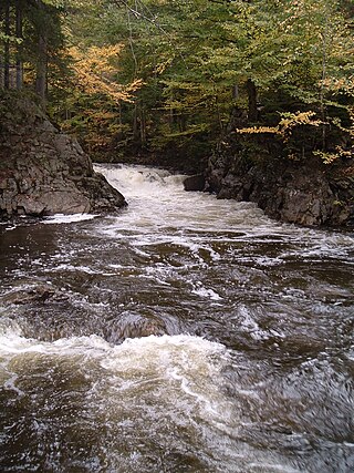
Réserve faunique des Laurentides, also known by its former name of parc des Laurentides, is a wildlife reserve in Quebec, Canada, located between Quebec City and the Saguenay–Lac-Saint-Jean region. This reserve is part of the network of wildlife reserves of Quebec (Canada) managed by the Ministry of Energy and Natural Resources (Quebec) and the Société des établissements de plein air du Québec. It is located halfway between Saguenay and Quebec.
The Centre de services scolaire des Samares is a francophone school district headquartered in Saint-Félix-de-Valois, in the Canadian province of Quebec. It comprises several primary schools and high schools across municipalities in the Lanaudière region. The commission is overseen by a board of elected school trustees.
The Communauté urbaine de Québec was a regional municipal body that existed in the area around Quebec City from 1970 to 2001.
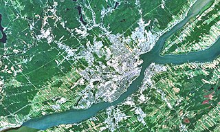
The Jaune River is a tributary of the Saint-Charles River flowing in the administrative region of Capitale-Nationale, in the province of Quebec, Canada. The course of the river crosses:
Quebec County was an electoral district of the Legislative Assembly of the Parliament of the Province of Canada, in Canada East, surrounding Quebec City. It was created in 1841 and was based on the previous electoral district of the same name for the Legislative Assembly of Lower Canada.
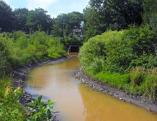
The Lairet River is a tributary of the Saint-Charles River, crossing Quebec City, Quebec, Canada. Over two kilometers long, it took its source in the vicinity of Charlesbourg and flowed in meanders in Limoilou. It has been completely channeled since the 1960s, except for a segment refitted in 2008.
This is a list of 78 federal electoral districts in the province of Quebec. New boundaries will be in effect for federal general elections called after April 22, 2024