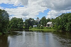
The Rock River is a tributary of Rock River Bay, an arm of Missisquoi Bay in the northern part of Lake Champlain. The river rises in the town of Franklin, in Franklin County, Vermont, United States, flows west into the town of Highgate, Vermont, and then north into Saint-Armand, Quebec, in the Brome-Missisquoi Regional County Municipality, administrative region of Montérégie, in the southwest of the province of Quebec, Canada. The river then turns south and re-enters Highgate, flowing into Rock River Bay north of Highgate Springs.

Trout River is a tributary of Chateauguay River, flowing in:
The Cap-Rouge river is a river flowing on the north shore of the Saint-Laurent river at the height of the Sainte-Foy–Sillery–Cap-Rouge borough of Quebec City and in the city of Saint-Augustin-de-Desmaures, both cities in the administrative region of Capitale-Nationale, in the province of Quebec, Canada.

The Rivière du Moulin, also called Rivière Langevin, is a tributary of the Saguenay River. Its mouth is located in the Rivière-du-Moulin district, in the east of the Chicoutimi borough in Saguenay. The river is known for its urban park, the Rivière-du-Moulin park, located on its banks near its mouth.

The rivière aux Sables is a river of the city of Saguenay (city), in the administrative region of Saguenay-Lac-Saint-Jean, in Quebec, in Canada. This watercourse constitutes one of the two outlets of Kenogami Lake; it flows north to flow into the Saguenay River. It is the only river that crosses Jonquière.

La Chevrotière is a tributary of the northwest shore of the Saint-Laurent river, descending in the municipality of Portneuf, Saint-Gilbert and Deschambault-Grondines, in the Portneuf, in the administrative region of Capitale-Nationale, in Quebec, in Canada.
The Saint-Jacques River is a tributary of the Portneuf River, flowing in the municipalities of Pont-Rouge and Saint-Basile, in the Portneuf Regional County Municipality, in the administrative region of Capitale-Nationale, in the province of Quebec, Canada.

The Rivière Portneuf is a tributary of the north shore of the Saint-Laurent river, crossing the municipalities of Saint-Raymond, Pont-Rouge, Sant-Basile and Portneuf, in the Portneuf Regional County Municipality, in the administrative region of the Capitale-Nationale, in the province of Quebec, in Canada.
The Jaune River is a tributary of the Saint-Charles River flowing in the administrative region of Capitale-Nationale, in the province of Quebec, Canada. The course of the river crosses:
The rivière Hibou is a tributary of the rivière des Hurons, flowing in the heart of the municipality of the townships of Stoneham-et-Tewkesbury, in the La Jacques-Cartier Regional County Municipality, in the administrative region of Capitale-Nationale, in the province of Quebec, in Canada.
The rivière du Mont Saint-Étienne is a tributary of the Sainte-Anne river, flowing on the north bank of the Saint Lawrence River, in the unorganized territory of Lac-Jacques-Cartier and the municipality of Saint-Ferréol-les-Neiges, in the La Côte-de-Beaupré Regional County Municipality, in the administrative region of Capitale-Nationale, in the province of Quebec, in Canada.
The Jean-Noël River is a tributary of the north shore of the Saint Lawrence River, in the administrative region of Capitale-Nationale, in the province of Quebec, in Canada. This river flows through the regional county municipalities (MRC) of:
Le Gros Bras is a tributary of the eastern bank of the lower part of the rivière du Gouffre, flowing in the unorganized territory of Lac-Pikauba and the municipality of Saint-Urbain, in the Charlevoix Regional County Municipality, in the administrative region of Capitale-Nationale, in the province of Quebec, in Canada. The upper part of this watercourse begins in Grands-Jardins National Park.

The Ouareau River is a tributary of the Assomption River crossing the administrative region of Lanaudière, in Quebec, in Canada.
The rivière de l'Esturgeon is a tributary of the Châteauguay River, flowing on the south shore of the Saint Lawrence River, in the administrative region of Montérégie, in the province of Quebec, in Canada. This river flows through the following municipalities:

The Hinchinbrook Brook is a tributary of the Châteauguay River, flowing on the south bank of the Saint Lawrence River, in:
The English River is a tributary of the Chateauguay River. This cross-border river between Canada and the United States crosses:
The Rivière aux Outardes Est is a tributary of the rivière aux Outardes. This cross-border river between Canada and the United States crosses:
The Rivière aux Outardes is a tributary of the Chateauguay River. It crosses the municipalities of Hinchinbrooke and Ormstown, in the Le Haut-Saint-Laurent Regional County Municipality, in the administrative region of Montérégie, in the province of Quebec, in Canada.
The Madeleine River is a tributary on the south shore of the Saint-Camille Brook whose current flows successively into the Nicolet Southwest River, the Nicolet River, Lake Saint-Pierre and St. Lawrence River. Its course flows in the municipalities of Dudswell (MRC Le Haut-Saint-François Regional County Municipality and Saint-Camille, in the Les Sources Regional County Municipality, in the administrative region of Estrie, in Quebec, in Canada.