Chavín de Pariarca District

Last updated • a couple of secsFrom Wikipedia, The Free Encyclopedia
Chavín de Pariarca
District

Chavin de Pariarca 00496.JPG

Chavín de Pariarca
Country Flag of Peru.svg  Peru
Region Huánuco
Province Huamalíes
Capital Chavín de Pariarca
Government
   Mayor Melanio Bocanegra Jaramillo
Area
  Total 89.25 km2 (34.46 sq mi)
Elevation 3,362 m (11,030 ft)
Population (2005 census)
  Total 4,862
  Density 54/km2 (140/sq mi)
Time zone PET (UTC-5)
UBIGEO 100503

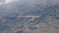
Chavín de Pariarca District is one of eleven districts of the province Huamalíes in Peru. [1]

Contents

Ethnic groups

The people in the district are mainly indigenous citizens of Quechua descent. Quechua is the language which the majority of the population (55.25%) learnt to speak in childhood, 43.63% of the residents started speaking using the Spanish language (2007 Peru Census). [2]

See also

Related Research Articles

References

  1. (in Spanish) Instituto Nacional de Estadística e Informática. Banco de Información Distrital Archived April 23, 2008, at the Wayback Machine .. Retrieved April 11, 2008.
  2. inei.gob.pe Archived January 27, 2013, at the Wayback Machine . INEI, Peru, Censos Nacionales 2007, Frequencias: Preguntas de Población: Idioma o lengua con el que aprendió hablar (in Spanish)

Coordinates: 9°25′33″S76°45′59″W / 9.4258°S 76.7664°W / -9.4258; -76.7664

Geographic coordinate system Coordinate system

A geographic coordinate system is a coordinate system that enables every location on Earth to be specified by a set of numbers, letters or symbols. The coordinates are often chosen such that one of the numbers represents a vertical position and two or three of the numbers represent a horizontal position; alternatively, a geographic position may be expressed in a combined three-dimensional Cartesian vector. A common choice of coordinates is latitude, longitude and elevation. To specify a location on a plane requires a map projection.