Volcanic cones are among the simplest volcanic landforms. They are built by ejecta from a volcanic vent, piling up around the vent in the shape of a cone with a central crater. Volcanic cones are of different types, depending upon the nature and size of the fragments ejected during the eruption. Types of volcanic cones include stratocones, spatter cones, tuff cones, and cinder cones.

Lassen Volcanic National Park is a national park of the United States in northeastern California. The dominant feature of the park is Lassen Peak, the largest plug dome volcano in the world and the southernmost volcano in the Cascade Range. Lassen Volcanic National Park is one of the few areas in the world where all four types of volcanoes can be found: plug dome, shield, cinder cone, and stratovolcano.

Cinder Cone is a cinder cone volcano in Lassen Volcanic National Park within the United States. It is located about 10 mi (16 km) northeast of Lassen Peak and provides an excellent view of Brokeoff Mountain, Lassen Peak, and Chaos Crags.

An active volcano is a volcano that has erupted during the Holocene, is currently erupting, or has the potential to erupt in the future. A volcano that is not currently erupting but could erupt in the future is known as a dormant volcano. Volcanoes that will not erupt again are known as extinct volcanoes.

Lava Butte is a cinder cone in central Oregon, United States, just west of U.S. Route 97 between the towns of Bend, and Sunriver in Deschutes County. It is part of a system of small cinder cones on the northwest flank of Newberry Volcano, a massive shield volcano which rises to the southeast. The cinder cone is capped by a crater which extends about 60 feet (20 m) deep beneath its south rim, and 160 feet (50 m) deep from the 5,020-foot (1,530 m) summit on its north side. Lava Butte is part of the Newberry National Volcanic Monument.

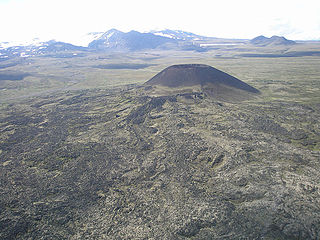
Eve Cone is a well-preserved black cinder cone on the Big Raven Plateau, British Columbia, Canada. It is one of the 30 cinder cones on the flanks of the massive shield volcano of Mount Edziza that formed in the year 700, making it one of the most recent eruptions on the Big Raven Plateau and in Canada. Eve Cone stands by itself in the middle of the Desolation Lava Field and its distinctive shape can be seen from a long distance. Eve Cone is covered by light yellow pumice from a close by but unknown vent.
Ivao Group is a group of cinder cones located in the southern part of the uninhabited, volcanic Urup Island, in the Kuril Archipelago, Russia.
Golets-Torny Group is a group of cinder cones located in the northern part of Iturup Island, Kuril Islands, Russia.
Lomonosov Group is a volcanic group of cinder cones located in the southern part of Paramushir Island, Kuril Islands, Russia.
The Atlin Volcanic Field, also called the Llangorse Volcanic Field and the Surprise Lake Volcanic Field, is a group of late-Pleistocene to Holocene cinder cones that lies on the Teslin Plateau east of Atlin Lake, Canada. The largest volcanic feature is the 1880-m-high Ruby Mountain which has been partially dissected by Pleistocene and post-Wisconsin glaciation. Two basaltic cinder cones at the heads of Cracker Creek and Volcanic Creek lie within glacially dissected U-shaped valleys and may be of postglacial age.

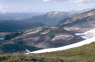
Cinder Cone is a cinder cone with a small crater on the west side of the Helm Glacier in Garibaldi Provincial Park in British Columbia, Canada. Cinder Cone is surrounded by cinder flats and its crater is filled with meltwater during the summer. Cinder Cone is eroded easily by meltwater during the spring, washing the pyroclastics into the Valley of Desolation. Cinder Cone produced a 9 km (6 mi) long lava flow during the early Holocene.
Ibex Mountain is a young cinder cone in the Yukon Territory, Canada, located 33 km southwest of Whitehorse and 12 km southeast of Mount Arkell. It is in a group of basaltic cones and lava flows called Alligator Lake volcanic complex and is in the Northern Cordilleran Volcanic Province. It is believed Ibex Mountain last erupted during the Pleistocene. Ibex Mountain is at the head of the Ibex River, which is southeast of Whitehorse. There is a road that runs close to Ibex Lake on the southeast side of the summit. From there is the hike to the summit of the cone.

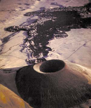
S P Crater is a cinder cone volcano in the San Francisco volcanic field, 25 miles (40 km) north of Flagstaff, Arizona, United States. It is surrounded by several other cinder cones which are older and more eroded. It is a striking feature on the local landscape, with a well-defined lava flow that extends for 4.3 miles (7 km) to the north. American astronauts use the crater to train for moonwalking.

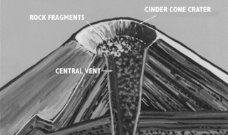
A cinder cone is a steep conical hill of loose pyroclastic fragments, such as volcanic clinkers, volcanic ash, or scoria that has been built around a volcanic vent. The pyroclastic fragments are formed by explosive eruptions or lava fountains from a single, typically cylindrical, vent. As the gas-charged lava is blown violently into the air, it breaks into small fragments that solidify and fall as either cinders, clinkers, or scoria around the vent to form a cone that often is symmetrical; with slopes between 30 and 40°; and a nearly circular ground plan. Most cinder cones have a bowl-shaped crater at the summit.
The Triplex Cones are a group of three cinder cones in northern British Columbia, Canada. They are thought to have last erupted during the Holocene epoch.

The Ulysses Fossae are a group of troughs in the Tharsis quadrangle of Mars at 10.06° north latitude and 123.07° west longitude. They were named after an albedo feature name. The area contains pitted cones called Ulysses Colles which were interpreted to be possible Martian equivalents to terrestrial cinder cones.
Snippaker Creek Cone is a cinder cone of the Iskut-Unuk River Cones group in northwestern British Columbia, Canada, located near the western flank of Cinder Mountain. It last erupted during the Holocene epoch.
Cone Glacier Volcano is a cinder cone in the Boundary Ranges of the Coast Mountains in northwestern British Columbia, Canada. It is part of the Iskut-Unuk River Cones group and last erupted during the Holocene period. Cone Glacier contains two arms that surround the volcano.

The Andagua volcanic field is a volcanic field in southern Peru which includes a number of cinder cones, lava domes and lava flows which have filled the Andagua Valley. The volcanic field is part of a larger volcanic province that clusters around the Colca River and is mostly of Pleistocene age, although the Andagua sector also features volcanic cones with historical activity, with the last eruption about 370 years ago. Eruptions were mostly effusive, generating lava flows, cones and small eruption columns. Future eruptions are possible, and there is ongoing fumarolic activity. Volcanic activity in the field has flooded the Andahua valley with lava flows, damming local watersheds in the Laguna de Chachas, Laguna Mamacocha and Laguna Pumajallo lakes and burying the course of the Andagua River. The Andahua valley segment of the larger volcanic province was declared a geopark in 2015.


