Cherry Street lift bridge

Last updated

Cherry Street lift bridge
Cherry St at Keating.JPG
Cherry Street lift bridge over the Keating Channel in 2008
Coordinates 43°38′51″N79°21′15″W / 43.64750°N 79.35417°W / 43.64750; -79.35417
Carriesvehicular and pedestrian
Crosses Keating Channel
Locale Toronto
OwnerCity of Toronto
Maintained by Toronto Port Authority
Characteristics
Design Bascule
Material Steel
Total length29 metres (95.1 ft)
Height48 metres (157.5 ft)
Clearance above (?) above deck
Clearance below No limit when the bridge is open
History
ArchitectR. M. Bremner
DesignerR. M. Bremner
Engineering design byR. M. Bremner, City of Toronto engineer
W. Sefton & Associates, Structural Engineer
Constructed by Ruliff Grass Construction Co. Ltd
Construction end1968
Location
Cherry Street lift bridge

The Cherry Street lift bridge over the Keating Channel was the smaller of two bascule lift bridges on Cherry Street, in Toronto, Ontario, Canada. The bridge spanned the canalized mouth of the Don River where it empties into Toronto Harbour. It was the fourth bridge at that location, before being replaced by the Cherry Street North bridge.

Contents

History

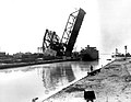
The City of Toronto government once operated a swing bridge over the Keating Channel at or near Cherry Street. The current bridge, constructed in 1968, is a vehicle and pedestrian bascule bridge, with a metal mesh deck. The original swing bridge was made of wood, and only carried a single rail line, operated by the Grand Trunk Railway.

The City solicited a bid for the first swing bridge in 1896. [1] Contractors were allowed to propose either a metal or wood bridge. The Privy Council of Canada approved funding of the bridge in 1900. [2] The two spans were 52 feet (15.85 m) long, which was considered sufficient to accommodate navigation on the river." The wooden bridge was replaced by steel draw bridges in 1912 and 1932. [3]

As originally constructed the bridge supported two lanes of traffic in each direction, and had a 1.8-metre (5.9 ft) sidewalk on the west side. [4] In 1995, several changes were made to provide "enhanced safety for cyclists, skaters, and pedestrians." As-built the entire deck of the bridge, including the sidewalk, was a steel mesh. In 1995 vehicle traffic was restricted to one lane in each direction to make room for a 2-metre (6.6 ft) sidewalk on the east side of the bridge, and the expansion of the sidewalk on the west side to 3.6 metres (12 ft) so it could accommodate bicycles as well as pedestrians. The sidewalks were faced with a non-slip plastic fibreglass surface.

In 2006, an inspection showed that the bridge required CA$2 million in repairs to corrosion damage. [5] The repairs were completed in April 2007. Key bearings in the bridge broke in 2010; it took time for replacement bearings to be found in Sweden. [6] The bridge wasn't restored to working order until June 27, 2011.

On August 1, 2019, the bridge failed to lower. It remained locked in its upright position for several weeks. [7] A crane was used to lower the bridge to the horizontal position. The bridge was quickly repaired, however its lifting mechanisms were badly damaged as a result. [8]

Future

The City of Toronto government's long-term plans are to "renaturalize" the mouth of the Don River. [9] Under this plan the Keating Channel will be retained, due to its historic value, but a new more natural-appearing channel would be constructed south of the Keating Channel. [10]

The current bridge was replaced by the new Cherry Street North bridges. The pre-fabricated spans for the two side-by-side bridges were delivered in 2022, and one of the spans was opened for road traffic in early 2024, while the other span will be reserved for a future light-rail transit. [11] [12] The bridge is currently being demolished.

See also

Related Research Articles

<span class="mw-page-title-main">Toronto waterfront</span> Shore of Lake Ontario in Toronto, Canada

The Toronto waterfront is the lakeshore of Lake Ontario in the city of Toronto, Ontario, Canada. It spans 46 kilometres between the mouth of Etobicoke Creek in the west and the Rouge River in the east.

<span class="mw-page-title-main">Arlington Memorial Bridge</span> Bridge in Washington, D.C.

The Arlington Memorial Bridge, often shortened to Memorial Bridge, is a Neoclassical masonry, steel, and stone arch bridge with a central bascule that crosses the Potomac River in Washington, D.C., the capital of the United States. First proposed in 1886, the bridge went unbuilt for decades thanks to political quarrels over whether the bridge should be a memorial, and to whom or what. Traffic problems associated with the dedication of the Tomb of the Unknown Soldier in November 1921 and the desire to build a bridge in time for the bicentennial of the birth of George Washington led to its construction in 1932.

<span class="mw-page-title-main">Morrison Bridge</span> Bridge in Oregon, U.S.

The Morrison Bridge is a bascule bridge that spans the Willamette River in Portland, Oregon. Completed in 1958, it is the third bridge at approximately the same site to carry that name. It is one of the most heavily used bridges in Portland. It was added to the National Register of Historic Places in November 2012.

<span class="mw-page-title-main">BNSF Railway Bridge 5.1</span> Railroad bridge in Portland, Oregon

The BNSF Railway Bridge 5.1, also known as the St. Johns Railroad Bridge or the Willamette River Railroad Bridge, is a through truss railway bridge with a vertical lift that spans the Willamette River in Portland, Oregon, United States. Built by the Spokane, Portland and Seattle Railway (SP&S) and completed in 1908, it was originally a swing-span bridge, and its swing-span section was the longest in the world at the time. However, 81 years later the main span was converted from a swing-type to a vertical-lift type, in order to widen the navigation channel. The lift span is one of the highest and longest in the world. The bridge consists of five sections, with the two sections closest to the bank on each side fixed.

<span class="mw-page-title-main">CRRNJ Newark Bay Bridge</span> Railroad bridge connecting Elizabethport and Bayonne

The Newark Bay Bridge of the Central Railroad of New Jersey (CNJ) was a railroad bridge in New Jersey that connected Elizabethport and Bayonne at the southern end of Newark Bay. Its third and final incarnation was a four-track vertical-lift design that opened in 1926, replacing a bascule bridge from 1904 which superseded the original swing bridge from 1887. The bridge served the main line of the CNJ, carrying daily interstate trains as well as commuter trains.

<span class="mw-page-title-main">Keating Channel</span> River in Ontario, Canada

The Keating Channel is a 1,000-metre (3,300 ft) long waterway in Toronto, Ontario, Canada. It connects the Don River to inner Toronto Harbour on Lake Ontario. The channel is named after Edward Henry Keating (1844-1912), a city engineer (1892-1898) who proposed the creation of the channel in 1893. The channel was built to connect Ashbridge's Bay to the harbour; later, the Don was diverted into the channel, and its river mouth infilled in the early 1910s.

<span class="mw-page-title-main">North Avenue Bridge</span> Bridge in Chicago, Illinois

The North Avenue Bridge can refer to one of three bridges that has carried North Avenue over the North Branch of the Chicago River on the north side of Chicago, Illinois. A center-pier swing bridge built in 1877 was replaced in 1907 by a bascule bridge, allowing river traffic more room for maneuvering in and out of the North Canal, just north of Goose Island.

<span class="mw-page-title-main">Port Lands</span> Neighbourhood in Toronto, Ontario, Canada

The Port Lands of Toronto, Ontario, Canada are an industrial and recreational neighbourhood located about 5 kilometres south-east of downtown, located on the former Don River delta and most of Ashbridge's Bay.

<span class="mw-page-title-main">Cortland Street Drawbridge</span> American bridge

The Cortland Street Drawbridge over the Chicago River is the original Chicago-style fixed-trunnion bascule bridge, designed by John Ericson and Edward Wilmann. When it opened in 1902, on Chicago's north side, it was the first such bridge built in the United States. The bridge was a major advance in American movable bridge engineering, and was the prototype for over 50 additional bridges in Chicago alone. The bridge was designated as an ASCE Civil Engineering Landmark in 1981, and a Chicago Landmark in 1991.

<span class="mw-page-title-main">Park Street Bridge</span> Bridge in San Francisco Bay Area

The Park Street Bridge is a double-leaf bascule drawbridge spanning 372 feet of the Oakland Estuary in the San Francisco Bay Area. It links the cities of Oakland and Alameda. In a year, the bridge is opened approximately 1700 times and carries approximately 40,000 vehicles per work day. It was built when the Oakland Estuary was trenched, converting Alameda from a peninsula to an island.

<span class="mw-page-title-main">Cherry Street Strauss Trunnion Bascule Bridge</span> Bascule bridge in Toronto, Canada

The Cherry Street Strauss Trunnion Bascule Bridge is a bascule bridge and Warren truss in Toronto, Ontario, Canada. Located in the industrial Port Lands area, it carries Cherry Street over the Toronto Harbour Ship Channel and opens to allow ships to access the channel and the turning basin beyond. There are two bascule bridges on Cherry Street. The other, smaller bridge, crosses the Keating Channel, while this bridge crosses the Ship Channel.

East Bayfront LRT, also known as the Waterfront East LRT, is a planned Toronto streetcar line that would serve the East Bayfront and Port Lands areas in Toronto, Ontario, Canada. It would run from Union station under Bay Street and along Queens Quay and Cherry Street to a new Villiers Loop along Commissioners Street east of Cherry Street on Villiers Island. It would complement the existing 509 Harbourfront service that connects Union Station to Queens Quay west of Bay Street. Longer-term plans are to extend the East Bayfront line from Cherry and Commissioners Streets to the planned East Harbour Transit Hub along GO Transit's Lakeshore East line and the planned Ontario Line.

<span class="mw-page-title-main">Cherry Street (Toronto)</span> Thoroughfare in Toronto, Ontario

Cherry Street is a north-south arterial roadway in the eastern downtown of Toronto, Ontario, Canada. It is situated in a former industrial area, that is now the site of redevelopment. It connects Eastern Avenue south to Lake Shore Boulevard, then to the Toronto Port Lands district, and terminates at Lake Ontario at Cherry Beach.

<span class="mw-page-title-main">Martin Luther King Bridge (Toledo, Ohio)</span> Bridge

The Martin Luther King Memorial Bridge is a double-leaf bascule bridge adjacent to downtown Toledo, Ohio, where Cherry Street crosses the Maumee River to become Main Street on the east side of the city. The structure opened to traffic in 1914.

<span class="mw-page-title-main">Cheboygan Bascule Bridge</span> Bridge in Cheboygan, Michigan

The Cheboygan Bascule Bridge, also known as the State Street Bridge, is a double-leaf bascule bridge in Cheboygan, Michigan, carrying U.S. Highway 23 across the Cheboygan River. Built in 1940, it was the last bascule bridge constructed in the state of Michigan prior to the end of World War II. It replaced an aging swing bridge built in 1877. The bridge is listed on the National Register of Historic Places.

<span class="mw-page-title-main">Bay Farm Island Bridge</span> Bridge in San Francisco Bay Area

The San Leandro Bay Bridge, better known as the Bay Farm Island Bridge, is a single-leaf bascule drawbridge spanning the San Leandro Channel, the inlet of San Leandro Bay within the San Francisco Bay Area, California, United States. It carries California State Route 61 and links the main island of Alameda with Bay Farm Island within the city of Alameda. The present bridge was completed in 1953; it is paralleled by a second bridge devoted to pedestrian and bicycle traffic, the Bay Farm Island Bicycle Bridge.

<span class="mw-page-title-main">Villiers Island</span> Island in Toronto, Ontario, Canada

Villiers Island is a 22-hectare (54-acre) area in Toronto's Port Lands being converted to an island. The project is a part of Port Lands Flood Protection Project by Waterfront Toronto. To prevent flooding from the Don River, a channel is being created to extend the river south and then west into Toronto Harbour providing another outlet and a more natural mouth for the Don River. The new channel effectively creates the island, which is also bounded by the Keating Channel and Toronto Harbour. Mixed-use residential development is planned for Villiers Island.

References

  1. "Notice to Contractors: Cherry Street Swing Bridge". Daily Mail and Empire . July 28, 1896. Retrieved March 22, 2012.
  2. "425q". Privy Council (Canada). 1900. Commons-logo.svg Media related to File:Order in Council authorizing the Cherry Street Swing Bridge.jpg at Wikimedia Commons
  3. "Appendix A: City of Toronto Inventory of Cultural Heritage Properties in Don Mouth Study Area" (PDF). Retrieved May 6, 2020. Bascule Bridge built in 1968 by City of Toronto' R. M. Bremner City Engineer; W. Sefton & Associates, Structural Engineer; Ruliff Grass Construction Co. Ltd; operator's control booth still in place; historical plaque underneath operator booth; concrete substructure of earlier bridge. A wooden draw bridge located over Don Diversion/Keating Channel at Cherry Street in 1899. Current bridge replaced an earlier steel draw bridges in 1912 and 1932.
  4. Virginia M. West (May 20, 1998). "Cherry Street Bridge - Enhanced Safety for Cyclists, Skaters and Pedestrians". City of Toronto government . Retrieved January 21, 2012.
  5. "Cherry Street Lift Bridge over the Keating Channel Structural Rehabilitation" (PDF). City of Toronto government. May 15, 2007. Retrieved January 21, 2012.
  6. Peter Kuitenbrouwer (July 30, 2011). "Old hands keep the Don flowing smoothly". National Post . Postmedia Network. Archived from the original on February 8, 2013. Retrieved January 2, 2012. The port can haul sludge out of the channel and into the lake only when the Cherry Street lift bridge is in its up position. In 2010, the lift bridge broke and the port could do no dredging at all.
  7. "Frustration mounts as Cherry Street bridge continues to malfunction". CBC News. August 4, 2019. Retrieved August 7, 2019.
  8. "Cherry Street bridge reopens after being stuck in vertical position for nearly 1 month". globalnews.ca. Global News. August 31, 2019.
  9. "Lower Don Lands Official Plan Amendments and Keating Channel Precinct West Zoning By-Law – Final Report" (PDF). City of Toronto government. August 11, 2010. Retrieved January 21, 2012.
  10. "Toronto Port Lands Company – Revitalization Opportunities for the Port Lands – Supplementary Report" (PDF). City of Toronto government. September 21, 2011. Retrieved January 21, 2012.
  11. McKinley, Steve (October 24, 2020). "Here comes the bridge: A sneak peek at Toronto's new Cherry St. bridge — set to make the trip from Nova Scotia". Toronto Star . Retrieved October 25, 2020.
  12. Mirabelli, Julian (August 9, 2018). "Eye-Catching Port Lands Bridges in the Works for Villiers Island". UrbanToronto . Retrieved October 25, 2020.