A viaduct is a specific type of bridge that consists of a series of arches, piers or columns supporting a long elevated railway or road. Typically a viaduct connects two points of roughly equal elevation, allowing direct overpass across a wide valley, road, river, or other low-lying terrain features and obstacles. The term viaduct is derived from the Latin via meaning "road", and ducere meaning "to lead". It is a 19th-century derivation from an analogy with ancient Roman aqueducts. Like the Roman aqueducts, many early viaducts comprised a series of arches of roughly equal length.

The Don River is a watercourse in southern Ontario that empties into Lake Ontario, at Toronto Harbour. Its mouth was just east of the street grid of the town of York, Upper Canada, the municipality that evolved into Toronto, Ontario. The Don is one of the major watercourses draining Toronto that have headwaters in the Oak Ridges Moraine.
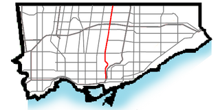
The Don Valley Parkway (DVP) is a municipal expressway in Toronto, Ontario, Canada, which connects the Gardiner Expressway in downtown Toronto with Highway 401. North of Highway 401, it continues as Highway 404. The parkway runs through the parklands of the Don River valley, after which it is named. It has a maximum speed limit of 90 km/h (56 mph) for its entire length of 15.0 km (9.3 mi). It is six lanes for most of its length, with eight lanes north of York Mills Road and four lanes south of Eastern Avenue. As a municipal road, it is patrolled by the Toronto Police Service.

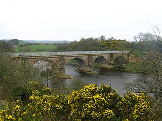
The Prince Edward Viaduct System, commonly referred to as the Bloor Viaduct, is the name of a truss arch bridge system in Toronto, Ontario, Canada, connecting Bloor Street East, on the west side of the system, with Danforth Avenue on the east. The system includes the Rosedale Valley phase and the Sherbourne Phase, an embankment built to extend Bloor Street East to the Rosedale Ravine from Sherbourne Street. The Don Valley phase of the system, the most recognizable, spans the Don River Valley, crossing over the Bayview Avenue Extension, the Don River, and the Don Valley Parkway.

Line 2 Bloor–Danforth is a subway line in the Toronto subway system, operated by the Toronto Transit Commission (TTC). It has 31 stations and is 26.2 kilometres (16.3 mi) in length. It opened on February 26, 1966, and extensions at both ends were completed in 1968 and again in 1980.

Line 1 Yonge–University is a rapid transit line of the Toronto subway. It serves Toronto and the neighbouring city of Vaughan in Ontario, Canada. It is operated by the Toronto Transit Commission, has 38 stations and is 38.4 km (23.9 mi) in length, making it the longest line on the subway system. It opened as the "Yonge subway" in 1954 as Canada's first underground passenger rail line and was extended multiple times between 1963 and 2017. As of 2010, Line 1 was the busiest rapid transit line in Canada, and one of the busiest lines in North America. In 2022, it averaged over 670,000 riders per weekday.

Rosedale is a station on Line 1 Yonge–University of the Toronto subway. It is located on the east side of Yonge Street at Crescent Road.

Sherbourne is a subway station on the Bloor–Danforth line in Toronto, Ontario, Canada. The station, which opened in 1966, is located west of Sherbourne Street on the south side of Bloor Street East. The station primarily serves the St. James Town neighbourhood and the southern portion of Rosedale. Wi-Fi service is available at this station. In December 2021, this station became an accessible subway station after undergoing renovations that began in August 2019.

Castle Frank is a station on Line 2 Bloor–Danforth of the Toronto subway. It is located at the northwest corner of Bloor Street East and Castle Frank Road. Wi-Fi service is available at this station.

The cancelled expressways in Toronto were a planned series of expressways in Toronto, Ontario, Canada that were only partially built or cancelled due to public opposition. The system of expressways was intended to spur or handle growth in the suburbs of Toronto, but were opposed by citizens within the city of Toronto proper, citing the demolition of homes and park lands, air pollution, noise and the high cost of construction. The Spadina Expressway, planned since the 1940s, was cancelled in 1971 after being only partially constructed. After the Spadina cancellation, other expressway plans, intended to create a 'ring' around the central core, were abandoned.

Bloor Street is an east–west arterial road in Toronto, Ontario, Canada. Bloor Street runs from the Prince Edward Viaduct, which spans the Don River Valley, westward into Mississauga where it ends at Central Parkway. East of the viaduct, Danforth Avenue continues along the same right-of-way. The street, approximately 25 kilometres (16 mi) long, contains a significant cross-sample of Toronto's ethnic communities. It is also home to Toronto's famous shopping street, the Mink Mile.

Danforth Avenue and Danforth Road are two historically-related arterial streets in Toronto, Ontario, Canada. Danforth Avenue is an east-west street that begins in Old Toronto at the Prince Edward Viaduct as a physical continuation of Bloor Street and continues for about 6 kilometres (3.7 mi) east through old Toronto, about 350 metres (1,150 ft) of old East York, and a further 5 kilometres (3.1 mi) in Scarborough until it intersects with Kingston Road via a ramped interchange. Danforth Road splits off the Avenue west of Warden Avenue and runs diagonally northeast until south of Lawrence Avenue, where it continues as McCowan Road.
Bayview Avenue is a major north–south route in the Greater Toronto Area of Ontario. North of Toronto, in York Region, Bayview is designated as York Regional Road 34.

Hoggs Hollow Bridge, originally known as the Yonge Boulevard Viaduct, is a set of four separate highway bridges that span the West Branch of the Don River Valley in Toronto, Ontario, Canada, and carries 14 lanes of Highway 401. The four structures are the busiest multi-span bridge crossing in North America, surpassing the Brooklyn Bridge.

Oriole GO Station is a small train station on GO Transit's Richmond Hill line. It is located under the Highway 401 overpass, west of Leslie Street in the North York district of Toronto, Ontario, Canada. It is approximately 500 metres (1,600 ft) south of Leslie subway station on Line 4 Sheppard of the Toronto Transit Commission.

The Leaside Bridge, formerly the East York Leaside Viaduct, and officially commemorated as the Confederation Bridge, is a truss bridge that spans the Don River in the City of Toronto, Ontario. Carrying six lanes of Millwood Road, it was built to connect the then Town of Leaside, including Thorncliffe Park, to the then Township of East York, and was completed on October 29, 1927. The construction time of only 10 months was record breaking at the time.

Castle Frank Brook is a buried creek and south-west flowing tributary of the Don River in central and north-western Toronto, Ontario, originating near the intersection of Lawrence Avenue and Dufferin Street.

The Toronto Transit Commission operated the Bloor streetcar line along Bloor Street and Danforth Avenue, extending at its longest from Jane Street in the west end of the city to Luttrell Avenue in the east. Both Luttrell and Jane loops at the termini were transfer points between streetcars and suburban bus routes. The line was abandoned in 1966 with the opening of the Bloor-Danforth subway line, except for two stubs of the line abandoned in 1968.

