Humber Bay Arch Bridge

Last updated
Humber Bay Arch Bridge
Toronto - ON - Humber Bay und Humber Bay Arch Bridge.jpg
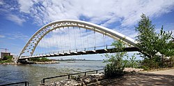
The Humber Bay Arch Bridge seen from the west bank of the Humber River
Coordinates 43°37′55″N79°28′16″W / 43.631896°N 79.471246°W / 43.631896; -79.471246
Carriespedestrian & bicycle traffic
Crosses Humber River
Locale Toronto
Maintained by Toronto Transportation Services [1]
Characteristics
DesignDouble-ribbed arch bridge [1]
MaterialSteel tubes [2]
Total length130 metres (430 ft) [2]
Height21.3 metres (70 ft) above grade [1]
Longest span100 metres (330 ft) [2]
No. of spans1
Piers in water0
History
DesignerMontgomery and Sisam Architects [1]
Construction end1994 [1]
Location
Humber Bay Arch Bridge

The Humber Bay Arch Bridge (also known as the Humber River Arch Bridge, the Humber River Pedestrian Bridge, or the Gateway Bridge) is a pedestrian and bicycle through arch bridge south of Lake Shore Boulevard West in Toronto, Ontario, Canada. Completed in the mid-1990s, the bridge is part of the Martin Goodman Trail and is 139 metres (456 ft) in length, with a clear span of 100 metres (330 ft) over the mouth of the Humber River to protect the environmental integrity of the waterway.

Contents

Design

Bridge from one portal Humber Bay Arch Bridge2.JPG
Bridge from one portal

The bridge is constructed of two 1,200 millimetres (47 in) diameter high-strength steel pipes, bent into twin arches that rise 21.3 metres (70 ft) above grade, and suspend the deck by way of 44 stainless-steel hangers, each 50 millimetres (2.0 in) in diameter. The foundation consists of concrete-filled caissons which go down 30 metres (98 ft) below grade to the bedrock. [1]

Designed in 1994 by Montgomery Sisam Architects of Toronto and Delcan Corporation (bridge engineers), it was constructed by Sonterlan Construction, and is the recipient of numerous local architectural, design and engineering awards. The bridge is situated at the mouth of the Humber River, the start of the "Toronto Carrying Place" trail, an ancient aboriginal trading route leading north, and thus features design elements and decorations such as carved turtles and canoes that evoke this native heritage.

The bridge forms an important pedestrian, recreational and commuter cyclist link, and carries the Waterfront Trail, a multi-use pathway that will eventually parallel the entire north shore of Lake Ontario. The Toronto section is known as the Martin Goodman Trail, and is one of the most popular pedestrian and cycling routes in the city.

See also

Related Research Articles

The Frederick G. Gardiner Expressway, commonly known as the Gardiner Expressway or simply the Gardiner, is a partially at grade and elevated municipal expressway in Toronto, Ontario, Canada. Running close to the shore of Lake Ontario, it extends from the foot of the Don Valley Parkway (DVP) in the east, just past the mouth of the Don River, to the junction of Highway 427 and the Queen Elizabeth Way (QEW) in the west, for a total length of 18.0 kilometres (11.2 mi). East of Dufferin Street to just east of the Don River, the roadway is elevated for a length of 6.8 kilometres (4.2 mi), unofficially making it the longest bridge in Ontario. It runs above Lake Shore Boulevard east of Spadina Avenue.

<span class="mw-page-title-main">Don River (Ontario)</span> River in Canada

The Don River is a watercourse in southern Ontario that empties into Lake Ontario, at Toronto Harbour. Its mouth was just east of the street grid of the town of York, Upper Canada, the municipality that evolved into Toronto, Ontario. The Don is one of the major watercourses draining Toronto that have headwaters in the Oak Ridges Moraine.

<span class="mw-page-title-main">Humber River (Ontario)</span> River in Canada

The Humber River is a river in Southern Ontario, Canada. It is in the Great Lakes Basin, is a tributary of Lake Ontario and is one of two major rivers on either side of the city of Toronto, the other being the Don River to the east. It was designated a Canadian Heritage River on September 24, 1999.

<span class="mw-page-title-main">Toronto waterfront</span> Shore of Lake Ontario in Toronto, Canada

The Toronto waterfront is the lakeshore of Lake Ontario in the city of Toronto, Ontario, Canada. It spans 46 kilometres between the mouth of Etobicoke Creek in the west and the Rouge River in the east.

<span class="mw-page-title-main">Mimico Creek</span> River in Ontario, Canada

Mimico Creek is a stream that flows through Brampton, Mississauga and Toronto in the Greater Toronto Area of Ontario, Canada. It is 33 kilometres (21 mi) long, is in the Great Lakes Basin, and is a tributary of Lake Ontario.

<span class="mw-page-title-main">Lake Shore Boulevard</span> Street in Toronto

Lake Shore Boulevard is a major arterial road running along more than half of the Lake Ontario waterfront in the city of Toronto, Ontario, Canada. Prior to 1998, two segments of Lake Shore Boulevard were designated as part of Highway 2, with the highway following the Gardiner Expressway between these two sections.

<span class="mw-page-title-main">Sunnyside, Toronto</span> Lakefront district

Sunnyside is a lakefront district in Toronto, Ontario, Canada. It includes a beach and park area along Lake Ontario's Humber Bay, from west of Exhibition Place to the mouth of the Humber River. The area has several recreation uses, including rowing clubs, sports clubs, picnic areas, playgrounds, a nightclub, a bathing pavilion and public pool. The area is a 3 kilometres (1.9 mi) long strip along the lakeshore, bounded by the Gardiner Expressway and rail lines, which separate it from the Parkdale, Roncesvalles and Swansea neighbourhoods to the north. The name originates in a local farm owned by John Howard, which was situated just to the north, on the location of the current St. Joseph's Health Centre hospital.

<span class="mw-page-title-main">Keating Channel</span> River in Ontario, Canada

The Keating Channel is a 1,000-metre (3,300 ft) long waterway in Toronto, Ontario, Canada. It connects the Don River to inner Toronto Harbour on Lake Ontario. The channel is named after Edward Henry Keating (1844-1912), a city engineer (1892-1898) who proposed the creation of the channel in 1893. The channel was built to connect Ashbridge's Bay to the harbour; later, the Don was diverted into the channel, and its river mouth infilled in the early 1910s.

<span class="mw-page-title-main">Humber Bay</span>

Humber Bay is a bay of Lake Ontario south of Toronto, Ontario, Canada. It is located between Ontario Place on the east and Mimico Creek to the west. The bay gives its name to Etobicoke's Humber Bay neighbourhood.

<span class="mw-page-title-main">The Queensway–Humber Bay</span> Neighbourhood in Toronto, Ontario, Canada

The Queensway–Humber Bay, known officially as Stonegate–Queensway, is a neighbourhood in the southwest of Toronto, Ontario, Canada. It is located in the southeast area of the former City of Etobicoke.

<span class="mw-page-title-main">Port Lands</span> Neighbourhood in Toronto, Ontario, Canada

The Port Lands of Toronto, Ontario, Canada are an industrial and recreational neighbourhood located about 5 kilometres south-east of downtown, located on the former Don River delta and most of Ashbridge's Bay.

<span class="mw-page-title-main">The Palace Pier</span> Site of two towers in Toronto, Ontario, Canada

The Palace Pier is the site of Palace Place and Palace Pier, two cruciform condominium towers tied for the 45th-tallest building in Toronto, Ontario, Canada. They are located at 2045 Lake Shore Boulevard West and 1 Palace Pier Court in the Humber Bay neighbourhood in the former city of Etobicoke.

<span class="mw-page-title-main">Sunnyside Amusement Park</span> Former amusement park in Toronto, Canada

Sunnyside Amusement Park was a popular amusement park in Toronto, Ontario, Canada that ran from 1922 to 1955, demolished in 1955 to facilitate the building of the Metro Toronto Gardiner Expressway project. It was located on the Lake Ontario waterfront at the foot of Roncesvalles Avenue, west of downtown Toronto.

<span class="mw-page-title-main">Cherry Street lift bridge</span> Bridge in Toronto

The Cherry Street lift bridge over the Keating Channel is the smaller of two bascule lift bridges on Cherry Street, in Toronto, Ontario, Canada. The bridge spans the canalized mouth of the Don River where it empties into Toronto Harbour. It is the fourth bridge at that location.

<span class="mw-page-title-main">Martin Goodman Trail</span> Multi-use path along the waterfront in Toronto, Canada

The Martin Goodman Trail is a 56 km (35 mi) multi-use path along the waterfront in Toronto, Ontario, Canada. It traverses the entire lake shore from one end of the city to the other, from Humber Bay Arch Bridge in the west to the Rouge River in the east. The Martin Goodman Trail is part of the 730 km Waterfront Trail around Lake Ontario.

<span class="mw-page-title-main">James D. Pfluger Pedestrian and Bicycle Bridge</span> Pedestrian bridge in Austin, Texas

The James D. Pfluger Pedestrian and Bicycle Bridge is a shared use bridge for pedestrians and cyclists spanning Lady Bird Lake in downtown Austin, Texas. Opened in 2001, the bridge connects the north and south sides of the Ann and Roy Butler Hike-and-Bike Trail and features an unusual "double curve" design. The bridge runs parallel to the Lamar Boulevard Bridge, which carries road traffic across the lake roughly 200 feet (61 m) to the west.

<span class="mw-page-title-main">Trillium Park</span>

Trillium Park is a park in Toronto owned and operated by the Government of Ontario. Various Ontario landscapes inspired the park design. The William G. Davis Trail passes through the park connecting it to the Martin Goodman Trail.

<span class="mw-page-title-main">Villiers Island</span> Island in Toronto, Ontario, Canada

Villiers Island is a 22-hectare (54-acre) area in Toronto's Port Lands being converted to an island. The project is a part of Port Lands Flood Protection Project by Waterfront Toronto. To prevent flooding from the Don River, a channel is being created to extend the river south and then west into Toronto Harbour providing another outlet and a more natural mouth for the Don River. The new channel effectively creates the island, which is also bounded by the Keating Channel and Toronto Harbour. Mixed-use residential development is planned for Villiers Island.

<span class="mw-page-title-main">Mosman Bay Sewage Aqueduct</span> Historic site in New South Wales, Australia

The Mosman Bay Sewage Aqueduct is a heritage-listed public pedestrian bridge and sewage aqueduct at Avenue Road, Mosman in the Mosman Council local government area of New South Wales, Australia. It was designed by Sewerage Construction Branch and NSW Department of Public Works and built from 1899 to 1901 by NSW Department of Public Works. It is also known as the Aqueduct over Mosman Bay. The property is owned by Sydney Water, an agency of the Government of New South Wales. It was added to the New South Wales State Heritage Register on 18 November 1999.

References

  1. 1 2 3 4 5 6 American Society of Civil Engineers (2007). Bridges 2008. ASCE. July bridge. ISBN   978-0-7844-0945-9.
  2. 1 2 3 Humber River Pedestrian-Bicycle Bridge at Structurae