Related Research Articles

Great Cheverell is a village and civil parish in Wiltshire, England, 5 miles (8.0 km) south of Devizes. In some sources the Latinized name of Cheverell Magna is used, especially when referring to the ecclesiastical parish.

Little Cheverell is a small village and civil parish in Wiltshire, England. In some sources the Latinized name of Cheverell Parva is used, especially when referring to the parish. The village lies on the B3098 Westbury–West Lavington road, which skirts the northern edge of Salisbury Plain, and is about 7+1⁄2 miles (12 km) east of Westbury and 5 miles (8 km) south of Devizes.
Great Cheverell Hill is a 33.2 hectare biological Site of Special Scientific Interest at Great Cheverell in Wiltshire, notified in 1971.

Cole railway station was a station on the Somerset and Dorset Railway in South Somerset, serving the village of Cole, which is now virtually joined to the village of Pitcombe and the small town of Bruton.

The Grapes is a Grade II listed public house at 39 Fairfield Street, Wandsworth, London, England.
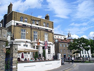
The White Cross is a Grade II listed public house at Riverside, Richmond, in the London Borough of Richmond upon Thames. It was built in the early mid-19th century, and the architect is not known.

The Britannia is a Grade II listed public house at 5 Brewers Lane, Richmond, in the London Borough of Richmond upon Thames.
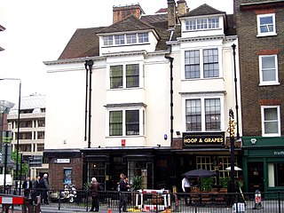
The Hoop and Grapes is a Grade II* listed public house at Aldgate High Street in the City of London.
The Crown is a Grade II listed public house at High Street, Cowley, London.

The Washington is a Grade II listed public house at 50 England's Lane, Belsize Park, London.

The White Swan is a Grade II listed public house at Twickenham Riverside in the London Borough of Richmond upon Thames.

The Rose and Crown is a Grade II listed public house at 199 Stoke Newington Church Street, Stoke Newington, Hackney, London, N16 9ES.

The Angel is a Grade II listed public house at 697 Uxbridge Road, Hayes, Middlesex, UB4 8HX.
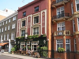
The Beehive is a grade II listed public house at 126 Crawford Street, London.

The principal war memorial in Enfield Town is the cenotaph that stands in Chase Green Gardens and is a grade II listed monument with Historic England. It commemorates men lost in both the World Wars as does a plaque in the town's main post office. In addition, in 2003 a memorial to those lost in the Arctic campaign of the Second World War was unveiled.

The George is a Grade II listed public house in Twickenham, in the London Borough of Richmond upon Thames. It is in three adjoining buildings at 32–36 King Street, parts of which date from the late 17th century.

The Fox is a pub at 39 Church Street, Twickenham, London TW1.

The Crown is a pub at 174 Richmond Road, Twickenham, London TW1. It is a Grade II listed building, dating back to the late 18th century.
Ayot Park is a grade II listed park and garden at Ayot St Lawrence in Hertfordshire, England. It contains the grade II* listed Ayot House along with an earlier manor house and a walled kitchen garden which are also listed.

The Spread Eagle, on the corner of Albert Street and Parkway, is a Grade II listed pub in Camden Town in the London Borough of Camden, London, England.
References
- ↑ Historic England. "Cheverells and attached stables (1100372)". National Heritage List for England . Retrieved 31 December 2018.
- ↑ "Cheverells - St Albans".
Coordinates: 51°49′39″N0°28′16″W / 51.82757°N 0.47123°W