Chiapas Depression dry forests

Last updated
Chiapas Depression dry forests
Morning at Sumidero Canyon.JPG
Chiapas Depression dry forests in Sumidero Canyon
Ecoregion NT0211.png
Ecoregion territory (in purple)
Ecology
Realm Neotropical
Biome tropical and subtropical dry broadleaf forests
Borders
Geography
Area13,974 km2 (5,395 sq mi)
Countries
Conservation
Conservation status Critical/Endangered [1]
Global 200 Mexican dry forests
Protected309 km² (2%) [2]

The Chiapas Depression dry forests form one of the ecoregions that belong to the tropical and subtropical dry broadleaf forests biome, as defined by the World Wildlife Fund, in northwestern Central America.

Contents

Geography

This ecoregion is located in the central Chiapas Depression, which lies between the Chiapas Highlands on the north and the Sierra Madre de Chiapas to the south. The Chiapas Depression is mostly within Chiapas state of Mexico, and extends into northwestern Guatemala. The depression is drained by the Grijalva River.

It covers an area of around 13,900 km2. [3] It lies at an elevation of 420–800 metres (1,380–2,620 ft).

Climate

The Chiapas Depression dry forests ecoregion has a hot, seasonally dry climate - warm sub-humid in the lowlands, transitioning to semi-warm humid on mountain slopes. It lies in the rain shadow of the Chiapas Highlands to the north and the Sierra Madre de Chiapas to the south, and is drier than the surrounding highlands and nearby lowlands. Much of the rainfall occurs in the summer, and there is a long dry season lasting four to six months. Average annual precipitation can be less than 800 mm in the driest areas. [4]

Flora

Tropical deciduous dry forest is the predominant plant community. Many trees lose their leaves during the long dry season, and the appearance of the forest changes dramatically between wet and dry seasons. The forests are generally low-canopied, and characteristic trees include Lysiloma divaricatum , Mexican alvaradoa ( Alvaradoa amorphoides ), peacock flower ( Caesalpinia pulcherrima ), ceiba or kapok ( Ceiba pentandra ), buttercup tree ( Cochlospermum vitifolium ), Comocladia engleriana , butterfly orchid tree ( Bauhinia divaricata ) and Bursera spp. Cactus and other succulent plants are common. [4]

Semi-deciduous and semi-evergreen forests of medium height are found in canyons and other areas with higher soil moisture, and in the northwestern transition to the Petén–Veracruz moist forests. Montezuma cypress (Taxodium mucronatum) and fig ( Ficus spp.) grow in riverine forests. [4]

There are areas of savanna in the central and northwestern parts of the ecoregion. Grasslands, including many introduced grasses, and palm groves are found in areas disturbed by human activity and livestock grazing. [4]

Its biodiversity is high, with about 980 plant species, and includes 40% of the endemic species of dry ecosystems found in Mexico. [3] It also forms a corridor that connects two major biogeographic region, the Gulf of Mexico on the east and the Pacific in the west.

Fauna

Native mammals include the gray fox (Urocyon cinereoargenteus), hooded skunk (Mephitis macroura), and hog-nosed skunk (Conepatus mesoleucos), particularly in isolated sierras and canyons less disturbed by human activity. [4]

Characteristic birds include the plain chachalaca (Ortalis vetula), mottled owl (Strix virgata), lesser roadrunner (Geococcyx velox), and white-throated magpie-jay (Calocitta formosa). [4]

Native snakes include the boa constrictor (Boa constrictor) and neotropical rattlesnake (Crotalus durissus). [4]

Conservation and threats

The ecoregion has been seriously threatened by cattle grazing, which is the main cause of its destruction, along with the effects of logging and the expansion of the agricultural frontier. [3]

Much of the ecoregion has been converted to cropland, including corn, beans, and peanuts, with sugarcane and corn in irrigated areas. Large areas have been cleared for pasturing cattle, which graze on introduced grasses. [4]

Tuxtla Gutiérrez is the largest city in the ecoregion. [4]

Protected areas

A 2017 assessment found that 309 km², or 2%, of the ecoregion is in protected areas. [2] Protected areas in the ecoregion include Sumidero Canyon National Park and a portion of La Sepultura Biosphere Reserve.

See also

Related Research Articles

<span class="mw-page-title-main">Sierra Madre Oriental</span> Mountain range in Mexico

The Sierra Madre Oriental is a mountain range in northeastern Mexico. The Sierra Madre Oriental is part of the American Cordillera, a chain of mountain ranges (cordillera) that consists of an almost continuous sequence of mountain ranges that form the western "backbone" of North America, Central America, South America, and Antarctica.

<span class="mw-page-title-main">Sierra Madre del Sur</span> Mountain range in southern Mexico

The Sierra Madre del Sur is a mountain range in southern Mexico, extending 1,000 kilometres (620 mi) from southern Michoacán east through Guerrero, to the Isthmus of Tehuantepec in eastern Oaxaca.

<span class="mw-page-title-main">Madrean pine–oak woodlands</span>

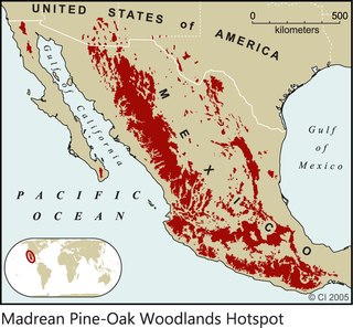
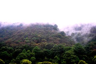
The Madrean pine–oak woodlands are subtropical woodlands found in the mountains of Mexico and the southwestern United States. They are a biogeographic region of the tropical and subtropical coniferous forests and temperate broadleaf and mixed forests biomes, located in North America.

<span class="mw-page-title-main">Sierra de la Laguna pine–oak forests</span> Ecoregion in Mexico

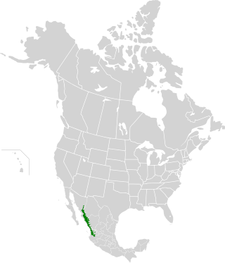
The Sierra de la Laguna pine–oak forests are a subtropical coniferous forest ecoregion, found in the Sierra de la Laguna mountain range at the southern tip of the Baja California Peninsula, Mexico.

<span class="mw-page-title-main">Sierra Madre de Chiapas</span> Mountain range in Central America

The Sierra Madre is a major mountain range in Central America. It is known as the Sierra Madre de Chiapas in Mexico. It crosses El Salvador, Guatemala, Mexico and Honduras. The Sierra Madre is part of the American Cordillera, a chain of mountain ranges that consists of an almost continuous sequence of mountain ranges that form the western "backbone" of North America, Central America, and South America.

<span class="mw-page-title-main">Petén–Veracruz moist forests</span> Tropical moist broadleaf forest ecoregion in Belize, Guatemala, and Mexico

The Petén–Veracruz moist forests is an ecoregion of the tropical and subtropical moist broadleaf forest biome found in Belize, Guatemala, and Mexico.

<span class="mw-page-title-main">Veracruz moist forests</span> Tropical moist broadleaf forests ecoregion of Mexico

The Veracruz moist forests is a tropical moist broadleaf forests ecoregion in eastern Mexico.

<span class="mw-page-title-main">Balsas dry forests</span> Tropical dry broadleaf forest ecoregion in Mexico

The Balsas dry forests is a tropical dry broadleaf forest ecoregion located in western and central Mexico.

<span class="mw-page-title-main">Central American pine–oak forests</span> Ecoregion in Mexico and Central America

The Central American pine–oak forests is a tropical and subtropical coniferous forests ecoregion in the mountains of northern Central America and Chiapas state in southern Mexico.

The Central America bioregion is a biogeographic region comprising southern Mexico and Central America.

<span class="mw-page-title-main">Sonoran–Sinaloan transition subtropical dry forest</span> Tropical and subtropical dry broadleaf forests ecoregion in Sonora and Sinaloa, Mexico

The Sonoran–Sinaloan transition subtropical dry forest is a tropical dry broadleaf forest ecoregion in northwestern Mexico.

<span class="mw-page-title-main">Central American dry forests</span> Tropical and subtropical dry broadleaf forests ecoregion in Central America

The Central American dry forests ecoregion, of the tropical and subtropical dry broadleaf forests biome, is located in Central America.

<span class="mw-page-title-main">Sinaloan dry forests</span> Tropical dry broadleaf forest ecoregion in Mexico

The Sinaloan dry forests is a tropical dry broadleaf forest ecoregion in western Mexico. It is the northernmost ecoregion of the Neotropical realm.

<span class="mw-page-title-main">Luzon montane rain forests</span> Ecoregion in Luzon, the Philippines

The Luzon montane rain forests is a tropical moist broadleaf forest ecoregion on the island of Luzon in the Philippines. The ecoregion is located on several volcanic and non-volcanic mountains of the island. Luzon is the largest and northernmost major island of the Philippines, located in the western Pacific Ocean.

<span class="mw-page-title-main">Southern Pacific dry forests</span> Tropical dry broadleaf forest ecoregion in Mexico

The Southern Pacific dry forests is a tropical dry broadleaf forest ecoregion in southern Mexico.

<span class="mw-page-title-main">Oaxacan montane forests</span> Ecoregion in Mexico

The Oaxacan montane forests is a tropical moist broadleaf forest ecoregion in eastern Mexico. It includes a belt of montane tropical forest on the eastern slope of the Sierra Madre de Oaxaca and eastern Trans-Mexican Volcanic Belt ranges. These forests lie between the lowland Petén–Veracruz moist forests and Veracruz moist forests, and the pine–oak forests of the higher mountains.

<span class="mw-page-title-main">Chimalapas montane forests</span> Tropical moist broadleaf forest ecoregion in Mexico

The Chimalapas montane forests is a tropical moist broadleaf forest ecoregion in southern Mexico. It includes the montane tropical forests of the Chimalapas region on the boundary of Chiapas and Oaxaca.

<span class="mw-page-title-main">Chiapas montane forests</span> Tropical moist broafleaf forest ecoregion of Chiapas, Mexico

The Chiapas montane forests is a tropical moist broadleaf forest ecoregion in southern Mexico and extending into western Guatemala. It includes the montane tropical forests on the northern and northeastern slopes of the Chiapas Highlands.

<span class="mw-page-title-main">Sierra Madre de Chiapas moist forests</span> Ecoregion in Mexico and Guatemala

The Sierra Madre de Chiapas moist forests is a tropical moist broadleaf forest ecoregion in southern Mexico and southern Guatemala, extending into the northwestern corner of El Salvador.

<span class="mw-page-title-main">Yucatán dry forests</span> Tropical dry broadleaf forest ecoregion in Mexico

The Yucatán dry forests is a tropical dry broadleaf forest ecoregion in southern Mexico. It includes the dry forests of the northwestern Yucatán Peninsula.

References

  1. "Chiapas Depression dry forests". Terrestrial Ecoregions. World Wildlife Fund. Retrieved 2013-08-24.
  2. 1 2 Dinerstein, Eric; Olson, David; et al. (June 2017). "An Ecoregion-Based Approach to Protecting Half the Terrestrial Realm". BioScience. 67 (6): 534–545. doi: 10.1093/biosci/bix014 . PMC   5451287 . PMID   28608869.{{cite journal}}: CS1 maint: date and year (link) Supplemental material 2 table S1b.
  3. 1 2 3 "Chiapas Depression dry forests". Fondo Mundial para la Naturaleza. Retrieved 2013-08-21.
  4. 1 2 3 4 5 6 7 8 9 Wiken, Ed, Francisco Jiménez Nava, and Glenn Griffith. 2011. North American Terrestrial Ecoregions—Level III. Commission for Environmental Cooperation, Montreal, Canada.