South Bruce Peninsula is a town at the base of the Bruce Peninsula of Ontario, Canada, in Bruce County between Lake Huron and Georgian Bay. It was formed on January 1, 1999, when the town of Wiarton, the village of Hepworth, and the townships of Albemarle and Amabel were amalgamated. The new municipality was created to provide necessary political representation, administrative support, and necessary municipal services on behalf of the residents.

Bruce County is a county in Southwestern Ontario, Canada. It has eight lower-tier municipalities with a total 2016 population of 66,491. It is named for James Bruce, 8th Earl of Elgin and 12th Earl of Kincardine, the sixth Governor General of the Province of Canada. The Bruce name is also linked to the Bruce Trail and the Bruce Peninsula.

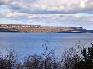
The Bruce Peninsula is a peninsula in Ontario, Canada, that divides Georgian Bay of Lake Huron from the lake's main basin. The peninsula extends roughly northwestwards from the rest of Southwestern Ontario, pointing towards Manitoulin Island, with which it forms the widest strait joining Georgian Bay to the rest of Lake Huron. The Bruce Peninsula contains part of the geological formation known as the Niagara Escarpment. The entire peninsula and nearby communities to the south along Lake Huron are located within Bruce County, Ontario.

Fathom Five National Marine Park is a National Marine Conservation Area in the Georgian Bay part of Lake Huron, Ontario, Canada, that seeks to protect and display shipwrecks and lighthouses, and conserve freshwater ecosystems. Parks Canada has management plans for the aquatic and terrestrial ecosystems, with a multi-action plan for species that are at risk, including endemic species, the Monarch butterfly, the eastern ribbonsnake, and the eastern whip-poor-will. The aquatic ecosystems in the park are also of particular interest. Many fish, shellfish, amphibians, and eels are an attraction for naturalists in the park. Much of this wildlife is accessible to scuba divers and snorkellers in the park. The many shipwrecks make the park a popular scuba diving destination, and glass bottom boat tours leave Tobermory regularly, allowing tourists to see the shipwrecks without having to get wet. Additionally, there are three main popular hiking trails found within Fathom Five National Marine Park that provides visitors with views of old growth forests and the Georgian Bay. The Saugeen Ojibway Peoples have inhabited the Bruce Peninsula and the area that is now Fathom Five National Marine Park for thousands of years. This land provided for their communities and their people with the plethora of wildlife and plant life. They provide the local knowledge about Lake Huron and its ecological value to the reserve, park, and their overall livelihood. Parks Canada and Saugeen Ojibway People's collaboration is said to yield a benefit to both parties with regard to overall ecosystem knowledge.
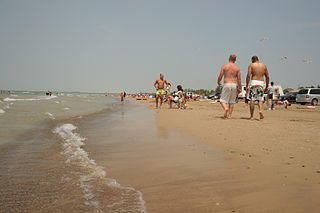
Sauble Beach is a beach community and unincorporated area in the town of South Bruce Peninsula, Bruce County, in the northern area of southwestern Ontario, Canada. It is on the Bruce Peninsula, along the eastern shore of Lake Huron, on the north edge of the Saugeen First Nation. The beach takes its name from that given by early French explorers to the sandy Sauble River, originally "La Rivière Au Sable" also indicating that the river emptied into Lake Huron at a sandy beach. The river was labelled with the French name on maps until 1881, when it became the Sauble River; in early years, a sawmill was built on the river, and later, a hydro electric plant.

Rondeau Provincial Park is the second oldest provincial park in Ontario, Canada, having been established with an order in council on 8 September 1894. The park is located in Southwestern Ontario, on an 8 km long crescentic sand spit extending into Lake Erie. Rondeau is home to the largest area of Carolinian forest in Canada, a long sand beach, a large marsh, approximately half of Rondeau Bay, campgrounds and a cottage community. The name of the park comes from the French words "ronde eau" or "round water" which describes the shape of the harbour sheltered by the peninsula.

Southampton is a community on the shores of Lake Huron in Bruce County, Ontario, Canada. It is close to Port Elgin and is located at the mouth of the Saugeen River in the Saugeen Ojibway Nation Territory. The size of the town is 6.44 square kilometres. The permanent population in 2016 was 3,678, but the summer population is higher since cottagers and campers spend vacation time in the area.
Saugeen First Nation is an Ojibway First Nation band located along the Saugeen River and Bruce Peninsula in Ontario, Canada. The band states that their legal name is the "Chippewas of Saugeen". Organized in the mid-1970s, Saugeen First Nation is the primary "political successor apparent" to the Chippewas of Saugeen Ojibway Territory; the other First Nation that is a part of Chippewas of Saugeen Ojibway Territory is Cape Croker. The Ojibway are of the Algonquian languages family. The First Nation consist of four reserves: Chief's Point 28, Saugeen 29, Saugeen Hunting Grounds 60A, and Saugeen and Cape Croker Fishing Islands 1.
Saugeen Shores is a town in Bruce County, Ontario, Canada, formed in 1998. In addition to the two main population centres of Southampton and Port Elgin, the town includes a portion of the village of Burgoyne and the North Bruce area, straddling the municipal eastern and southern boundary respectively. In 2016, the permanent population of Saugeen Shores was 13,715, in a land area of 171.05 square kilometres (66.04 sq mi).
Gibson Lake is a lake in Georgian Bay Township, District Municipality of Muskoka, Ontario, Canada. It is located 45 minutes north of the city of Barrie, and is accessed by Hwy 400 interchange # 174, just north of Six Mile Lake. Gibson Lake borders on the Wahta Mohawk Territory. The lake is 7 kilometres (4.3 mi) long, and flows into Georgian Bay via the Gibson River. The lake comprises two sections with the narrows connecting the North end to the South end. The southern areas of the lake are popular with cottagers from southern Ontario. The first cottagers purchased property here in the 1950s when the land was originally subdivided. There are presently 200 families on the lake with an increasing number of permanent residents. The north-east side of the lake is dominated by the Sahanatien Native Mohawk reserve which has seen much development in recent years. Many of the cottages on the north-east side are built on land leased from Wahta Mohawk families, and accessed by privately maintained roads.
The Robinson Treaties are two treaties signed between the Ojibwa chiefs and the Crown in 1850 in the Province of Canada. The first treaty involved Ojibwa chiefs along the north shore of Lake Superior, and is known as the Robinson Superior Treaty. The second treaty, signed two days later, included Ojibwa chiefs from along the eastern and northern shores of Lake Huron, and is known as the Robinson Huron Treaty. The Wiikwemkoong First Nation did not sign either treaty, and their land is considered "unceded".
The Saugeen Ojibway Nation Territory, also known as Saugeen Ojibway Nation, SON and the Chippewas of Saugeen Ojibway Territory, is the name applied to Chippewas of Nawash Unceded First Nation and Saugeen First Nation as a collective, represented by a joint council. The collective First Nations are Ojibway (Anishinaabe) peoples located on the eastern shores of Lake Huron on the Bruce Peninsula in Ontario, Canada. Though predominantly Ojibway, due to large influx of refugees from the south and west after the War of 1812, the descendants of the Chippewas of Saugeen Ojibway Territory also have ancestry traced to Odawa and Potawatomi peoples.
Chippewas of Nawash Unceded First Nation is an Anishinaabek First Nation from the Bruce Peninsula region in Ontario, Canada. Along with the Saugeen First Nation, they form the Saugeen Ojibway Nation. The Chippewas of Nawash Unceded First Nation had a registered membership of 2758 individuals, as of December 2020. Approximately 700 members live on the main reserve, Neyaashiinigmiing 27. The First Nation has 3 reserves, Neyaashiinigmiing 27, Cape Croker Hunting Ground 60B and Saugeen and Cape Croker Fishing Islands 1. The size of all reserves is 8083.70 hectares.
Charles Rankin, was an early Irish-born and Scottish-descended settler and land surveyor in Upper Canada. He is significant due to his role in the surveying and early settlement of large areas of Upper Canada, including much of the Bruce Peninsula and south shore of Lake Huron, and notably the city of Owen Sound. Born in 1797 at Enniskillen, County Fermanagh, Ireland, he died in either 1886 or 1888 in Owen Sound, a city whose founding he had been instrumental in.

Chantry Island is a small island in Lake Huron, south of the mouth of the Saugeen River and approximately a kilometre off the shores of the town of Southampton, Ontario. It is approximately 19 hectares in size and is a migratory bird sanctuary. Since the sanctuary territory extends 183 metres into the water surrounding the island, the total official area is listed as 63 hectares.
The Ojibway Nation of Saugeen is an Ojibwa First Nation in the Canadian province of Ontario. The Nation is located in the Thunder Bay District, approximately 20 kilometres northwest of Savant Lake. In December, 2007, its total registered population was 206, of which the on-reserve population was 72. The community maintains strong ties with Mishkeegogamang First Nation
Saugeen 29 is a First Nations reserve in Bruce County, Ontario. It is the main reserve of the Saugeen First Nation.
Saugeen Tract Agreement, registered as Crown Treaty Number 45+1⁄2, was signed August 9, 1836, between the Saugeen Ojibwa and Ottawa and the government of Upper Canada. Sir Francis Bond Head used this occasion for the provincial government's annual distribution of gifts to the Ojibwa and Ottawa of the Saugeen Peninsula to negotiate the treaty. In exchange for 1.5 million acres (6,070 km2) of land, the Ojibwa and Ottawa of Saugeen received only a promise to assist and protect Indians who took up residence on the Bruce Peninsula.
Saugeen and Cape Croker Fishing Islands 1 is a First Nations reserve consisting of 89 islands in Lake Huron off the western coast of the Bruce Peninsula in Ontario. They extend north of Chief's Point 28 for 11 miles (18 km) up to Pike Bay. These islands are shared between the Chippewas of Nawash Unceded First Nation and Saugeen First Nation.

Saugeen Hunting Grounds 60A is a First Nations reserve in Bruce County, Ontario. It is one of the reserves of the Saugeen First Nation.
