Related Research Articles
Ute may refer to:

Towaoc is a census-designated place (CDP) on the Ute Mountain Ute Tribe Reservation in Montezuma County, Colorado, United States. The population was 1,087 at the 2010 census. The Towaoc Post Office has the ZIP Code 81334.

Ouray ) was a Native American chief of the Tabeguache (Uncompahgre) band of the Ute tribe, then located in western Colorado. Because of his leadership ability, Ouray was acknowledged by the United States government as a chief of the Ute and he traveled to Washington, D.C. to negotiate for the welfare of the Utes. Raised in the culturally diverse town of Taos, Ouray learned to speak many languages that helped him in the negotiations, which were complicated by the manipulation of his grief over his five-year-old son lost during an attack by the Sioux. Ouray met with Presidents Lincoln, Grant, and Hayes and was called the man of peace because he sought to make treaties with settlers and the government.

The Four Corners is a region of the United States consisting of the southwestern corner of Colorado, southeastern corner of Utah, northeastern corner of Arizona, and northwestern corner of New Mexico. The Four Corners area is named after the quadripoint at the intersection of approximately 37° north latitude with 109° 03' west longitude, where the boundaries of the four states meet, and are marked by the Four Corners Monument. It is the only location in the United States where four states meet. Most of the Four Corners region belongs to semi-autonomous Native American nations, the largest of which is the Navajo Nation, followed by Hopi, Ute, and Zuni tribal reserves and nations. The Four Corners region is part of a larger region known as the Colorado Plateau and is mostly rural, rugged, and arid. In addition to the monument, commonly visited areas within Four Corners include Monument Valley, Mesa Verde National Park, Chaco Canyon, Canyons of the Ancients National Monument and Canyon de Chelly National Monument. The most populous city in the Four Corners region is Farmington, New Mexico, followed by Durango, Colorado.
U.S. Route 491 (US 491) is a north–south U.S. Highway serving the Four Corners region of the United States. One of the newest designations in the U.S. Highway System, it was created in 2003 as a renumbering of U.S. Route 666 (US 666). With the 666 designation, this road was nicknamed the "Devil's Highway" because of the significance of the number 666 to many Christian denominations, which believe it to be the Number of the Beast. This Satanic connotation, combined with a high fatality rate along the New Mexico portion, convinced some people the highway was cursed. The problem was compounded by persistent sign theft. These factors led to two efforts to renumber the highway, first by officials in Arizona, later in New Mexico. There have been safety improvement projects in recent years, and fatality rates have subsequently decreased.
Yucca House National Monument is a United States National Monument located in Montezuma County, Colorado between the towns of Towaoc and Cortez, Colorado. Yucca House is a large, unexcavated Ancestral Puebloan archaeological site.

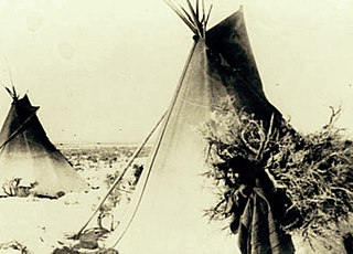
Ute people are Aboriginals of the Ute tribe and culture and are among the Great Basin classification of Indigenous People. They have lived in the regions of present-day Utah and Colorado for centuries. In addition to their home regions within Colorado and Utah, their hunting grounds extended into Wyoming, Oklahoma, Arizona, and New Mexico. They had sacred grounds outside of their home domain that were also visited seasonally.
The Ute Mountain Ute Tribe is one of three federally recognized tribes of the Ute Nation, and are mostly descendants of the historic Weeminuche Band who moved to the Southern Ute reservation in 1897. Their reservation is headquartered at Towaoc, Colorado on the Ute Mountain Ute Indian Reservation in southwestern Colorado, northwestern New Mexico and small sections of Utah.
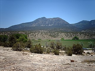
Ute Mountain, also known as Ute Peak or Sleeping Ute Mountain, is a peak within the Ute Mountains, a small mountain range in the southwestern corner of Colorado. It is on the northern edge of the Ute Mountain Ute Tribe Reservation. The Reservation forms the southwestern corner of the state and of Montezuma County.

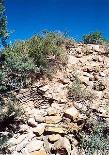
Cowboy Wash is a group of nine archaeological sites used by Ancient Puebloans in Montezuma County, southwestern Colorado, United States. Each site includes one to three pit houses, and was discovered in 1993 during an archaeological dig. The remains of twelve humans were found at one of the pit house sites, dating to the 12th century.

The Domínguez–Escalante expedition was a Spanish journey of exploration conducted in 1776 by two Franciscan priests, Atanasio Domínguez and Silvestre Vélez de Escalante, to find an overland route from Santa Fe, New Mexico, to their Roman Catholic mission in Monterey, on the coast of modern day central California. Domínguez, Vélez de Escalante, and Bernardo de Miera y Pacheco, acting as the expedition's cartographer, traveled with ten men from Santa Fe through many unexplored portions of the American West, including present-day western Colorado, Utah, and northern Arizona. Along part of the journey, they were aided by three indigenous guides of the Timpanogos tribe.

The Southern Ute Indian Reservation is a Native American reservation in southwestern Colorado near the northern New Mexico state line. Its territory consists of land from three counties; in descending order of surface area they are La Plata, Archuleta, and Montezuma Counties. The reservation has a land area of 1,058.785 sq mi (2,742.24 km²). Its largest communities are Ignacio and Arboles. The only other community that is recognized as a separate place by the Census Bureau is the CDP of Southern Ute, which lies just southeast of Ignacio.
The Timpanogos were a tribe of Native Americans who inhabited a large part of central Utah—particularly, the area from Utah Lake eastward to the Uinta Mountains and south into present-day Sanpete County. In some accounts they were called the Timpiavat, Timpanogot, Timpanogotzi, Timpannah, Tempenny and other names. During the mid-19th century, when Mormon pioneers entered the territory, the Timpanogos were one of the principal tribes in Utah based on population, area occupied and influence. Scholars have had difficulty identifying their language; most communication was carried out in Spanish or English, and many of their leaders spoke several native dialects of the Numic branch of the Uto-Aztecan language family.

Sapiah was the leader of the Southern Ute tribe from 1880 until his death in 1936. He was born around 1840 in the Ute lands before settlements. He was recognized as Chief of the Mauche and Servero Bands and Principal Chief of the Capote. He succeeded Chief Ouray as the official treaty negotiator. He learned English and took the "white man's name" Charles Buck, but he was best known as Buckskin Charley. He led the rescue of women and children who were abducted during the Meeker Massacre. In 1890, he was given the Rutherford Hayes Indian Peace Medal by President Benjamin Harrison. He rode with Geronimo in Theodore Roosevelt's 1905 Inaugural Parade. His son, Antonio Buck Sr., succeeded him as hereditary chief and became the first elected chairman of the Southern Ute tribe.
Pahvant was a band of Ute people that lived in present-day Utah. Called the "Water People", they fished and hunted waterfowl. They were also farmers and hunter-gatherers. In the 18th century they were known to be friendly and attentive, but after a chief's father was killed by emigrating white settlers, a group of Pahvant Utes killed John Williams Gunnison and seven of his men during his exploration of the area. The bodies of water of their homeland were dried up after Mormons had diverted the water for irrigation. Having intermarried with the Paiutes, they were absorbed into the Paiute Indian Tribe of Utah and relocated to reservations.

Chipeta or White Singing Bird was a Native American woman, and the second wife of Chief Ouray of the Uncompahgre Ute tribe. Born a Kiowa Apache, she was raised by the Utes in what is now Conejos, Colorado. An advisor and confidant of her husband, Chipeta continued as a leader of her people after his death in 1880.

The Uncompahgre Ute is a band of the Ute, a Native American tribe located in the US states of Colorado and Utah. It was formerly called the Tabeguache.
Ernest House Sr. was an American tribal leader who served as the Chairman of the Ute Mountain Ute Tribe for four four-year terms from 1982 to 2010.

The following outline is provided as an overview of and topical guide to the prehistoric people of Colorado, which covers the period of when Native Americans lived in Colorado prior to contact with the Domínguez–Escalante expedition in 1776. People's lifestyles included nomadic hunter-gatherering, semi-permanent village dwelling, and residing in pueblos.
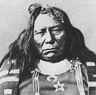
Colorow was a Ute chief of the Ute Mountain Utes, skilled horseman, and warrior. He was involved in treaty negotiations with the U.S. government. In 1879, he fought during the Meeker Massacre. Eight years later, his family members were attacked during Colorow's War. He was placed in the Jefferson County Hall of Fame in recognition of for the contributions that "he made to our county and, indeed, our state and nation."
References
- 1 2 Burnett, Sara (2011-09-19). ""Brilliant, courageous and inspired leader" Ernest House Sr. killed in motorcycle crash". Denver Post . Retrieved 2011-09-22.
| This biographical article about an Indigenous person of North America is a stub. You can help Wikipedia by expanding it. |