Indian Territory and the Indian Territories are terms that generally described an evolving land area set aside by the United States government for the relocation of Native Americans who held original Indian title to their land as an independent nation-state. The concept of an Indian territory was an outcome of the U.S. federal government's 18th- and 19th-century policy of Indian removal. After the American Civil War (1861–1865), the policy of the U.S. government was one of assimilation.

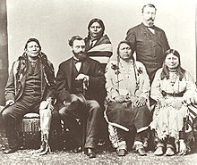
Ouray was a Native American chief of the Tabeguache (Uncompahgre) band of the Ute tribe, then located in western Colorado. Because of his leadership ability, Ouray was acknowledged by the United States government as a chief of the Ute and he traveled to Washington, D.C. to negotiate for the welfare of the Utes. Raised in the culturally diverse town of Taos, Ouray learned to speak many languages that helped him in the negotiations, which were complicated by the manipulation of his grief over his five-year-old son, abducted during an attack by the Sioux. Ouray met with Presidents Lincoln, Grant, and Hayes and was called the "man of peace" because he sought to make treaties with settlers and the government.

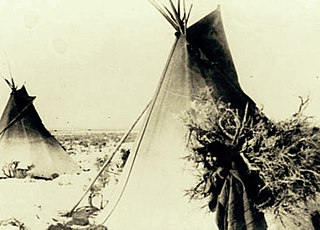
The Indigenous peoples of the Great Basin are Native Americans of the northern Great Basin, Snake River Plain, and upper Colorado River basin. The "Great Basin" is a cultural classification of indigenous peoples of the Americas and a cultural region located between the Rocky Mountains and the Sierra Nevada, in what is now Nevada, and parts of Oregon, California, Idaho, Wyoming, and Utah. The Great Basin region at the time of European contact was ~400,000 sq mi (1,000,000 km2). There is very little precipitation in the Great Basin area which affects the lifestyles and cultures of the inhabitants.
The Fort Hall Reservation is a Native American reservation of the federally recognized Shoshone-Bannock Tribes in the U.S. state of Idaho. This is one of five federally recognized tribes in the state. The reservation is located in southeastern Idaho on the Snake River Plain about 20 miles (32 km) north and west of Pocatello. It comprises 814.874 sq mi (2,110.51 km2) of land area in four counties: Bingham, Power, Bannock, and Caribou. To the east is the 60-mile-long (97 km) Portneuf Range; both Mount Putnam and South Putnam Mountain are located on the Fort Hall Reservation.

Ute are the indigenous, or Native American people, of the Ute tribe and culture among the Indigenous peoples of the Great Basin. They had lived in sovereignty for several hundred years in the regions of present-day Utah and Colorado.

The Ute Mountain Ute Tribe is one of three federally recognized tribes of the Ute Nation, and are mostly descendants of the historic Weeminuche Band who moved to the Southern Ute reservation in 1897. Their reservation is headquartered at Towaoc, Colorado on the Ute Mountain Ute Indian Reservation in southwestern Colorado, northwestern New Mexico and small sections of Utah.

Meeker Massacre, or Meeker Incident, White River War, Ute War, or the Ute Campaign), took place on September 29, 1879 in Colorado. Members of a band of Ute Indians attacked the Indian agency on their reservation, killing the Indian agent Nathan Meeker and his 10 male employees and taking five women and children as hostages. Meeker had been attempting to convert the Utes to Christianity, to make them farmers, and to prevent them from following their nomadic culture. On the same day as the massacre, United States Army forces were en route to the Agency from Fort Steele in Wyoming due to threats against Meeker. The Utes attacked U.S. troops led by Major Thomas T. Thornburgh at Milk Creek, 18 mi (29 km) north of present day Meeker, Colorado. They killed the major and 13 troops. Relief troops were called in and the Utes dispersed.

The Round Valley Indian Reservation is a federally recognized Indian reservation lying primarily in northern Mendocino County, California, United States. A small part of it extends northward into southern Trinity County. The total land area, including off-reservation trust land, is 93.939 km2. More than two-thirds of this area is off-reservation trust land, including about 405 acres (1.64 km2) in the community of Covelo. The total resident population as of the 2000 census was 300 persons, of whom 99 lived in Covelo.

The Southern Ute Indian Reservation is an Indian reservation in southwestern Colorado, United States, near the northern New Mexico state line. Its territory consists of land from three counties; in descending order of surface area they are La Plata, Archuleta, and Montezuma Counties. The reservation has a land area of 1,058.785 sq mi (2,742.24 km²). Its largest communities are Ignacio and Arboles. The only other community that is recognized as a separate place by the Census Bureau is the CDP of Southern Ute, which lies just southeast of Ignacio.

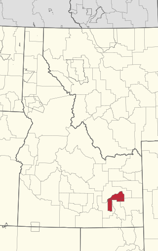
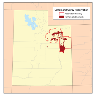
The Ute Indian Tribe of the Uinta and Ouray Reservation is a federally recognized tribe of Indians in northeastern Utah, United States. Three bands of Utes comprise the Ute Indian Tribe: the Whiteriver Band, the Uncompahgre Band and the Uintah Band. The Tribe has a membership of more than three thousand individuals, with over half living on the Uintah and Ouray Indian Reservation. The Ute Indian Tribe operates its own tribal government and oversees approximately 1.3 million acres of trust land which contains significant oil and gas deposits.
The Timpanogos are a tribe of Native Americans who inhabited a large part of central Utah, in particular, the area from Utah Lake east to the Uinta Mountains and south into present-day Sanpete County.

Cheyenne and Arapaho Indian Reservation were the lands granted the Southern Cheyenne and the Southern Arapaho by the United States under the Medicine Lodge Treaty signed in 1867. The tribes never lived on the land described in the treaty and did not want to.
Sapiah, is also commonly known as Charles Buck and Buckskin Charley, was the leader of the Southern Ute tribe from about 1870 until his death in 1936. He led a group of Utes to rescue women and children from the White River Agency during the Meeker Massacre (1879) that resulted in the deaths of Nathan Meeker and his soldiers. The northern band of Utes were forced out of Colorado after the massacre.
The Pahvant or Pahvants were a band of Ute people that lived in present-day Utah. Called the "Water People", they fished and hunted waterfowl. They were also farmers and hunter-gatherers. In the 18th century they were known to be friendly and attentive, but after a chief's father was killed by emigrating white settlers, a group of Pahvant Utes killed John Williams Gunnison and seven of his men during his exploration of the area. The bodies of water of their homeland were dried up after Mormons had diverted the water for irrigation. Having intermarried with the Paiutes, they were absorbed into the Paiute Indian Tribe of Utah and relocated to reservations.

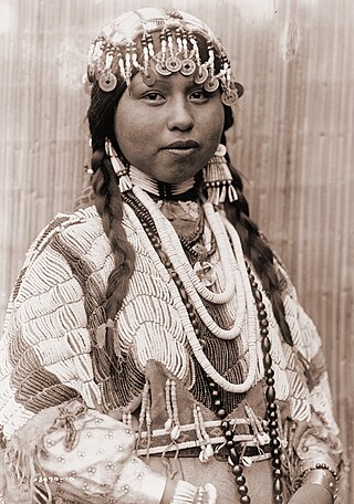
Chipeta or White Singing Bird was a Native American leader, and the second wife of Chief Ouray of the Uncompahgre Ute tribe. Born a Kiowa Apache, she was raised by the Utes in what is now Conejos, Colorado. An advisor and confidant of her husband, Chipeta continued as a leader of her people after his death in 1880.
The Native American peoples of Oregon are the set of Indigenous peoples who have inhabited or who still inhabit the area delineated in today's state of Oregon in the Pacific Northwest region of the United States. While the state of Oregon currently maintains relations with nine federally recognized tribal groups, the state was previously home to a much larger number of autonomous tribal groups, which today either no longer exist or have been absorbed into these larger confederated entities. Six of the nine tribes gained federal recognition in the late 20th century, after undergoing the termination and restoration of their treaty rights starting in the 1950s.
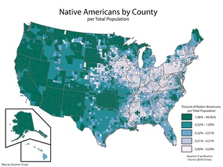
Indigenous peoples have lived in the area now known as the state of Utah for thousands of years. Today they are divided into five main groups: Utes, Goshutes, Paiutes, Shoshone, and Navajo. Each occupies a different region within the state, many of which regions extend across borders into other states. In the 2010 census, there were a total of 32,927 American Indian and Alaska Natives living within the state, which totaled to 1.19% of the total population of Utah.
The Seuvarits Utes are a band of the Northern Ute tribe of Native Americans that traditionally inhabited the area surrounding present-day Moab, Utah, near the Grand River and the Green River. The Seuvarits were among the Ute bands that were involved in the Black Hawk War. The Seuvarits and other Ute bands were eventually relocated onto reservations by the United States government after their population severely declined after exposure to disease and war during the latter half of the 19th century.

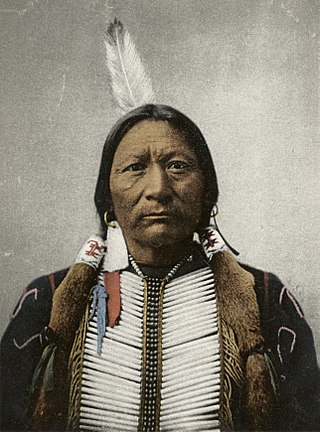
Nicaagat, also known as Chief, Captain and Ute Jack and Green Leaf. A Ute warrior and subchief, he led a Ute war party against the United States Army when it crossed Milk Creek onto the Ute reservation, which triggered the Battle of Milk Creek. Prior to the conflict, he had traveled to meet up with Major Thomas Tipton Thornburgh to learn of his intentions and warn him that crossing the Milk Creek onto the White River Ute reservation would be seen as an invasion and an act of war. When the army entered the reservation, a shooter from Nicaagat's band shot and killed Thornburgh.