Manitou Mineral Springs

Last updated

Manitou Springs Historic District
Manitou-Springs Shoshone-Spring 2012-10-21.JPG
Shoshone Spring, Manitou Avenue
USA Colorado location map.svg
Red pog.svg
Usa edcp location map.svg
Red pog.svg
Location Manitou Springs, Colorado
Coordinates 38°51′28″N104°55′14″W / 38.85778°N 104.92056°W / 38.85778; -104.92056
NRHP reference No. 83003516
Added to NRHP1983 [1]

Manitou Mineral Springs are natural mineral springs in Manitou Springs, Colorado and Cheyenne Spring House is on the National Register of Historic Places. [2] The springs are located in one of the country's largest National Historic Districts. [3]

Contents

Manitou Springs

Manitou Springs, also called "Saratoga of the West", [4] was established as a resort community, known for its mineral springs and "spectacular setting" at the edge of the Rocky Mountains [5] and the base of Pikes Peak. [3]

Geology

Rampart Range Rampart Range.JPG
Rampart Range

The spring water of Manitou Springs originates from two sources. "Deep-seated waters" of Rampart Range and Ute Pass provide one source of mineral water. Water below the surface is run through cavernous drainage systems called karst aquifers. Limestone in the water dissolves and resulting carbonic acid, or carbon dioxide, make the water "effervescent". The water rises to the surface naturally. This process is an artesian process where as water rises through layers of rock it picks up minerals and soda, or sodium bicarbonate. Some of the spring water also comes from "surface" waters from the watershed basins of Fountain Creek and Williams Canyon. Each spring has a different mineral content and because of that, a different taste. [6] [7]

History

Navajo and Manitou springs, Colorado, from Robert N. Dennis collection of stereoscopic views Navajo and Manitou Springs.png
Navajo and Manitou springs, Colorado, from Robert N. Dennis collection of stereoscopic views
Valley of springs where Ute came to hunt and use the mineral springs. The center of the photograph shows a "lone encampment" of Ute Native Americans, between 1874 and 1879. Future Manitou Springs, photograph 1874-1879.png
Valley of springs where Ute came to hunt and use the mineral springs. The center of the photograph shows a "lone encampment" of Ute Native Americans, between 1874 and 1879.
Soda spring, 1870 Soda spring, Manitou. El Paso County, Colorado - NARA - 517214.tif
Soda spring, 1870

The town has several mineral springs, called manitou for the "breath of the Great Spirit Manitou" believed to have created the bubbles, or "effervescence", in the spring water. The springs were considered sacred grounds where Native Americans drank and soaked in the mineral water to replenish and heal themselves. Ute, Arapaho, Cheyenne and other plains tribes came to the area, spent winters there, and "share[d] in the gifts of the waters without worry of conflict." There were 9 or 10 natural springs. As whites moved in there were "skirmishes" for access to the historical resort area until the Native Americans were removed from the area and placed on reservations. [5] [7] [8] [9]

Explorer Stephen Harriman Long made note of the water's healing properties in 1820. [8] His expedition's botanist and geologist, Edwin James, noted the healing benefits of the water; He was also the first European man believed to have climbed Pikes Peak. George Frederick Ruxton wrote of the "boiling waters" in a book about his travels. [10] Recognizing the extent to which Native Americans considered the site to be sacred, Ruxton wrote: "...the basin of the spring (at Manitou) was filled with beads and wampum, and pieces of red cloth and knives, while the surrounding trees were hung with strips of deer skin, cloth and moccosons (sic)." [11]

Forty-eight years later, a plan for a health resort was developed by Dr. William Abraham Bell and William Jackson Palmer, a general during the Civil War: [5] [8] "They had a vision of dreamy summer villas nestled in the mountains, with grand hotels and landscaped parks clustered around the springs." Railroad transportation brought people into the area, first called Fountain Colony and La Font. The town wasn't built at envisioned by the two men, storefronts and homes were built in the town. It became the first resort town in the state. [12] [13] [nb 1]

In 1873 Henry McAllister, a developer working for Palmer, touted the medicinal benefits of the springs and that Manitou Springs had the necessary components of a successful spa resort, including "incomparable climate and scenery". [5] [8]

Medical practitioners, such as Dr. Edwin Solly, promoted the health benefits of the "pure air" and sunny Rocky Mountain climate as the "world's best suited therapeutic environment" for the treatment of tuberculosis. [15] He also believed in the benefits of mineral spring water which drew tourists and the infirm, particularly people with tuberculosis, to the area. Some springs were enclosed as the town grew. One of the enclosures, in red sandstone and under a "conical roofed structure", is the Cheyenne Spring House. There were more than 50 drilled wells and springs after the turn of the century. Since then, more were enclosed. After a period when the town's popularity diminished, some springs were closed, capped or paved over. Then the Mineral Springs Foundation was formed in 1987 to restore some of the springs and promote the benefits of the town's spring water. Walking tours of the town's springs are called "Springabouts". [5] [8] [9]

Manitou Springs water was sold "worldwide". [16]

Springs

Cheyenne Spring House, Manitou Avenue Cheyenne Spring House 3.JPG
Cheyenne Spring House, Manitou Avenue
7 Minute Spring, October 21, 2012 Manitou-Springs 7-Minute-Spring 2012-10-21.JPG
7 Minute Spring, October 21, 2012
Shoshone Spring, Manitou Avenue Shoshone Spring 2.JPG
Shoshone Spring, Manitou Avenue
Twin Spring, Ruxton Avenue Twin Spring.JPG
Twin Spring, Ruxton Avenue
Stratton Spring, October 21, 2012 Manitou-Springs Stratton-Spring 2012-10-21.JPG
Stratton Spring, October 21, 2012

7 Minute Spring

The 7 Minute Spring was drilled near the former Manitou House Hotel in 1909. Every 7 minutes a geyser erupted. In 1993 a park was developed surrounding a newly drilled spring. Don Green, Maxine Green, and Bill Burgess collaborated on two fonts at the spring. [6]

Cheyenne Spring House

Cheyenne Spring House, near the Navajo Spring and the Spa, was built in the 1890s of red sandstone. It is a soda spring. Like the Navajo Spring, it has a high overall mineral content, but not a high content of any specific mineral. The building was constructed by the Manitou Mineral Water company. [6] [17] Its sweet water comes from limestone aquifers thought to be more than 20,000 years old and located about one mile below the surface. [18] The spring's water is available to the public in the bronze sculpture by Paul Rogers that stands a few feet from the spring house.

Iron Spring Geyser

The Iron Spring Geyser was drilled on Ruxton Avenue in 1910 by Joseph Hiestand to increase the availability of iron-rich mineral water, also known as a chalybeate water, in the town. The spring water also contains a high content of fluoride, silica, sodium and potassium. [6] [17] In the 1880s "health seekers" stopped at the spring during their daily walk. [18]

Previously, the spring would erupt every 45 minutes and shoot up to 7 feet into the air. It was located in the Navajo Geyser Pavilion. The spring which is privately owned was restored in 2006, but ceased to flow in later years. There is now no sign of the Spring in the Manitou Outpost store building where the guide's photo displayed it. The spring was plugged and a sidewalk was paved over it. The spring was later renovated into the hand pump that exists today. [18]

Native Americans and early settlers came to the Navajo Spring along the Ute Trail to take the water believed to have healing powers. Its water supplied the local bathhouse and was the source of the bottled spring water sold as "Ginger Champagne" and "Manitou Table Water". In general, the water has a high mineral content, but does not have an exceeding level of any particular minerals. The spring font, designed by Chris Dysart, is located behind the Patsy's popcorn kiosk on Manitou Avenue. [6] [17] [19]

Shoshone Spring

Shoshone Spring's spring house, built in the 1890s, is located on Manitou Avenue. It has the "greatest amount of deep-seated water from the karst aquifer system and the highest mineral content of the town's springs, and particularly high content of chloride, calcium, alkalinity, lithium, manganese and zinc. Because of its high mineral content, it was considered the most "medicinal" of Manitou's springs, partly because of its sulphur content. The spring house was constructed of red sandstone from the nearby Kenmuir Quarry, which is now the Red Rock Canyon Open Space. [6] [17] [18] [20]

Soda Spring

Soda Spring is one of the natural springs in Manitou Springs and once in an open air pavilion, the spring is located now in the Spa building [18] basement.

Stratton Spring

Stratton Spring, named for Winfield Scott Stratton, was drilled in 1936 by the Stratton Foundation. It is located at "the loop", a circular intersection at the end of Manitou Avenue, which was the end of the avenue's railroad car line in the early 20th century. A sculpture, created by Fred Darpino, is located at the site. [6] [18]

Twin Spring

Located on Ruxton Avenue, Twin Spring combines waters from two different depths and flow from one font. The spring was once called Twin Lithia Springs, as Lithium is present in the spring water at a concentration of .233 mg/L. [21] The water, high in magnesium, is considered a "sweet" water, used by locals to make lemonade. Aside from the pleasing taste, it is also sought for its potassium and calcium content. The spring was drilled by William S. Crosby in the 1920s. [6] [17] [18]

Ute Chief Spring

The spring, located at the far western end of Manitou Avenue, is a privately owned spring. A sculpture, created by Steve Titus, of a Native American man symbolizes the historic use of advertising sculptures established around town to promote bottled Ute Chief Mineral Water. The metal sculpture is a replica of the original plaster sculpture of the same design that was on the site in the first half of the twentieth century. The Ute Chief Spring no longer flows. [6] [17]

Wheeler Spring

The spring was drilled in 1920 by the son-in-law of Jerome B. Wheeler, an investor in Aspen and Manitou Springs, Colorado, creating the Manitou Mineral Water bottling plant and building the Wheeler Clock on Manitou Avenue. (He also built the Hotel Jerome in Aspen.) The spring is located near the location of his home, Windemere, which is where the United States Post Office is now located. [6] [17] [18]

See also

Notes

  1. In addition to their development investments in Colorado Springs and Manitou Springs, Bell and Palmer invested in the Denver and Rio Grande Western Railroad to bring tourists to the towns of Colorado Springs and Manitou Springs from Denver. Bell, who was British, encouraged so many people from his homeland to visit the Pikes Peak area that Colorado Springs became known and "Little London". Horses and buggies at the railroad station in Colorado Springs transported visitors to Manitou Springs. [14]

Related Research Articles

<span class="mw-page-title-main">Manitou Springs, Colorado</span> City in Colorado, United States

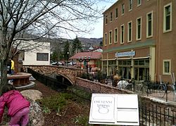
Manitou Springs is a home rule municipality located at the foot of Pikes Peak in western El Paso County, Colorado, United States. The town was founded for its natural mineral springs. The downtown area continues to be of interest to travelers, particularly in the summer, with many shops and restaurants, as well as a creekside city park. The main road through the center of town was one of the direct paths to the base of Pikes Peak. Barr Trail, which winds its way up Pikes Peak, is accessible from town. The subdivision Crystal Hills was added to the municipality in the 1960s.

<span class="mw-page-title-main">Garden of the Gods</span> Protected rock formation near Colorado Springs, Colorado

Garden of the Gods is a 1,341.3 acre public park located in Colorado Springs, Colorado, United States. 862 acres of the park was designated a National Natural Landmark in 1971.

The Ute Pass is a mountain pass west of Colorado Springs that ranges from a peak elevation at Divide of 9,165 to 6,165 feet at its lowest point.

<span class="mw-page-title-main">Cascade, Colorado</span> Unincorporated community in State of Colorado, United States

Cascade is an unincorporated community and U.S. Post Office in El Paso County, Colorado, United States. The ZIP Code of the Cascade Post Office is 80809.

<span class="mw-page-title-main">History of Colorado Springs, Colorado</span> Place in Colorado, United States

Before it was founded, the site of modern-day Colorado Springs, Colorado, was part of the American frontier. Old Colorado City, built in 1859 during the Pike's Peak Gold Rush was the Colorado Territory capital. The town of Colorado Springs was founded by General William Jackson Palmer as a resort town. Old Colorado City was annexed into Colorado Springs. Railroads brought tourists and visitors to the area from other parts of the United States and abroad. The city was noted for junctions for seven railways: Denver and Rio Grande (1870), Denver and New Orleans Manitou Branch (1882), Colorado Midland (1886-1918), Colorado Springs and Interurban, Atchison, Topeka, and Santa Fe (1889), Rock Island (1889), and Colorado Springs and Cripple Creek Railways. It was also known for mining exchanges and brokers for the Cripple Creek Gold Rush.

<span class="mw-page-title-main">Barr Trail</span>

Barr Trail is a 13-mile (21 km) trail in the Pike National Forest that begins in Manitou Springs, Colorado and ends at the Pikes Peak summit. The high elevation trail with a long sustained grade is rated more difficult by the U.S. Forest Service. With a 7,800 feet (2,400 m) elevation gain to reach the summit, the Colorado Springs Convention & Visitors Bureau states that it is an advanced trail and is the most difficult trail in the Pikes Peak region.

<span class="mw-page-title-main">Briarhurst</span> Historic house in Colorado, United States

Briarhurst Manor, also known as William A. Bell House, is a finely grained pink Victorian sandstone manor house listed on the National Register of Historic Places in the city of Manitou Springs, Colorado. It is the second building on this site.

<span class="mw-page-title-main">George Ruxton</span> British botanist, geologist and explorer

George Frederick Ruxton was a British explorer and travel writer. He was a lieutenant in the British Army, received a medal for gallantry from Queen Isabella II of Spain, was a hunter and explorer and published papers and books about his travels to Africa, Canada, Mexico and the United States.

<span class="mw-page-title-main">Uncompahgre Ute</span>

The Uncompahgre Ute or ꞌAkaꞌ-páa-gharʉrʉ Núuchi is a band of the Ute, a Native American tribe located in the US states of Colorado and Utah. In the Ute language, uncompahgre means "rocks that make water red." The band was formerly called the Tabeguache.

Ivywild, Colorado, is a subdivision of Colorado Springs south of the downtown, west of Cascade Avenue and along Cheyenne Creek. As of 2015, the United States Geological Survey defines Ivywild as a Populated Place. It is one of the city's oldest working-class neighborhoods.

<span class="mw-page-title-main">First Congregational Church (Manitou Springs, Colorado)</span> Historic church in Colorado, United States

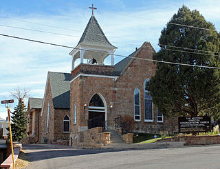
First Congregational Church is a historic church at 101 Pawnee Avenue in Manitou Springs, Colorado. Completed in August 1880, it was the first church built in Manitou Springs and is the oldest continuously operated Congregational church in Colorado. Due to an influx of tourists during the summer, it was enlarged in 1891. It was added to the National Register of Historic Places in 1979.

<span class="mw-page-title-main">Manitou Springs Historic District</span> Historic district in Colorado, United States

Manitou Springs Historic District in Manitou Springs, Colorado is roughly bounded by US 24, Ruxton Avenue, El Paso Boulevard and Iron Mountain Avenue. Listed in the National Register of Historic Places, it is one of the country's largest National Historic Districts.

<span class="mw-page-title-main">Cliff House (Manitou Springs, Colorado)</span> United States historic place

Cliff House in Manitou Springs, Colorado is a Queen Anne style hotel in the Manitou Springs Historic District. It is a National Register of Historic Places listing. The Cliff House at Pikes Peak is a member of Historic Hotels of America, the official program of the National Trust for Historic Preservation.

<span class="mw-page-title-main">Manitou Bathhouse</span> United States historic place

Manitou Bathhouse or Manitou Spa is a historic building located along Fountain Creek in Manitou Springs, Colorado. Once used as a mineral water bathhouse or spa, the building is now used for stores and other businesses on the first floor. The second and third floors hold residential units. It is on the National Register of Historic Places. Located in the building is Adam's Mountain Cafe.

<span class="mw-page-title-main">United States Post Office-Manitou Springs Main</span> United States historic place

US Post Office-Manitou Springs Main or Manitou Springs Post Office is a historic building located on Canon Avenue in Manitou Springs, Colorado. It is on the National Register of Historic Places.

<span class="mw-page-title-main">Iron Springs, Colorado</span>

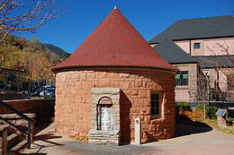
Iron Springs, a neighborhood in Manitou Springs, Colorado, was an area named for one of Manitou Mineral Springs. The Manitou area had been frequented by Native Americans who considered it a sacred and healing place before European Americans settled in Manitou.

Englemann Canyon is a valley along Ruxton Creek, in Manitou Springs, El Paso County, Colorado. It is one of three canyons in Manitou Springs, the others are Ute Pass and Williams Canyon.

<span class="mw-page-title-main">Colorado Springs and Interurban Railway</span> Electric trolley system in Colorado, US

The Colorado Springs and Interurban Railway was an electric trolley system in the Colorado Springs, Colorado area that operated from 1902 to 1932. The company was formed when Winfield Scott Stratton purchased Colorado Springs Rapid Transit Railway in 1901 and consolidated it in 1902 with the Colorado Springs & Suburban Railway Company. It operated in Colorado Springs, its suburbs, and Manitou Springs. One of the street cars from Stratton's first order is listed on the Colorado State Register of Historic Properties.

<span class="mw-page-title-main">Ruxton Creek</span> Stream in Manitou Springs, Colorado, US

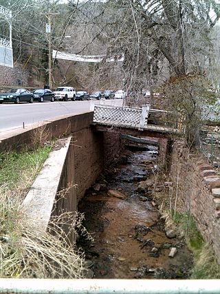
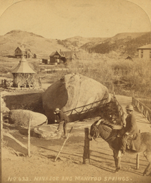
Ruxton Creek is a stream in Manitou Springs in El Paso County, Colorado. Named for British explorer and writer of the southwest, George Fredrick Augustus Ruxton, it is one of three main drainage basins in Manitou Springs. Ruxton Creek flows out of Englemann Canyon and into the town of Manitou Springs. Iron Springs geyser emanates from the creek and is one of the Manitou Mineral Springs.

References

  1. "National Register Information System". National Register of Historic Places . National Park Service. January 23, 2007.
  2. National Register of Historic Places in El Paso County, Colorado. American Dreams. Retrieved May 3, 2013.
  3. 1 2 Eric Peterson (January 29, 2009). Frommer's Denver, Boulder & Colorado Springs. John Wiley & Sons. p. 197. ISBN   978-0-470-46523-3 . Retrieved May 4, 2013.
  4. The History of Manitou Springs, The Manitou Springs Chamber of Commerce, Visitors Bureau & Office of Economic Development, retrieved April 15, 2012
  5. 1 2 3 4 5 Manitou Springs Historic District Nomination Form Archived 2013-11-12 at the Wayback Machine . History Colorado. Retrieved May 3, 2013.
  6. 1 2 3 4 5 6 7 8 9 10 Mineral Springs Foundation (2013). Mineral Springs. manitoumineralsprings.org.
  7. 1 2 Historic Manitou Springs, Colorado - 2013 Visitors Guide. The Manitou Springs Chamber of Commerce, Visitors Bureau & Office of Economic Development. 2013. p. 6.
  8. 1 2 3 4 5 Best of Colorado. Big Earth Publishing. September 1, 2002. p. 82. ISBN   978-1-56579-429-0 . Retrieved May 4, 2013.
  9. 1 2 About. Manitou Springs. Retrieved May 4, 2013.
  10. Deborah Harrison (November 1, 2003). Manitou Springs. Arcadia Publishing. p. 7. ISBN   978-0-7385-2856-4 . Retrieved May 4, 2013.
  11. Celinda Reynolds Kaelin (April 1, 1999). Pikes Peak Backcountry: The Historic Saga of the Peak's West Slope. Caxton Press. p. 9. ISBN   978-0-87004-391-8 . Retrieved May 12, 2013.
  12. Deborah Harrison (November 1, 2003). Manitou Springs. Arcadia Publishing. pp. 7–8. ISBN   978-0-7385-2856-4 . Retrieved May 4, 2013.
  13. Deborah Harrison (2012). Manitou Springs: Then & Now. Arcadia Publishing. p. 11. ISBN   978-0-7385-9596-2.
  14. Frederick M. Hendren (1984). Pikes Peak Legacy. Colorado Springs, Colorado: Great Western Press. pp. 11–12.
  15. Frederick M. Hendren (1984). Pikes Peak Legacy. Colorado Springs, Colorado: Great Western Press. pp. 20–21.
  16. Frederick M. Hendren (1984). Pikes Peak Legacy. Colorado Springs, Colorado: Great Western Press. p. 16.
  17. 1 2 3 4 5 6 7 Mineral Springs Foundation (2013). Manitou Springs List of Mineral Content. manitoumineralsprings.org.
  18. 1 2 3 4 5 6 7 8 Historic Manitou Springs, Colorado - 2013 Visitors Guide. The Manitou Springs Chamber of Commerce, Visitors Bureau & Office of Economic Development. 2013. pp. 10–11.
  19. Deborah Harrison (2012). Manitou Springs: Then & Now. Arcadia Publishing. p. 12. ISBN   978-0-7385-9596-2.
  20. Deborah Harrison (2012). Manitou Springs: Then & Now. Arcadia Publishing. p. 13. ISBN   978-0-7385-9596-2.
  21. Wolverton, Dave. "Mineral Springs Foundation, Manitou Springs, Colorado | Twin Spring". manitoumineralsprings.org. Retrieved October 14, 2018.

Mineral Springs Foundation, historical, photographic and mineral information about each spring.