Ingavi is a province in the La Paz Department in Bolivia. This is where the Battle of Ingavi occurred on November 18, 1841, and where the World Heritage Site of Tiwanaku is situated.

Larecaja is a province in the Bolivian La Paz Department. It was founded by Antonio José de Sucre on October 18, 1826. Its capital is Sorata.

Los Andes is one of the twenty provinces in the central parts of the Bolivian La Paz Department. The province was legally founded on November 24, 1917, during the presidency of José Gutiérrez Guerra. The Spanish name of the province means "The Andes", referring to its position within the Cordillera Real which is part of the Bolivian Andes mountain range. The capital of the province is Pucarani, which has a population of 918 as of the 2001 census. Pucarani is situated in the Altiplano west of the Cordillera Real offering a view of some of its highest mountains such as Ch'iyar Juqhu, Chachakumani, Kunturiri, Wayna Potosí and Chacaltaya.

Omasuyos or Uma Suyu is a province in the La Paz Department in Bolivia. Its capital is Achacachi.

Pedro Domingo Murillo is a province in the Bolivian La Paz Department. It was created on January 8, 1838, with the name Cercado and on October 17, 1912, during the presidency of Eliodoro Villazón, its name was changed in honor of Pedro Domingo Murillo, protagonist of the revolution of June 16, 1809.

Calamarca or Qala Marka is the fourth municipal section of Aroma Province in the La Paz Department of Bolivia. It is located on the Altiplano and its seat is the town of Calamarca.

The Chilla-Kimsa Chata mountain range is situated in Bolivia south east of Wiñaymarka Lake, the southern part of Lake Titicaca, in the La Paz Department, Ingavi Province. The range is named after one of highest mountains, the Kimsa Chata complex rising up to 4,735 metres (15,535 ft) about 15 km south of Tiwanaku.
Qala T'uxu or Qala Tuqu is a mountain in the Cordillera Real in the Andes of Bolivia, about 5,076 metres (16,654 ft) high. It is located in the La Paz Department, Los Andes Province, Batallas Municipality, Chachacomani Canton. It is situated south-west of the mountains Wila Lluxi and Warawarani and north-west of the mountain Phaq'u Kiwuta.
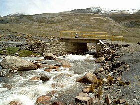
Laram Quta is a lake in the Cordillera Real in the Andes of Bolivia. It is situated in the La Paz Department, Pedro Domingo Murillo Province, La Paz Municipality, La Paz Canton. It lies south-west of the lake Pata Larama. The wetlands of this area are also known as Pampa Larama (Pampalarama, Pamparalama). This is where the Qaluyu River (Kaluyo) originates which downstream is called Achachi Qala and Choqueyapu River.
Qala P'axrani is a 4,262-metre-high (13,983 ft) mountain in the Chilla-Kimsa Chata mountain range in the Andes of Bolivia. It lies in the La Paz Department, Los Andes Province, Laja Municipality. Qala P'axrani is situated south-west of Pukara (Pucara), north-west of the mountain Kunkani. The river Ch'amaka Jawira originates near the mountain. It flows to the north as a left tributary of Wakira River.
Ch'iyar Qullu is a 4,688-metre-high (15,381 ft) mountain in the Bolivian Andes. It lies in the La Paz Department, Murillo Province, Palca Municipality. Ch'iyar Qullu is situated north-east of the mountain Achachi Qala.
Achachi Qala is a 4,505-metre-high (14,780 ft) mountain in the Bolivian Andes. It is located in the La Paz Department, Murillo Province, Palca Municipality. Achachi Qala lies southwest of Ch'iyar Qullu.
Achachi Qala is a mountain in the Chilla-Kimsa Chata mountain range in the Andes of Bolivia which reaches a height of approximately 4,600 m (15,100 ft). It is located in the La Paz Department, Ingavi Province, on the border of the municipalities of Guaqui and Jesús de Machaca. Achachi Qala lies south of Wiñaymarka Lake, the southern branch of Lake Titicaca, northwest of Wanq'uni and southwest of Quta Willk'i.
The Llallawa Jawira which upstream successively is named Patu Uma, Ch'alla Jawira, Jach'a Qura, Lupipi and Chuqi Phuju is a river in the La Paz Department in Bolivia. It is a left tributary of the Desaguadero River.
K'ark'ani is a mountain in the Bolivian Andes which reaches a height of approximately 4,700 m (15,400 ft). It is located in the La Paz Department, Loayza Province, on the border of the municipalities of Luribay and Sapahaqui. K'ark'ani lies northwest of Q'ara Qullu and southwest of Wila Qullu. The Achachi Qala River flows along its western slope. There is a little lake east of K'ark'ani. Its name is Wila Quta.
Achachi Qala is a mountain north of the Cordillera Real in the Andes of Bolivia which reaches a height of approximately 4,760 m (15,620 ft). It is located in the La Paz Department, Larecaja Province, Quiabaya Municipality. Achachi Qala lies southwest of Saywani, northeast of Quriwani and east of Mitalani.
Saywani is a mountain north of the Cordillera Real in the Andes of Bolivia which reaches a height of approximately 4,760 m (15,620 ft). It is located in the La Paz Department, Larecaja Province, Quiabaya Municipality. Saywani lies northeast of Achachi Qala. The little lake south of Saywani is named Ch'uxña Quta.
Achachi Qala is a 4,094-metre-high (13,432 ft) mountain in the Bolivian Andes. It is located in the La Paz Department, Loayza Province, Luribay Municipality.
Achachi Qala is a mountain in the Bolivian Andes which reaches a height of approximately 2,500 m (8,200 ft). It is located in the La Paz Department, Loayza Province, Cairoma Municipality.
Muxsa Willk'i is a 4,490-metre-high (14,730 ft) mountain in the Andes of Bolivia. It is located in the La Paz Department, Pacajes Province, Coro Coro Municipality. Muxsa Will'i lies southwest of Waylla Pukara and west of Achachi Qala.