
The Brienzer Rothorn is a mountain of the Emmental Alps, in Switzerland. With an elevation of 2,350 metres (7,710 ft) above sea level, the Brienzer Rothorn is the highest summit of the range. To its west lies the Tannhorn, whilst to its east are Arnihaaggen, Höch Gumme and the Brünig Pass. On its south side it overlooks Lake Brienz, whilst to the north it looks out over the Waldemme valley.
The Lägern is a wooded mountain of the Jura Mountains, stretching from Baden to Dielsdorf, about 15 km north-west of Zurich. The culminating point is located 1 km west of Hochwacht within the canton of Zurich, the border with the canton of Aargau running on a slightly lower summit named Burghorn.

The Strahlhorn is a mountain of the Swiss Pennine Alps, located south of Saas-Fee and east of Zermatt in the canton of Valais. It lies on the range that separates the Mattertal from the Saastal and is located approximately halfway between the Rimpfischhorn and the Schwarzberghorn.

The Chasseral is a mountain of the Jura Mountains, overlooking Lake Biel in the Swiss canton of Bern. With an elevation of 1,606 metres above sea level, the Chasseral is the highest summit in the canton of Bern outside the Alps. It is also both the northernmost and easternmost mountain reaching over 1,500 metres in the Jura Mountains. West of the summit is located the Chasseral Ouest, where runs the border with the canton of Neuchâtel. The Chasseral Pass is located further on the west.

The Irchel is an elevation in the Canton of Zürich, located at the Rhine between the Töss and Thur rivers, on the territory of Buch am Irchel, Berg am Irchel and Freienstein-Teufen, separating the Andelfingen and Bülach districts. It is an outlying ridge of the Jura, rising to 694 m, lying east of the Lägern. Historically, it was part of the Germanic Limes. The name is from a Helvetic word for "stag".

Lai da Sontga Maria is a lake, located north of the Lukmanier Pass in Switzerland. It lies almost entirely in the municipality of Medel, a tiny fraction of the south-west part of the lake belonging to the municipalities of Quinto and Blenio. The reservoir has a surface area is 1.77 km2 (0.68 sq mi). The arch dam Santa Maria, which is to the north of the lake, was completed in 1968. The main road of the Lukmanier Pass runs along the eastern shore of the lake.

The Eggishorn is a mountain in the southeastern part of the Bernese Alps, located north of Fiesch in the Swiss canton of Valais. A cable car station is located on a secondary summit named Fiescherhorli, 500 metres south of the main peak.

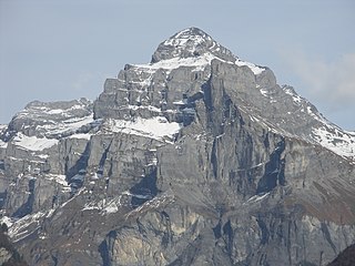
The Portjengrat is a mountain of the Pennine Alps, located on the border between Switzerland and Italy. It lies south of the Weissmies and the Zwischbergen Pass, where the international border diverges away from the main Alpine watershed. The summit of the Portjengrat has an elevation of 3,654 metres above sea level and is the tripoint between the valleys of Saas, Divedro and Antrona. It is the culminating point of the Antrona valley.

The Moléson is a mountain of the Swiss Prealps, overlooking the region of Gruyères in the canton of Fribourg. It lies at the northern end of the chain between Lake Geneva and the valley of the Sarine.

Piz Quattervals is a mountain of the Livigno Alps, located in Graubünden, Switzerland. With a height of 3,165 metres above sea level, Piz Quattervals is the highest mountain of the chain north of Pass Chaschauna. Its mass lies between four valleys: Val Tantermozza, Valletta, Val Sassa and Val Müschauns, although its summit lies between the first three mentioned. Piz Quattervals is the highest accessible peak within the Swiss National Park.

The Pizzas d'Anarosa is a mountain of the Swiss Lepontine Alps, located north of Splügen in the canton of Graubünden. It lies between the Safiental and the Hinterrhein valley. The mountain has several summits, the main summit having a height of 3,002 metres.

Le Châtelet is a mountain of the Swiss Mont Blanc massif, overlooking Orsières in the canton of Valais. It lies between the valleys of Orny and Saleina.

The Etzel is a mountain on the south side of Lake Zürich in Switzerland. Although its elevation, of 1,098 metres (3,602 ft), is relatively modest, it is notable for its aspect when viewed from the lake and its surroundings. It is also well known for its views over the lake, and there is a mountain inn at the summit.

Monte Bisbino is a mountain of the Lugano Prealps, located west of Lake Como. It lies in the Italian region of Lombardy, just 200 metres south of the Swiss border with the canton of Ticino. It has an elevation of 1,325 metres above sea level, the Swiss border reaching a height of 1,244 metres.
The Schafberg is a mountain peak above Boltigen located on the border between the cantons of Fribourg and Berne, north of Jaun. With a height 2,239 metres above sea level, it is the highest summit on the range lying north of the Jaun Pass. It is also the most isolated mountain in the canton of Fribourg.
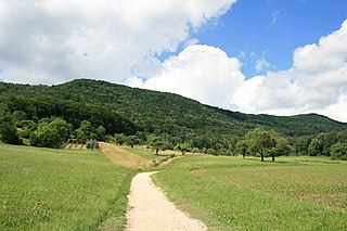
Montagne du Château is the highest hill of the Jorat. It lies west of Montpreveyres in the canton of Vaud, above the city of Lausanne. The hill is entirely wooded, except for its summit, where is a clearing.

Mont d'Or is a mountain of the Jura, located in the French department of Doubs and extending into the Swiss canton of Vaud. Its main summit is 1,463 metre-high and lies within France, 500 metres north of the border with Switzerland. The mountain is located between Jougne, France and Vallorbe, Switzerland.
Pic de Tenneverge is a mountain of the Chablais Alps, located between the French department of Haute-Savoie and the Swiss canton of Valais. Its summit is 2,985 metre-high and lies within France, 300 metres west of the border with Switzerland. The mountain is located between Sixt-Fer-à-Cheval (France) and Lac d'Emosson (Switzerland).

