Serang Regency is a regency of Banten province, Indonesia. It is located in the northwest corner of the island of Java. The administrative center of the regency is at Ciruas, while the capital of the province is the independent municipality of Serang which was split off the regency on 17 July 2007.

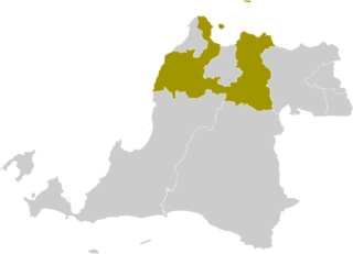
The Jakarta metropolitan area or Greater Jakarta, known locally as Jabodetabekpunjur is the most populous megapolitan area in Indonesia. It includes the national capital as well as five satellite cities and three complete regencies. The original term "Jabotabek" dated from the late 1970s and was revised to "Jabodetabek" in 1999 when "De" was inserted into the name following its formation. The term "Jabodetabekjur" or "Jabodetabekpunjur" was legalised on the Presidential Regulation Number 54 of 2008, and then the name "Jabodetabekpunjur" is officially used.
Cinere is a town and an administrative district (kecamatan) of the city of Depok, in West Java Province of Indonesia. It covers an area of 10.53 km2 and had a population of 107,461 at the 2010 Census and 101,700 at the 2020 Census; the official estimate was 101,600. Cinere District borders to its east on the Jagakarsa District and to its north on the Cilandak District, both being part of South Jakarta City; to the west it borders on the Ciputat Timur District and the Pamulang District of South Tangerang City within Banten Province; and to the south it borders on the Limo District of Depok City. Cinere has a large multi-racial population as a result of long-term transmigration from elsewhere in West Java and from Banten, which began in the late 1960s.

Tangerang Regency is a regency of Banten Province, Indonesia. It is located in the northwest of the island of Java. The current regent is Ahmed Zaki Iskandar. Though commonly misunderstood as being a part of Jakarta, Tangerang is actually outside Jakarta City but is part of Greater Jakarta. Since 1993, the regency has lost territory as first Tangerang city was split off on 27 February 1993 and subsequently South Tangerang city was split off on 29 October 2008. The residual Regency now has an area of 1,034.54 km2 and a population of 2,834,376 at the 2010 census, growing to 3,245,619 at the 2020 census; the latest official estimate is 3,309,365, reflecting a recent slowing down in the rate of population growth since 2020. The town of Tigaraksa is the regency seat.
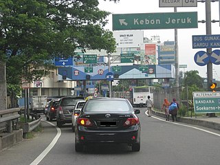
Kebon Jeruk is a district (kecamatan) of West Jakarta Administrative City, Indonesia. Kebon Jeruk is roughly bounded by Kali Pesanggrahan creek to the west, Kebayoran Lama Road to the south, Daan Mogot Road to the north, and Rawa Belong - Batu Sari Road to the east. The area is approximately 17.54 square km, and the official estimate of population as at mid 2023 was 370,282.

Cianjur Regency is a regency (kabupaten) of West Java, Indonesia. The area of the regency is 3,503.75 km2 and its population at the 2010 Census was 2,171,281; the 2020 Census produced a total of 2,477,560 and the official estimate published by the regency government as at mid 2023 was 2,535,002. The town (district) of Cianjur is its seat.
Lebak Regency is a regency of Banten province, Indonesia. It is located on the island of Java. The regency has an area of 3,481.35 km2 and had a population of 1,204,095 at the 2010 census and 1,386,793 at the 2020 census; the official estimate as at mid 2023 was 1,480,593. The town of Rangkasbitung in the north of the regency is the administrative centre. The regency is bordered by the Pandeglang Regency to the west, the Serang Regency to the north, and the Tangerang Regency to the north-east, by the Bogor and Sukabumi regencies to the east, and by the Indian Ocean to the south.

Pandeglang Regency is a regency of Banten province, Indonesia. It is mainly located on the west and south coasts of the island of Java and is the most westerly regency on Java Island, but it also includes several offshore islands such as Panaitan, Peucang, Deli and Tinjil. It is bounded by Serang Regency to the north, Lebak Regency to the east, the Java Sea to the south, and the Sunda Strait to the west. The regency has a land area of 3,053.13 km2, and a population at the 2010 Census of 1,149,610, rising to 1,272,687 at the 2020 Census; the official estimate as of mid-2023 was 1,391,056. The regency seat is the town of Pandeglang in the northeast of the regency, but the most densely-populated district outside of the northeast agglomeration is the town of Labuan on the west coast.
Sukoharjo Regency is a regency in the Central Java province in Indonesia. It covers an area of 493.23 km2 and had a population of 824,238 at the 2010 Census and 907,587 at the 2020 Census; the official estimate as of mid-2023 was 932,680. Its administrative centre is in the town of Sukoharjo, about 10 km south of Surakarta. This regency is bordered by the city of Surakarta in the north, Karanganyar Regency in the east, Wonogiri Regency and the Special Region of Yogyakarta in the south as well as Klaten Regency in the west. The regency is part of the metropolitan zone of Surakarta, which is known as Subosukawonosraten.

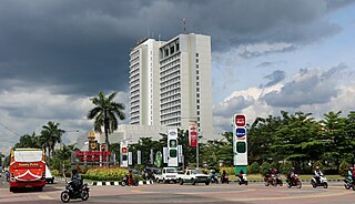
Serang is a city and the capital of Banten province and was formerly also the administrative center of Serang Regency in Indonesia. The city is located towards the north of Banten province, on the island of Java; the north part of the city contains the coast zone facing onto Banten Bay, and includes the historical site of Old Banten, after which the province is named. Before Banten province was formed in 2000, Serang city was part of West Java province.

Karangtengah is a town and an administrative district (kecamatan) of Tangerang City, in Banten Province of Indonesia, on the island of Java. The district covers an area of 10.47 km2, and had a population of 118,473 at the 2010 Census and 117,721 at the 2020 Census; the official estimate as at mid 2023 was 117,440.
Larangan is a town and an administrative district (kecamatan) of Tangerang City, in Banten Province of Indonesia, on the island of Java. The district covers an area of 9.40 km2, and had a population of 163,901 at the 2010 Census and 165,599 at the 2020 Census; the official estimate as at mid 2023 was 151,860.

Balaraja is a town and an administrative district (kecamatan) within Tangerang Regency in the province of Banten, on Java, Indonesia.
Cikupa is a village and an administrative district (kecamatan) within Tangerang Regency in the province of Banten, on Java, Indonesia. The district covers an area of 46.00 km2, and had a population of 224,678 at the 2010 Census and 208,302 at the 2020 Census; the official estimate as at mid 2023 was 209,140. The administrative centre is at Budimulya.

Pamulang is a town and an administrative district (kecamatan) within the city of South Tangerang, in Banten Province on Java, Indonesia. The district covers an area of 28.74 km2 and had a population of 286,270 at the 2010 Census and 305,563 at the 2020 Census; the official estimate as at mid 2023 was 324,059.

Pondok Aren is a town and an administrative district (kelurahan) in the city of South Tangerang, in Banten Province on Java, Indonesia. It is located on the south-western outskirts of Jakarta. The district covers 29.80 km2 and had a population of 303,093 at the 2010 Census and 294,996 at the 2020 Census; the official estimate as at mid 2023 was 295,812.

South Tangerang is a city in the province of Banten, Indonesia. Located 30 km (19 mi) on the southwestern border of Jakarta, the city forms part of the Greater Jakarta metropolitan area. It was administratively separated from Tangerang Regency on 26 November 2008. According to the 2020 Census, the city population was 1,354,350 inhabitants, while the official estimate as at mid 2023 was 1,404,785 - comprising 700,754 males and 704,031 females. The total area is 164.85 km2 (63.65 sq mi). It is the second-largest city in Banten in terms of population, and has grown rapidly, not only as Jakarta's satellite city, but also the development of business districts and commerce due to presence of large-scale planned town by private developers.
Rangkasbitung is a town and an administrative district (kecamatan), in Banten Province of Java, Indonesia. The district covers an area of 73.76 km2, and had a population of 116,659 at the 2010 Census and 134,945 at the 2020 Census, while the official estimate as of mid-2023 was 144,733, comprising 73,678 males and 71,055 females.

Tigaraksa is a town and an administrative district (kecamatan) located in the Tangerang Regency of Banten Province on Java (island), Indonesia. The district covers a land area of 55.30 km2 and had 119,245 inhabitants in 2010 and 155,557 inhabitants in 2020; the official estimate as at mid 2023 was 163,531. The administrative headquarters of the Regency and of the district are located at the town of Tigaraksa.
East Ciputat is an administrative district (kecamatan) in the city of South Tangerang, Banten Province, on Java, Indonesia. It is inside the Greater Jakarta metropolitan area, and is situated to the east of Ciputat. It covers an area of 17.81 km2 and its population was 178,818 at the 2010 Census and 172,139 at the 2020 Census; the official estimate as at mid 2023 was 169,555.

